Home > Historic Landscape Characterisation > Milford Haven Area > |


WEST WILLIAMSTON AND CAREW NEWTON 
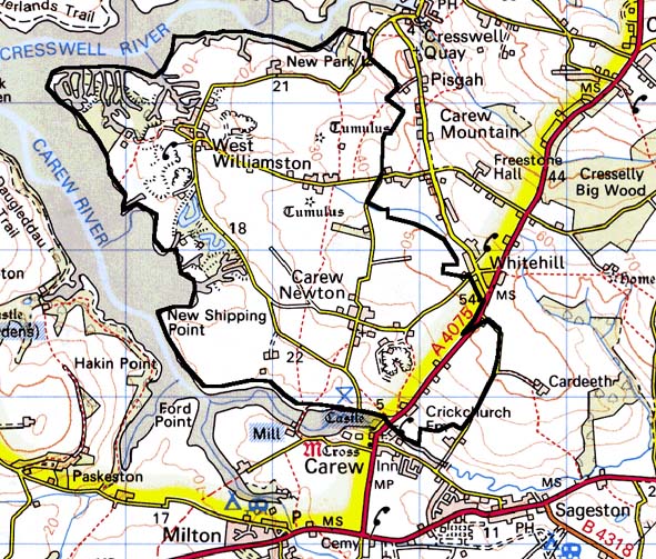
GRID REFERENCE: SN O40050
AREA IN HECTARES: 486
Historic Background
A character area lying between the Carew and Cresswell rivers, two inlets
of the upper reach of the Eastern Cleddau. It lies entirely within the
parish of Carew, which formed the core of the medieval Barony of Carew.
West Williamston, as the Manor of ‘Sagiston and Williamston Harvill’,
was held of Sir John de Carew in 1362 when it comprised one knight’s
fee; it is clear that two manors had coalesced. The holding had ceased
to be manorial by 1600, when George Owen noted its associated park. Both
Carew Newton and West Williamston once had medieval open field systems.
Late 18th century estate maps show the two nucleated hamlets of West Williamston
and Carew Newton still surrounded by these unenclosed open fields, although
its is noticeable that a few strips are enclosed, and a few large fields
lie on the periphery of the open fields, particularly along the Carew
River. Clearly in the late 18th century and early 19th century the medieval
open fields underwent piecemeal enclosure so that by 1839 the tithe survey
of that year shows few unenclosed strips. The enclosure of the open fields
was not accompanied by a dispersal of settlement away from the villages
as occurred at other locations in southern Pembrokeshire. Since the tithe
survey the agricultural landscape and settlement pattern has remained
remarkably static. This character area occupies the limestone belt, and
another defining feature of the landscape is associated with the lime
trade. The quarries on the Carew and Cresswell rivers were developed in
the late 18th century and early 19th century. In order to facilitate loading,
both pills were canalised and a number of channels were cut through the
marsh flats so that barges could come up on the tide to docks. Limekilns
were located close to the docks for the on-site processing of lime. More
quarries lie further inland.
Base map reproduced from the OS map with the permission
of Ordnance Survey on behalf of The Controller of Her Majesty's Stationery
Office, © Crown Copyright 2001.
All rights reserved. Unauthorised reproduction infringes Crown Copyright
and may lead to prosecution or civil proceedings. Licence Number: GD272221
Description and essential historic landscape components
West Williamston and Carew Newton historic landscape character area lies
on a tongue of land between the Cresswell River and the Carew River on
the upper tidal reaches of the Eastern Cleddau. The land here is gently
undulating, achieving a maximum height of about 40m, and merges with extensive
marsh and mud along the rivers. It is an agricultural area and contains
two main settlements, the hamlets of West Williamston and Carew Newton,
but only a few dispersed farms and cottages. Agricultural land-use is
almost entirely improved pasture with just a little arable. A strip field
system, the enclosed open fields that formerly served the two hamlets,
lies across most of this area. These are among some of the best preserved
surviving strip fields around the Milford Haven waterway. Most of the
boundaries comprise banks topped with hedges. Large, distinctive trees
are supported in some lane-side hedges, but most are either well maintained
or becoming overgrown. A few derelict examples are noted. Other less common
boundary types are mortared walls and dry-stone walls, the latter often
in a collapsed state. Limestone for these walls was available from quarries
in this area. The use of limestone as a building material lends a distinctive
architectural signature to this area that is emphasised by the coherent
style of the buildings. Most houses date to the early to mid 19th century,
and are in the Georgian tradition, though some are have vernacular ancestry,
and at least one is in the Victorian ‘villa’ style. Single
storey vernacular workers cottages are also present as are a few late
20th century houses in West Williamston. A late 18th century semi-derelict
farmhouse is located in Carew Newton. The two hamlets retain their agricultural
function. Most of the farms have extensive ranges of stone-built outbuildings,
and while most of these are still in use, some have been converted to
houses, others are not in use or are derelict. A fine late 18th century
two storey range lies in the village of Carew Newton. Modern agricultural
structures are also present. Apart from small stands of deciduous trees
along the sides of the rivers and in a few sheltered hollows, the area
is not strongly characterised by woodland. Remains of the limestone quarrying
industry are extensive along the banks of the rivers, which are bisected
by barge canals. A large 20th century quarry lies in this area. Archaeological
sites although numerous are almost all associated with the limestone quarrying
industry, exceptions are two bronze age round barrows and a small iron
age hillfort. There are no listed buildings.
This area is clearly well defined to the north, west and south by the upper reaches of the Milford Haven waterway. To the northeast the neighbouring area has a strong industrial component, but there is no hard and fast boundary between it and this area. To the east the area has yet to be defined, but it is clear that here the overall characteristics are similar to West Williamston and Carew Newton, although without the strip field element.
Sources: Carew Parish tithe map 1839; Hall et al. 2000; PRO D/BUSH/6/26
& 27; PRO/D/EE/7/338; PRO D/ALLEN/5/105 7 107; Owen 1897