Home > Historic Landscape Characterisation > Milford Haven Area > |

CAREW AIRFIELD 
GRID REFERENCE: SN 054028
AREA IN HECTARES: 123
Historic Background
An inland character area south of the Carew River, an inlet of the upper
reaches of the Eastern Cleddau. It lies entirely within the parish of
Carew, which formed the core of the medieval Barony of Carew. The area,
now lying beneath a disused airfield, was formerly divided between the
demesne of the Manor of Carew to the west, and Sageston to the east. The
latter, as the Manor of ‘Sagiston and Williamston Harvill’,
was held directly by Sir John de Carew in 1362 when it comprised one knight’s
fee. Prior to the construction of the airfield this was an agricultural
area, the former demesne being laid out in a system of large fields. The
creation of some of these enclosures can be attributed to the 16th century
lord Sir John Perrot, as they are recorded in a survey of 1592 following
his attainder to the barony. Some subdivision had occurred by the time
of the tithe survey of 1839. In contrast, the area within Sageston manor,
south of Sageston village, comprised enclosed strip fields that are shown
on an estate map of 1762. This formed part of Sageston manor. It appears
that their post-medieval enclosure was piecemeal and probably undertaken
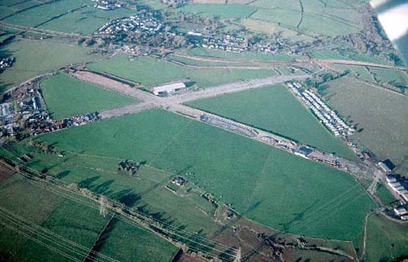
by individual tenants. The airfield at Carew Cheriton was originally established,
as Royal Naval Air Station Pembroke, in 1915 as an aerodrome for airships.
It was one of a number of similar bases around the coastline of Britain
established to counter the growing threat from German U-Boats during World
War 1. At the time the airfield consisted of a single large steel-framed
airship shed, several temporary wooden buildings and some tented accommodation
for the air and ground crews. Aeroplanes were stationed at the airfield
from April 1917 onwards. Canvas hangars were erected in the southeast
corner of the airfield, away from the airship shed and the main station
complex, to service the aeroplanes which were engaged in coastal patrols.
Aeroplanes had replaced the airships by 1919. The station was decommissioned
and closed in 1920 and much of the land auctioned off in lots. None of
the original airship station buildings survive; most were demolished after
the closure of the station, but some remained for a while as agricultural
buildings. The airfield was recommissioned and renamed Carew Cheriton
(to distinguish it from Pembroke Dock) in 1938. Construction work began
in 1938 and by the spring of 1939 the airfield was equipped with canvas
hangars, temporary huts and grass runways. More permanent corrugated-iron
hangars and brick buildings were constructed soon after, and the classic
layout of three interlocking hard runways was also established during
the early 1940s. By 1944 the airfield covered c.128ha. As in World War
1 the airfield was used as a base for maritime patrols and it played an
important role in the Atlantic maritime theatre, until operational flying
ceased in 1942. In 1942 the base became No.10 Radio School, a training
base for aircrew wireless operators, a role it was to perform until the
end of the war. The station closed in 1945.
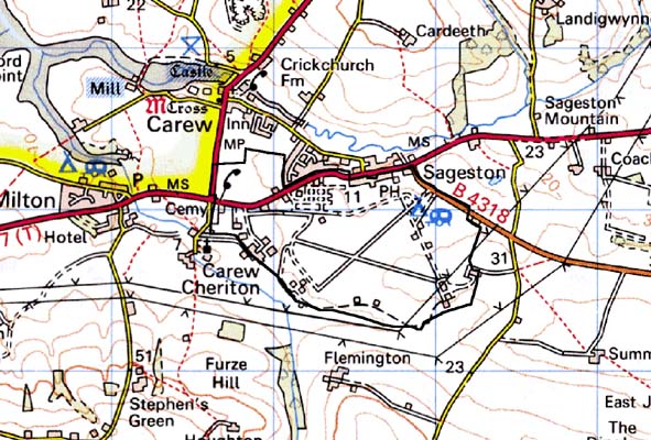
Base map reproduced from the OS map with the permission
of Ordnance Survey on behalf of The Controller of Her Majesty's Stationery
Office, © Crown Copyright 2001.
All rights reserved. Unauthorised reproduction infringes Crown Copyright
and may lead to prosecution or civil proceedings. Licence Number: GD272221
Description and essential historic landscape components
This area consists of the World War 2 airfield. Most of the airfield buildings
have been demolished and a bypass road constructed across the northern
section of the site. Some buildings survive including the control tower,
some ablution blocks and air raid shelters, as do the concrete runways
and parts of the access roads. Some of the buildings now have an industrial
use, and a Sunday market is held on the runways. Land between the runways
is improved pasture.
Sources: Austin 1992; Austin 1993; Brock 1989; Carew Parish tithe map
1839; Ludlow and Murphy 1995; Murphy 1987; Owen 1897; PRO D/BUSH/6/27;
PRO D/BUSH/6/26