Home > Historic Landscape Characterisation > Milford Haven Area > |

HUNDLETON AND MAIDEN WELLS 
GRID REFERENCE: SM 960004
AREA IN HECTARES: 325
Historic Background
A character area on the south side of the Pembroke River. It lies within
the parishes of Hundleton and Monkton. Hundleton parish was created in
the 19th century, from part of the parish of Pembroke St Michael, and
lies within the liberty of the medieval borough of Pembroke. The area
comprised demesne associated with Pembroke Castle and manor, to which
the vills of Maiden Wells, recorded in 1336, and Hundleton, recorded in
1475, were appurtenant. This part of the area became part of the Bush
estate in the post-medieval period. Monkton parish represents the core
ecclesiastical holding of the Benedictine priory of Monkton, Pembroke
that was dissolved in 1535. The name ‘Priory Moor’ preserves
the ownership and land-use elements of a block of land at the highest
point in the area, north of which is Windmill Hill which may represent
the site of one of the priory mills. The Devereux Earls of Essex acquired
the Monkton estate later in the 16th century. It is clear from 18th century
and early 19th century maps that the present day field system of small,
regular fields has evolved, at least in part, from an open field system.
A few enclosed strips were recorded close to Hundleton in 1737 and 1807
– the last remnants of the village’s open fields. By the tithe
survey of 1841 these no longer existed. Elsewhere the pattern of small
fields was firmly established by the late 18th century. The area had been
always primarily agricultural, but the Pembroke River shoreline has been
used as an informal shipping place. During the 18th century it became
an important landing place used for the export of limestone from quarries
at West Grove. Bentlass was another early landing stage associated with
the ferry crossing to Pennar.
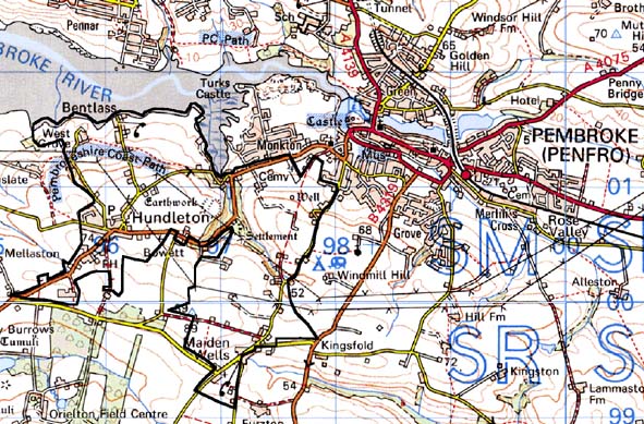
Base map reproduced from the OS map with the permission
of Ordnance Survey on behalf of The Controller of Her Majesty's Stationery
Office, © Crown Copyright 2001.
All rights reserved. Unauthorised reproduction infringes Crown Copyright
and may lead to prosecution or civil proceedings. Licence Number: GD272221
Description and essential historic landscape components
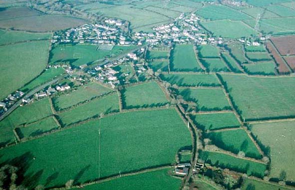
This historic landscape character area lies on the southern bank of the
Pembroke River on undulating land that rises steadily from the shore southwards
to over 80m above sea level. It is essentially an agricultural area but
includes the two villages of Hundleton and Maiden Wells. Fields are regular
and small for southern Pembrokeshire, and are bounded by banks topped
with hedges. Hedges vary in character, with some very overgrown and supporting
small trees, whilst others are well maintained. Sunken lands flanked by
high hedges are characteristic of the area. Overgrown hedges together
with woodland on the steep valley sides of the upper Quoits Water Pill
lend a wooded aspect to sections of the landscape. Agricultural land-use
is almost entirely improved pasture with a little arable. The historic
core of Hundleton village consists of a group of 19th century stone built,
cement rendered, and slate-roofed two storey vernacular houses and single
storey cottages. The parish church was established to serve this community
in the 1840s. However, mid- and late-20th century housing development,
a school and other buildings have considerably expanded the village, and
it now has a much more linear quality stretching along the B 4320 and
minor roads. Maiden Wells is a 19th century linear village. It contains
both detached and terraced 19th century single storey cottages, interspersed
with which is 20th century housing. The Grade II listed Gilead chapel
was constructed in the 19th century to serve this community. The only
other significant grouping of houses is at the old ferry point of Bentlass.
Here there is a 19th century stone-built, Grade II listed warehouse and
several 19th century and 20th century houses. Dispersed farms complete
the settlement pattern. Farms are smaller than average for southern Pembrokeshire.
Farmhouses are generally in the Georgian vernacular tradition, stone-built
with slate roofs. Most farms have one or two ranges of 19th century outbuildings
associated with them, plus collections of modern steel, concrete and asbestos
agricultural structures. Archaeological sites are rich and varied and
include a substantial dam and millpond, two iron age forts, prehistoric
flintworking sites, the site of a holy well, a windmill site and two limekilns
situated close to the foreshore.
This historic landscape area is not well defined where it borders neighbouring agricultural areas. Boundaries should be considered as zones of change rather than hard-edged.
Sources: Laws, 1909; Ludlow 1998; Monkton Parish tithe map 1841; Nash
1986; PRO D/BUSH/6/26, 30, 142 & 144; PRO HDX/198/2; Walker, 1989