Home > Historic Landscape Characterisation > Milford Haven Area > |

ROSEMARKET 
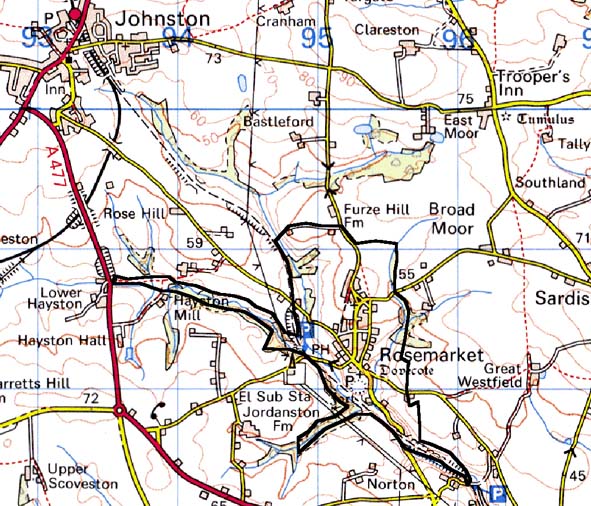
GRID REFERENCE: SM 948083
AREA IN HECTARES: 117
Historic Background
This is a small character area comprising the village and fields of Rosemarket.
The medieval Manor of Rosemarket, coterminous with the parish, was initially
a member of the Lordship of Haverford. It was clearly under joint tenure
when in c.1145 it was granted, along with the parish church, to the Knights
Hospitaller of Slebech by the knights William FitzHait, Robert FitzGodebert
and Richard FitzTancard. Jurisdiction continued to be subordinate to the
Lordship of Haverford. Slebech received £24 annually from the manor
in 1338. A large earthwork enclosure at the southern end of the village
is not fully understood. It may represent an iron age hillfort, but the
village morphology suggests that it was reused as a castle during the
medieval period. It adjoins the parish church, and a planned arrangement
of three parallel streets leads northwards from it. It appears never to
have been fortified in stone and, by the 17th century at least, had been
superseded by a mansion. This lay opposite the church where the present
Cross Farm is located. At the dissolution, the manor fell to the crown
but towards the end of the 16th century one Morys Walter gained control
of many of the tenements and much land and eventually acquired the manor.
The manor remained in the hands of the Walter family until the early 18th
century. It appears to have been subdivided before 1735 when the Walters
leased ‘the capital messuages called Walter’s Hall and the
Hall of Rosemarket’ to William Owen of Landshipping. As noted above,
Walter’s hall lies beneath the present Cross Farm. A dovecote, probably
early 17th century, stands in the adjoining field. From documentary sources
it would seem that by the end of the medieval period Rosemarket was a
small agricultural community centred on the village and surrounded by
open field systems with common land towards the boundaries of the parish.
Howells describes the means by which Morys Walter gained control of many
of the tenements. He enclosed the common fields and turned arable land
to pasture, encroached and enclosed Her Majesty’s commons and put
to ruin houses. By the tithe survey of 1843 the village appears to be
in a thriving condition. The system of small, fairly regular fields close
to the village may well be a result of Walter’s enclosure. However,
enclosed strip fields shown on the tithe map indicate more piecemeal enclosure
of the open fields, perhaps as late as the 18th century. These strip fields
have now been largely amalgamated into rectangular enclosures, and the
only real clue to the former open fields resides in place-names such as
the farm called Westfield. Nineteenth century maps show that settlement
within the village was very sparse indeed. Dwellings were spaced far apart
along the three streets. Much of this space has been infilled during the
20th century. A small area of relict common lay immediately north of the
village. The GWR Haverfordwest-Neyland railway line that opened in 1856
and closed in the 1960s crosses the area, but a station did not serve
the village.
Base map reproduced from the OS map with the permission
of Ordnance Survey on behalf of The Controller of Her Majesty's Stationery
Office, © Crown Copyright 2001.
All rights reserved. Unauthorised reproduction infringes Crown Copyright
and may lead to prosecution or civil proceedings. Licence Number: GD272221
Description and essential historic landscape components
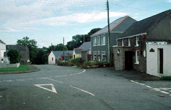
Rosemarket historic landscape character area essentially consists of a
small village together with its neighbouring fields, and deciduous woodland
on steep valley sides. It lies across and to the north of a steep sided
valley. Land above the valley is undulating, but with a south-facing aspect,
and lies between 40m and 60m above sea level. The village has a planned
morphology, with a main north-south aligned street flanked by two parallel
streets, one to the west and one to the east. The medieval church of St
Ishmael, and the possible castle, lie in an axial position at the southern
end of the main street. This street is flanked by the other two streets
that form ‘back lanes’, though possibly not in the formal
sense. Nevertheless, it is possible that crofts and tofts were laid out
between the streets in a system approaching that of urban burgage plots.
Houses which front onto the streets are mostly detached and vary in character
and date, with 19th century one- and two-storey, stone-built, slate-roofed
dwellings broadly in the vernacular style, interspersed with mid to late
20th century houses and bungalows. Small-scale 20th century housing developments
are also present. Several stone-built farm buildings in the village lend
an agricultural aspect to parts of the settlement. There is a public house
and a chapel here. Farms included in this area are generally small. The
grade II* listed masonry dovecote on the outskirts of the village, close
to the former mansion house, is the only listed building. The village
ends abruptly on the south side against a steep sided valley heavily cloaked
in deciduous woodland. A disused railway line that runs down the valley
has recently been converted to a cycle-way. Small fields of improved pasture
lie to the west, north and east of the village. Many of the hedges that
surround the fields are overgrown, and this together with woodland provides
a wooded aspect to the area. Archaeological sites include an iron age
hillfort/castle site, at the southern end of the village, the sites of
several mills, including a fulling mill, a holy well and the dismantled
railway.
The boundaries of Rosemarket historic landscape character area are not easy to define. In essence, this area forms a buffer zone between large farms with large regular fields to the south and a more broken landscape of smaller farms, smaller fields and small stands of woodland to the north.
Sources: Howells 1955-56; Jones 1996; King 1988; Ludlow 1998; PRO D/LLW/30956;
Rees 1897; Rosemarket Parish tithe map 1843; Ordnance Survey 6”
First Ed. Sheet XXXSE, 1869