Home > Historic Landscape Characterisation > Milford Haven Area > |

WEST ANGLE TO FRESHWATER WEST COASTAL STRIP 
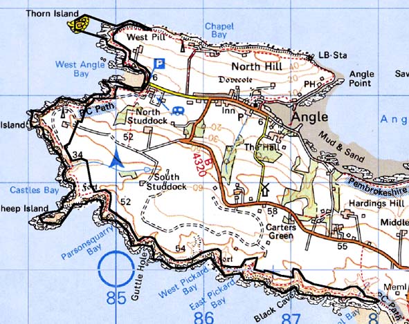
GRID REFERENCE: SM 845022
AREA IN HECTARES: 102
Historic Background
A character area comprising a narrow coastal strip lying within the parish
of Angle. Historically, this coastal strip has always been marginal land,
outside the boundaries of cultivated land. In the past it has been used
for rough grazing. However, it embraces many former occupation sites including
several iron age promontory forts. Castles Bay Camp, opposite Sheep Island,
is an unusual site that was possibly occupied during the early medieval
period, and may feature post-Anglo-Norman Conquest military reuse. Lying
at the mouth of the Milford Haven waterway, this area has long played
an important defensive role. A gun tower was constructed in 1542 at East
Blockhouse. A gun battery built on Thorn Island in 1859 was later converted
to a fort, and finally to a hotel. In 1901-04 massive gun emplacements
were built close the 16th century gun tower. This latter site was in use
during World
War 2 during which a large camp was constructed as well as many smaller
installations. The military still use the site, although the main function
of the coastal strip is as a corridor for the Pembrokeshire Coast Path.
Base map reproduced from the OS map with the permission
of Ordnance Survey on behalf of The Controller of Her Majesty's Stationery
Office, © Crown Copyright 2001.
All rights reserved. Unauthorised reproduction infringes Crown Copyright
and may lead to prosecution or civil proceedings. Licence Number: GD272221
Description and essential historic landscape components
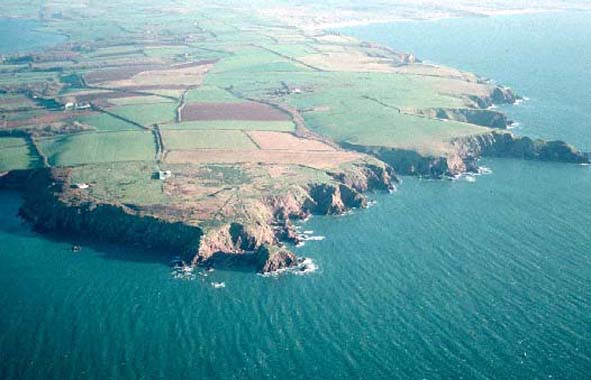
This historic landscape character area consists of approximately a 7 km
strip of high, hard-rock sea cliff topped by a narrow band of moor, scrub
and rough ground. The Pembrokeshire Coast Path runs along the entire length
of this area. Although it comprises a very narrow strip of land, sometimes
just a few metres wide, this area is very different from the highly cultivated
land that bounds it, and for long sections there is no connection between
the cultivated fields and the coastal strip. Essentially the historic
landscape of the coastal strip is characterised by its many and varied
archaeological sites. The most obvious of these are military sites dating
from the 16th century through to the 20th century, including the earliest
surviving military installation on the waterway, East Blockhouse, constructed
in the 16th century, and now reduced to a tottering stone ruin on the
cliff top. Also included is the grade II* listed 19th century fort on
Thorn Island, built in 1859 and now converted to a hotel (itself grade
II* listed), the coast gun battery at East Blockhouse constructed in 1901-04,
and several dispersed installations such as searchlight batteries and
gun emplacements. Buildings at East Blockhouse are still used by the military.
Other archaeological sites include iron age forts, a possible dark age
site at Sheep Island and numerous flintworking floors.
This distinct area is clearly separated from the enclosed farmland that bounds it inland.
Sources: Angle Parish tithe map 1842; Crane 1994; Edwards and Lane 1988; Locock 1994; Murphy and Allen 1997 and 1998