Home > Historic Landscape Characterisation > Newport and Carningli > |

 BRYN-HENLLAN
GRID REFERENCE: SN 014388
AREA IN HECTARES: 461
Historic Background
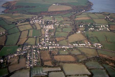
A large area of modern Pembrokeshire, comprising the coastal plain lying between Mynydd Carningli and the sea-cliffs to the north. It lies within the medieval Cantref Cemaes. Cemaes was brought under Anglo-Norman control in c.1100 by the Fitzmartins who retained it, as the Barony of Cemaes, until 1326, when they were succeeded by the Audleys. The Barony was coterminous with the later Hundred of Cemais, which was created in 1536, but many feudal rights and obligations persisted, some until as late as 1922. This character area lies within the parish of Dinas, which represented 1 knight’s fee, held of the Barony of Cemaes, by Welsh tenure. The Dinas name may come from Dinas Head, which itself may be named for its likeness to a dinas (large iron age defended enclosure) rather than from an actual fortification. In the Extent of Cemaes, of 1594, Dinas was held by a ‘divers tenant’ and valued at £4. The parish church of Dinas, St Brynach, lies within the area – Brynach was the ‘patron saint’ of Cemaes. Also within the area is the site of a cist cemetery at Bryn-henllan whose name suggests that it may have been the predecessor of St Brynach’s. Both sites may have early medieval origins. The area around the church, now called ‘Cwm-yr-eglwys’, may represent the ‘Trefawr’, which was listed as a holding in the Extent along with Bryn-henllan and Fron Fawr, the latter now devolved into two farms. The present field pattern, of fairly small irregular fields, has the appearance of post-medieval enclosure. It is possible that a major landscape re-organisation may have taken place - the eastern half of the area, for instance, is labelled ‘Forest’ on Rees’ map of 14th century south Wales. However, fossilised strip-fields are evident in the area immediately west of Bryn-henllan. The tithe map of 1841 shows some enclosed strip fields as well as small fields in a pattern not dissimilar to that of today, although some dwellings have disappeared, new clusters have developed and some of the smaller fields have been amalgamated. Dinas parish church was largely destroyed through coastal erosion in the mid 19th century and is now an incomplete ruin. A new church was built near what is now Bryn-henllan village, which, along with the earlier non-Conformist chapel nearby, became the nucleus for the new settlement. The A487(T), which crosses the area, more-or-less follows the line of a medieval (and earlier?) routeway. The ribbon-development at Dinas Cross, however, all appears to be post-medieval and the majority is 19th century and 20th century in origin. It now forms a settlement in its own right and has eclipsed Dinas and Bryn-henllan. Dinas/Cwm-yr-eglwys is now a popular holiday beach, with a nearby caravan park.
Description and essential historic landscape components
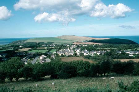
Bryn-henllan historic landscape character area lies on an undulating, sloping north-facing coastal plain between approximately 40m and 90m above sea level, with steeper, higher slopes up to 160m to the south. It is a complex area consisting of farms and fields, old hamlets and modern housing, and tourist facilities. Essentially it is an agricultural landscape that has experienced considerable change in recent years with many of the smaller farms converted to other uses. Agricultural land-use is almost entirely improved pasture, with very little arable or rough ground. Although swept by the winds from the Atlantic, parts of this landscape has a wooded appearance on account of the many trees planted for shelter. There is also some scrubby deciduous woodland and steep, sheltered valley sides. Fields are generally small and irregular in shape, with groups of long curved strip-shaped fields attesting to the former presence of open field systems. Boundaries are stone-faced banks topped with hedges. The condition of these varies, with some well maintained and stock-proof, but with many overgrown and others, in exposed locations, straggling. Dwellings are centred on two core areas, Dinas Cross and Bryn-henllan. These were two separate centres, but recent housing development has merged them into one. Older, almost exclusively 19th century, buildings are united by the use of local blue-grey and warm brown local dolerite stone (not usually cement rendered) and machine cut slate roofs – these building are not dissimilar to those found at Newport, 5km to the east. On the better quality houses consideration has been given to the patterns produced by contrasting/matching stone colour, and the use of courses of Cilgerran slate slabs and/or limestone quoins provides a formality lacking in lesser structures. At Dinas Cross the older houses, and a shop and public house, are arranged in a terrace. Most date to the early-to-mid 19th century and are in the polite ‘Georgian’ tradition, although many show a strong vernacular element. Other older houses include later 19th century two-storey, three-bay detached dwellings, some said to be built by retired sea captains, in the polite ‘Georgian’ style. Mid 20th century detached ‘villas’ lie alongside the main A487(T) that runs through Dinas Cross, and a small, early 19th century chapel is situated on the road to the east. Bryn-henllan originally seems to have contained several small clusters of buildings, including one centred on the stone-built chapel of 1842. Dwellings are in various styles, with several late 19th century two-storey houses in the polite Georgian style, a collection of single storey double-fronted vernacular cottages, as well as small, three-bay houses in the vernacular tradition probably dating to the early 19th century. A pair of listed semi detached houses dated 1872, Llwynhendy and Hafod Llwyd, in the Georgian tradition, are typical of dwellings of this date and are said to have been built by retired sea captains. Other listed buildings include a cottage, a farmhouse and a chapel, which generally reflect the older type of building stock of the area. Small ranges of stone-built farm buildings attached or associated with some of these dwellings indicate the agricultural origins of the houses, but most of these farm buildings have been converted to non-agricultural use or are derelict. Mid 20th century, late 20th century and current housing development, either in small estates or individual dwellings, in a variety of styles and materials has united Dinas Cross and Bryn-henllan into one village. Included in this area are the remains of the medieval parish church at Cwm-yr-Eglwys and 19th century and other buildings at Pwllgwaelod. Here, as in other exposed locations a cement skim has been applied to the slate roofs. Farms in the area are relatively small, with houses in the same tradition as those described above. Older farm buildings are stone-built and of just one or two ranges. Many have been converted to non-agricultural use. This and the few examples of 20th century steel, concrete and asbestos agricultural structures indicate that many farms are not now engaged in agriculture. There are also a school, sports field, caravan park and tourist car parks. Apart from the ruined parish church at Cwm-yr-Eglwys, archaeological sites do not strongly characterise this landscape. Archaeology includes bronze age standing stones, a cist cemetery, a holy well and a limekiln.
Bryn-henllan is not an easy historic landscape character area to define, except at its northern edge where it borders sea cliffs or the distinctive landscape of Dinas Island. Elsewhere there is a merging of this area with its neighbours, and no hard-edged boundaries.
Sources: Charles 1992; Dinas Parish tithe map 1841;
Howells 1977; Ludlow 2002; Pembrokeshire Record Office D/CT/26 (1839);
National Library of Wales Llwyngwair Map 5; Rees 1932
Base map reproduced from the OS map with the permission
of Ordnance Survey on behalf of The Controller of Her Majesty's Stationery
Office, © Crown Copyright 2001.
All rights reserved. Unauthorised reproduction infringes Crown Copyright
and may lead to prosecution or civil proceedings. Licence Number: GD272221