Home > Historic Landscape Characterisation > Newport and Carningli > |

 CARNINGLI
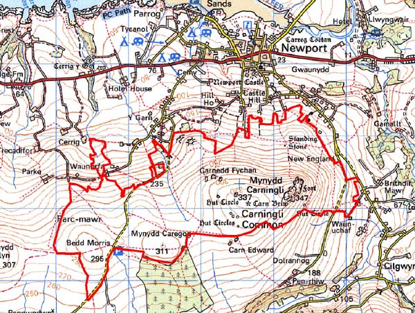
GRID REFERENCE: SN 050373
AREA IN HECTARES: 499
Historic Background
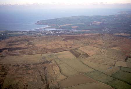
This relatively large area of modern Pembrokeshire comprises the upland moorland of Mynydd Carningli south of Newport town. It lies within the medieval Cantref Cemaes. Cemaes was brought under Anglo-Norman control in c.1100 by the Fitzmartins who retained it, as the Barony of Cemaes, until 1326, when they were succeeded by the Audleys. The Barony was coterminous with the later Hundred of Cemais, which was created in 1536, but many feudal rights and obligations persisted, some until as late as 1922. This character area is a typical Welsh upland landscape in that it contains extensive evidence of prehistoric occupation, mainly ritual and funerary monuments but also occupation sites such as hillforts and hut groups, and their associated field systems. Carningli hillfort is a large enclosure and presumably represented the major population centre of the region, but its drystone banks are not typical of iron age enclosures and a neolithic date and a early medieval date have both been suggested for its construction. The Bedd Morris standing stone was incorporated in the later boundary of the parish (and borough) of Newport, and also formed a route node for the medieval Newport-Haverfordwest highway, or ‘Ffordd Bedd Morris’, which still crosses Mynydd Carningli. In the medieval period Mynydd Carningli lay within the borough of Newport, which was more-or-less coterminous with Newport parish. Mynydd Carningli was held directly by the Lords of Cemaes, but in 1278 Nicholas Fitzmartin issued a charter, specifying the borough boundaries and granting the burgesses right of common grazing over ‘all my land wet and dry, moors and turbaries’on Mynydd Carningli. The charter defined this as a large area lying between the arable land along the Clydach, the arable holding of Dolranog (Gochel Sythi character area), Mynydd Melyn, the highway, the holding of Parc-y-marriage, and Cwm Rhigian. Mynydd Carningli was still recorded as unenclosed land over which the burgesses of the borough had right of common pasture for ‘all manner of cattle’, in the late 16th century Extent of Cemaes. It appears that, during the medieval period, the unenclosed land of Mynydd Carningli extended down the northern slopes as far as the town of Newport, and that the belt of enclosure that now lies between the two is entirely post-medieval in origin. It results partly from squatter enclosure (see Y Garn Parke character area), but right of common pasture had ceased by the early 19th century. The northern part of Mynydd Carningli includes several rectilinear enclosures belonging to short-lived post-medieval farmsteads, probably mainly late in origin, but abandoned by the mid 19th century. Old quarries within the area are reminders that stone extraction was once a small but significant industry in north Pembrokeshire.
Description and essential historic landscape components
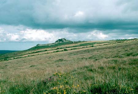
Mynydd Carningli consists of a steep sided hill topped by craggy rock outcrops that rises to over 330m above the town of Newport to the north and the Gwaun valley to the south. Situated at the eastern end of the hill, the massive rocky mass of Carningli hillfort is a dominant landscape feature, visible from much of north Pembrokeshire. Essentially this is an unenclosed historic landscape area consisting of heather and bracken moorland with pockets of rough pasture. There are, however, old stone-faced boundary banks and broken down field walls running across the lower parts of this common, and on the fringes old fields are reverting to moorland blurring the distinction between moor and lower-lying farmland. These and a large stone-faced bank that runs alongside the public road over the common demonstrate past attempts to bring the moorland under cultivation. There are no buildings on the common, but the numerous prehistoric and later archaeological sites – over 50 are recorded - strongly characterise the historic landscape. These include: the massive hillfort of Carningli and many ancillary settlements; Carn Ffoi iron age hillfort; several round huts, some associated with field systems and agricultural clearance cairns; bronze age burial mounds or round barrows; Bedd Morris standing stone; and deserted settlements of medieval or later date. There are also several old quarries, including an extensive one with and incline leading from it on the eastern flank of the mountain.
Although Carningli is a distinctive historic landscape character area, its boundaries are not all well defined. On the eastern side the steep slope of common terminates abruptly against boundary banks and hedges of farmland. Elsewhere the border between the common and farmland is becoming blurred as fields are allowed to revert to moor and boundaries are neglected.
Sources: Bignall 1991; Cadw 2001; Hogg 1973; Howells
1977; Lewis 1833; Miles 1995; Newport Parish tithe map 1844; Rees 1932
Base map reproduced from the OS map with the permission
of Ordnance Survey on behalf of The Controller of Her Majesty's Stationery
Office, © Crown Copyright 2001.
All rights reserved. Unauthorised reproduction infringes Crown Copyright
and may lead to prosecution or civil proceedings. Licence Number: GD272221