|

 GARNWNDA
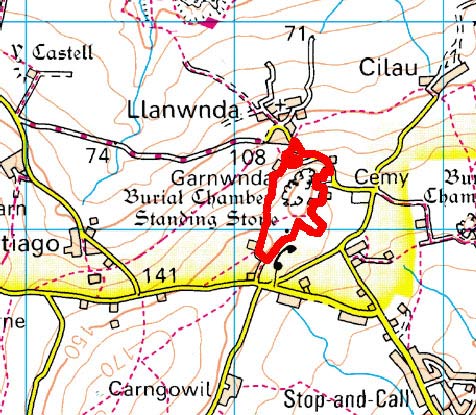
GRID REFERENCE: SM 932391
AREA IN HECTARES: 9
Historic Background
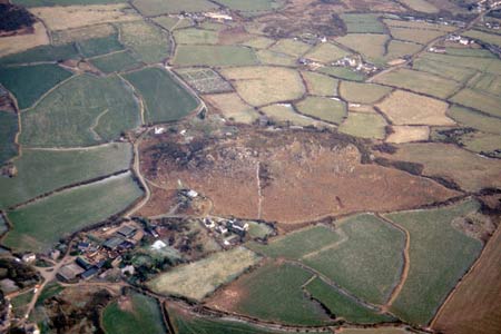
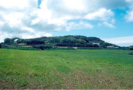
A small area of modern Pembrokeshire comprising a rocky knoll just south of the hamlet of Llanwnda, within Llanwnda parish. During the medieval period the area formed part of the medieval Cantref Pebidiog, which was conterminous with the later Hundred of Dewsland created in 1536. It was held directly by the Bishops of St David’s, having represented the core of the bishopric from 1082 when it was granted (or confirmed) by Rhys ap Tewdwr, king of pre-Anglo-NormanConquest Dyfed, to Bishop Sulien. From 1115 onwards, when Bernard was appointed Bishop of St David’s, Anglo-Norman systems of feudal government and ecclesiastical administration were introduced into Pebidiog and the Llanwnda character area occupied Villa Grandi, which was referred to as a manor in 1326 but possibly not in the formal, Anglo-Norman sense. Welsh tenurial systems appear moreover to have persisted, although variously adapted, while many feudal rights and obligations continued into the early 20th century. This character area has probably always been unenclosed and never subject to any intensive land-use. It is shown in its present form on the tithe map of 1845, and may have previously been held as informal waste or common. However, it formed a focus for prehistoric ritual and funerary activity, evidenced by a neolithic chambered tomb and a bronze age standing stone, which are highly visible from similar monuments in the Garn Fawr character area to the west.
Description and essential historic landscape components
This is a very small, but nevertheless distinctive, historic landscape character area of just nine hectares of craggy moorland surrounded by farmland. Garnwnda rises as a rocky outcrop of moorland to over 160m. Although distinctive, it contains few historic landscape components, and is characterised by its open aspect. There are no buildings. Archaeological sites consist of a scheduled neolithic chambered tomb, a bronze age standing stone and a possible standing stone.
This is a distinctive historic landscape character area and contrasts with the surrounding landscape of farms and fields.
Sources: Llanwnda Parish tithe map 1845
Base map reproduced from the OS map with the permission
of Ordnance Survey on behalf of The Controller of Her Majesty's Stationery
Office, © Crown Copyright 2001.
All rights reserved. Unauthorised reproduction infringes Crown Copyright
and may lead to prosecution or civil proceedings. Licence Number: GD272221