Home > Historic Landscape Characterisation > Upland Ceredigion > |

 BERTHGOED
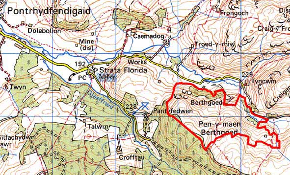
GRID REFERENCE: SN 767649
AREA IN HECTARES: 98.4
Historic Background
In the Medieval Period this area lay within Strata Florida Abbey’s Pennardd Grange. On the Dissolution the granges were granted to the Earl of Essex, who sold them in 1630 to the Crosswood estate. However, the upland, unenclosed character of this area probably ensured that it was claimed as Crown land. Very little is known about this area until the mid 19th century when the tithe map (Caron Tithe Map and Apportionment, 1845) shows this area divided into sheep-walks, presumably by the extant dry-stone walls, with some small enclosures and settlements beginning to encroach from the east. This area of enclosure was extended in the second half of the 19th century. Enclosures and settlements are now abandoned. Lacking other evidence, it is assumed that these were squatter settlements.
Description and essential historic landscape components
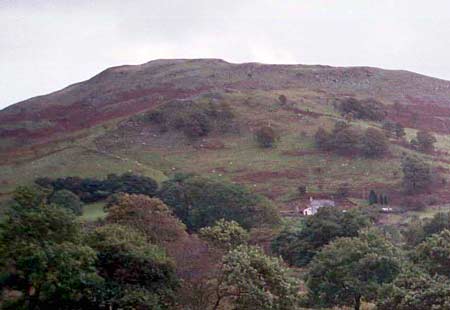
Berthgoed is a very steep and craggy north-facing valley side of the Afon Mwyro ranging in height from 210m to 420m. Essentially this area exhibits many of the characteristics of the unenclosed land to the southeast, but has been separated from it as it contains some old boundaries and woodland. The eastern end of the area contains some abandoned small and medium sized enclosures bounded by collapsing dry-stone walls. To the west on very steep slopes semi-derelict dry-stone walls once divided this area into large sheep-walk enclosures. Most of this area is bracken covered or very rough grazing, which is being colonised by deciduous woodland. This woodland is beginning to form small stands on some of the steeper slopes.
The recorded archaeology of this area comprises deserted farmsteads and cottages of probable late 18th and 19th century date. These testify to the post-Medieval colonisation and later abandonment of this landscape.
To the north the border of this landscape area is well
defined where it meets the valley floor. A forestry plantation lies to
the south and southwest, and enclosed land to the west. To the east this
area merges with unenclosed upland.
Base map reproduced from the OS map with the permission
of Ordnance Survey on behalf of The Controller of Her Majesty's Stationery
Office, © Crown Copyright 2001.
All rights reserved. Unauthorised reproduction infringes Crown Copyright
and may lead to prosecution or civil proceedings. Licence Number: GD272221