Home > Historic Landscape Characterisation > Upland Ceredigion > |

 BONT-GOCH
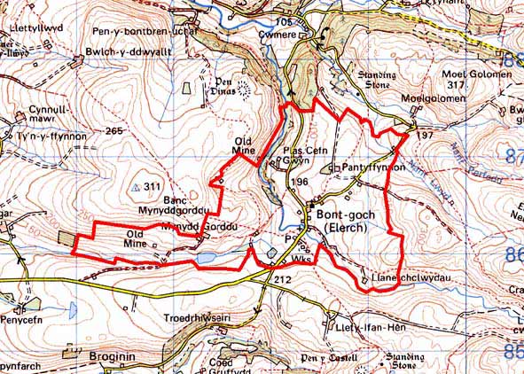
GRID REFERENCE: SN 687864
AREA IN HECTARES: 311.4
Historic Background
The history of this area has not been researched. By the late 18th century some holdings in this area were in the possession of the Crosswood and Court Grange estates. Late 18th century estate maps (NLW Crosswood 345/46; NLW Vol 38, 16) show a very different landscape from that of today. Two centuries ago very little settlement and enclosure existed here, although some cottages on unenclosed moorland are depicted, as well as one farm shown surrounded by a few small fields and woodland on steeper slopes. Metal mines were also depicted. Indeed it is the metal mining industry that provided the stimulus for settlement. Llanerch-clwydau mine is quite ancient. It was worked in the 17th century, but not later. Mynydd Gorddu mine was active in the second half of the 19th century, seemingly coming to an end before the end of the century (Bick 1988, 31-2). Cottages and other settlements gradually developed during the 19th century, and land was enclosed. A church was established in 1868 (Jones 1998, 487), and later a school. It is likely that many of the cottages originated as squatter settlements on unenclosed land. The 20th century has witnessed a slow abandonment of dwellings. A water works was built in the 20th century; the original structure now replaced by a modern installation. The garden at Plas Cefn-gwyn is recorded on the Welsh Historic Gardens Database.
Description and essential historic landscape components
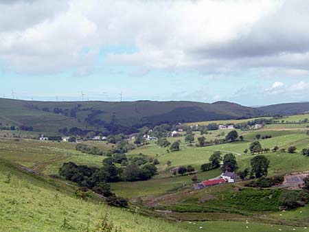
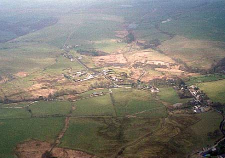
This complex area is centred on the open, upper valley of the Afon Leri, situated between 150m and 250m. Bont-goch is a loosely clustered village surrounded by a pattern of widely dispersed farms and houses.
A group of 19th century buildings lies at the core of Bont-goch. These include: St Peter’s high Victorian church, the former Victorian church school, Plas Cefn Gwyn a late Georgian country house, the old Victorian vicarage, a small chapel with attached house and a 19th century corn mill. All the above are listed. Stone – left bare, painted or rendered - is the traditional building material, with slate for roofs. Other older buildings in the village include several vernacular two-storey cottages/small houses, plus some late 19th century houses with stronger polite Georgian characteristics. Many of these 19th century houses have been modernised, and modern houses and bungalows infill the gaps between the older buildings. Indeed modern housing is becoming the dominant building type of the village. Also present is a stone-built water works close to the centre of the village, now dwarfed by a modern installation of concrete and steel. Dispersed farmhouses/houses are generally mid-to-late 19th century, are relatively small, of two storeys and in the typical Georgian vernacular style –gable end chimneys, central front door, two windows either side of the door and one above. Older farm outbuildings are relatively small and of one or two ranges. Working farms usually have medium sized modern concrete and steel agricultural buildings, although one very extensive range of modern buildings was noted. There is little modern housing outside the village.
The field pattern is of small irregular enclosures divided by earth and stony banks. Hedges no longer exist or only survive in a derelict state on lower slopes, apart from alongside roads where they are in good condition. At the time of the survey one roadside hedge was being laid. Occasional distinctive hedgerow trees survive on some boundaries. Stands of deciduous woodland are present. This old field pattern is beginning to decay; not only are most fields now divided by wire fences, but in some areas pasture has reverted to rough, rushy ground. Some peaty hollows are evident. However, other fields are now of improved grazing. The remains of the metal mining industry are a prominent historic landscape component, especially towards the western end of the area - Mynydd Gorddu mine - where extensive tips survive.
Recorded archaeology mostly consists of metal mine remains and associated features such as leats and reservoirs, or buildings and deserted settlements. Greater time-depth to the landscape is provided by a Medieval holy well with a possible Dark Age dedication to St Padarn, several Bronze Age burnt mounds or hearths - possible settlement sites, and a possible Bronze Age standing stone.
This area is well defined on all sides except to the north where it merges with neighbouring areas. Elsewhere, high, formerly unenclosed land borders this area.
Base map reproduced from the OS map with the permission
of Ordnance Survey on behalf of The Controller of Her Majesty's Stationery
Office, © Crown Copyright 2001.
All rights reserved. Unauthorised reproduction infringes Crown Copyright
and may lead to prosecution or civil proceedings. Licence Number: GD272221