Home > Historic Landscape Characterisation > Upland Ceredigion > |

 CWM RHEIDOL
GRID REFERENCE: SN 711788
AREA IN HECTARES: 145.3
Historic Background
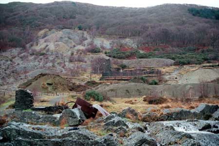
The early history of this area has not been researched. It is assumed that the pattern of dispersed farms and small irregular enclosures on the valley floor is of some antiquity - it was well established by the tithe survey of c. 1840. Lead mining is considered to be of some antiquity in the valley. On the south side of the valley four mines operated up to 1855 when they were consolidated into the Rheidol United Mines (Prichard 1985, 5-7). Ownership changed and new companies were formed, but mining continued throughout the 19th century and into the 20th century, finally ending in 1933. On the north side of the valley Caegynon mine was developed in the 1850s, and Cwm Rheidol worked for blende (Zinc Sulphide) from 1900 to 1912 (Bick 1983, 22, 33; Carr and Schöne 1993, 56-62). The latter was powered by a turbine and was linked via an aerial ropeway to the Vale of Rheidol Railway. In the 1950s and early 1960s, the Rheidol hydroelectric scheme, which was completed in 1964, resulted in the construction of a turbine house, ancillary buildings and a dam creating a small reservoir (Walker 1998, 31). A chapel was built in the valley in 1872, and a Sunday school in 1905.
Description and essential historic landscape components
This area is essentially the valley floor of the Rheidol, which lies at between 50m and 60m, but includes valley sides up to 150m where there are mining activities. Apart from the western end of the valley, steep, wooded valley sides enclose this area. Though quite a small area, it contains complex industrial remains superimposed onto an agricultural landscape. The agricultural landscape consists of a settlement pattern of dispersed farms. Earth banks topped with hedges enclose fields. Hedges are in poor condition: derelict, overgrown or non-existent. Wire fences form stock-proof boundaries. Industrial remains form a prominent and important component of the historic landscape. The most obvious remains of the metal mining industry are the spoil heaps and tips, which spill down the valley sides and onto the valley floor, and the worker housing that is dispersed along the valley floor. Metal mining buildings tend to be concentrated on the valley floor and comprise mostly ruinous stone-built structures, but corrugated iron sheds are present at Caegynon. At Cwm Rheidol mine, apart from the turbine house, most buildings are located on the valley side. Up to a few years ago the impressive remains of an early 19th century dressing plant were located here, but this has now been demolished, although some earlier stone structures including a crusher house remain. The reservoir, dam and modern buildings of the Rheidol hydroelectric scheme at the western end of this landscape area constitute prominent and important, if relatively recent, components of the historic industrial landscape.
Buildings of this area are a mixture of agricultural and industrial, with both types intermixed in a fairly dense linear pattern along the valley floor. Houses of both types – agricultural and (mine) worker - are in the same broad mid-to-late 19th century regional Georgian vernacular tradition. They are stone built – bare stone, cement rendered or painted – and are relatively small, of two storeys. Most have strong vernacular traits, especially the worker houses. Stone-built farm outbuildings are small, often of one or two ranges, with examples attached to and in-line with the house, as is normal with the smallest of farm holdings. River cobbles have been used in some outbuildings. Traces of whitewash are also present on some outbuildings. Modern farm buildings are also small, where present. A scattering of modern houses and bungalows are distributed along the valley, but with a marked concentration at the western end close to the hydroelectric generating buildings. A small 19th century chapel and early 20th century chapel/school add to the character of this area.
Recorded archaeology consists entirely of post-Medieval sites, and the remains of the metal mining industry dominate these. No time-depth to the landscape is provided by the archaeology.
This is a very well defined historic landscape area. To the west lies the more open, less industrialised section of the Rheidol valley. On all other sides steep wooded slopes tower over the valley floor.
Base map reproduced from the OS map with the permission
of Ordnance Survey on behalf of The Controller of Her Majesty's Stationery
Office, © Crown Copyright 2001.
All rights reserved. Unauthorised reproduction infringes Crown Copyright
and may lead to prosecution or civil proceedings. Licence Number: GD272221