Home > Historic Landscape Characterisation > Upland Ceredigion > |

 CWMSYMLOG
GRID REFERENCE: SN 697838
AREA IN HECTARES: 37.6
Historic Background
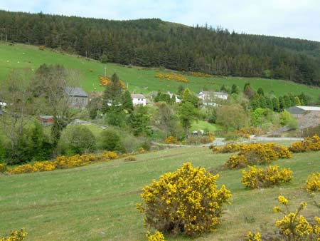
This history of this narrow and deep valley is dominated by the metal mining industry. Cwmsymlog is a very ancient mine. It was certainly worked in the reign of Elizabeth I, and in the mid 18th century was described by Lewis Morris as ‘the richest in Lead and Silver of any of his Majesty’s Dominions’ (Bick 1988, 19). From the 1620s, under Sir Hugh Myddelton, the mine and community developed, and a chapel was built to serve the mineworkers. A Cornish engine was installed in 1840, but by then the reserves were virtually exhausted, and the mine closed soon after. It was, however, reopened in 1850 as East Darren Mine and worked successfully until 1882. Subsequently several attempts were made to reopen workings, but mining finally ceased in 1901. Estate maps of the late 18th and early 19th century (NLW Gogerddan 68; NLW Vol 37, 64) show the mine workings at Cwmsymlog with a scattering of dispersed cottages, each with an enclosed small field or garden. The valley sides are shown as unenclosed moorland. The settlement went into decline in the 20th century, and cottages and houses were abandoned. There has been a recent revival of fortunes, with houses having been renovated and new ones constructed.
Description and essential historic landscape components
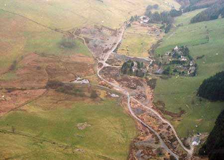
This area comprises the eastern terminal of a narrow and very steep-sided valley. From the valley floor at 190m, valley sides rise steeply to the north, south and east to over 300m. The entrance to the valley is via a narrow pass to the west. Only the valley floor and lower slopes, which contain the remains of the metal mining industry and the settlement of Cwmsymlog, are included in this area. The remains of the metal mining industry comprise the most dominant component of the historic landscape. A chimney which may have been part of the steam power system of the works, or a part of the ventilation system, dominates a scene of tips, shafts, open-casts, cuttings, wheel-pits and old mine buildings. A nearby quarry is reputed to be the source of stone for the mine buildings and cottages. Many of the domestic/non-industrial buildings of the mining settlement survive. These are loosely clustered on the north side of the valley floor and include a listed well-preserved small chapel, a detached two-storey house in the polite Georgian tradition (assumed to be the mine manager’s house), a short terrace of mid to late 19th century vernacular worker houses and a few modern houses. The size of the worker houses suggests they were for supervisors/administrators rather than ordinary workers. The older buildings are of stone, mostly cement rendered, with slate roofs. Some have slate hung elevations. A two storey farmhouse in the mid –to-late 19th century polite Georgian tradition of good quality stone lies to the west of the industrial settlement, with a substantial range of stone outbuildings set around a yard on the opposite side of the road. Abandoned house and cottage sites, often surrounded by dry-stone walls, testify to 20th century depopulation. There is very little good quality agricultural land - most land is open or semi-open rough grazing.
Recorded archaeology is entirely composed of standing buildings or the remains of the metal mining industry.
This is a very distinct and well-defined landscape area. To the north on high ground lies a forestry plantation, and on all other sides there is high unenclosed or semi enclosed rough pasture and improved grazing.
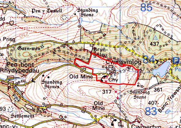
Base map reproduced from the OS map with the permission
of Ordnance Survey on behalf of The Controller of Her Majesty's Stationery
Office, © Crown Copyright 2001.
All rights reserved. Unauthorised reproduction infringes Crown Copyright
and may lead to prosecution or civil proceedings. Licence Number: GD272221