Home > Historic Landscape Characterisation > Upland Ceredigion > |

 CWMYSTWYTH
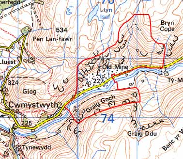
GRID REFERENCE: SN 806748
AREA IN HECTARES: 137.6
Historic Background
This historic landscape area has been defined by the mining industry. Archaeological excavations have demonstrated that opencast copper mining was undertaken here in the Bronze Age (Timberlake 1995), and lead has been mined here since at least Roman times (Bick 1974, 19-23; Hughes 1981). Metal was probably worked under the control of Strata Florida Abbey in the Middle Ages as this area lay within Cwmystwyth Grange. In the 18th century prospecting for lodes by scouring the surface of the ground by a sudden rush of water - hushing - was practised, and the channels and reservoirs of this process can still be seen. Metal mining in the 18th and 19th centuries has bequeathed a bewildering array of remains, an industrial archaeologist’s paradise, including: tips, shafts, tramways, inclines, open-casts, crusher houses and other buildings. In the late 19th century the search for blende resulted in the construction of a large crusher house - the rusting remains of which have only recently been swept away - and other installations. Work finally ceased at Cwmystwyth in 1921.
Description and essential historic landscape components
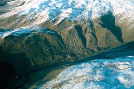
This area, which is entirely defined by industrial archaeology, lies across the valley sides and the valley floor of the Ystwyth. The valley here has a deep U-shaped profile, with the floor at 300m and the sides rising to over 500m. The sides are craggy, even cliff-like on the northern side. The many scree slopes are more likely to be a result of mining than a natural process. Mining remains are everywhere. These are varied and most are of a robust character. Remains of stone built structures in this area – domestic and industrial are scattered across the landscape. Many are in a perilous condition.
Recorded archaeology comprises remains directly associated with the metal mining industry, including finds of Roman date, or remains indirectly associated with the industry such as abandoned worker cottages.
This is a well-defined area comprising the industrial archaeology of the metal mining industry. To the north and south lies high, unenclosed moorland, and to the east and west the enclosed and settled valley floor of the Ystwyth is found.
Base map reproduced from the OS map with the permission
of Ordnance Survey on behalf of The Controller of Her Majesty's Stationery
Office, © Crown Copyright 2001.
All rights reserved. Unauthorised reproduction infringes Crown Copyright
and may lead to prosecution or civil proceedings. Licence Number: GD272221