Home > Historic Landscape Characterisation > Upland Ceredigion > |

 DISGWYLFA
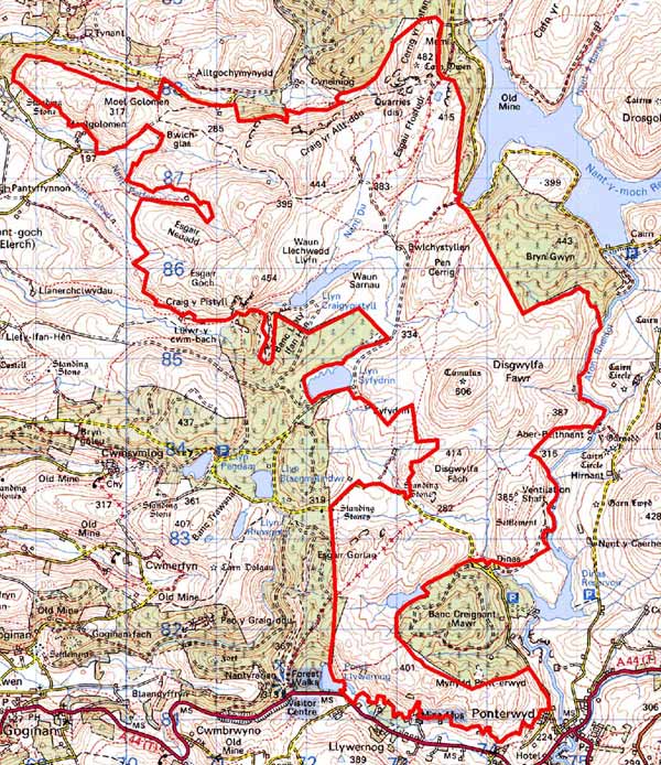
GRID REFERENCE: SN 735847
AREA IN HECTARES: 1850
Historic Background
The extreme southwest corner of this area lay within Cwm-hir Abbey’s Nantyrarian Grange. The remainder has probably always been unenclosed and therefore would have been claimed by the Crown. The Gogerddan estate had acquired part of the grange by at least the end of the 18th century. Estate maps (NLW Gogerddan 71; NLW Vol 37, 47, 49, 55, 56) of that date depict this area as unenclosed sheep-walk with one or two isolated cottages. During the course of the 19th century the southern fringes of this area were divided into very large fields. Running north to south through this area is an ancient road that the estate maps cited above record as the route from Machynlleth to Ffair Rhos. By the mid 19th century the road had virtually disappeared, as George Borrow found to his cost during his walking tour of Wales (Walker 1998, 300). Important metal mines lie towards the northern fringes of this area. Sir Hugh Myddelton worked Hafan mine in the 1720s and Henfwlch mine from at least the early 18th entury. Hafan and Henfwlch Co worked both mines in the mid 19th century. (Bick 1988, 46-48). Production had almost ceased by the end of the 19th century, even though the short-lived Plynlimon and Hafan Tramway linked the mines to the coast in 1897 (Lewis 1998, 178). On the course of the tramway, Bwlchglas mine opened in 1889, and was worked during the early years of the 20th century (Bick 1988, 34).
Description and essential landscape components
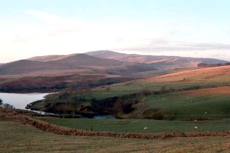
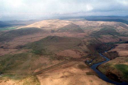
This is an extensive area of unenclosed upland. It includes the craggy peaks and slopes of Disgwylfa Fawr at 507m and the valley sides of the Rheidol down to below 300m. There are no inhabited settlements in the area. Almost the entire area is rough sheep-walk, though on the lower slopes, particularly at the southern limits of the area, there are patches of improved grazing. In these areas relict earth banks of old - 19th century - enclosures are evident. These lower slopes are now generally divided be wire fences. Relict stony banks were also noted at higher levels, some of which seem to be associated with deserted settlements of unknown date. Remains of the lead mining industry on the northern fringes of this area are very impressive components of the historic landscape, and comprise tips, quarries, inclines, adits, buildings and a major tramway. At Bwlchglas concrete foundations testify to the relatively recent date of the workings.
A regular distribution of deserted settlements in the archaeological record indicates a populated area, albeit sparsely, through to the 19th century. Other sites include minor metal mines in addition to the ones mentioned above. A time-depth element to the landscape is provided by several prominent Bronze Age round barrows and by Dinas Iron Age hillfort.
This area possesses fairly clear borders. On many sides it is bounded by modern forestry plantations, and elsewhere by lower lying enclosed and settled land.
Base map reproduced from the OS map with the permission
of Ordnance Survey on behalf of The Controller of Her Majesty's Stationery
Office, © Crown Copyright 2001.
All rights reserved. Unauthorised reproduction infringes Crown Copyright
and may lead to prosecution or civil proceedings. Licence Number: GD272221