Home > Historic Landscape Characterisation > Upland Ceredigion > |

 FRONGOCH
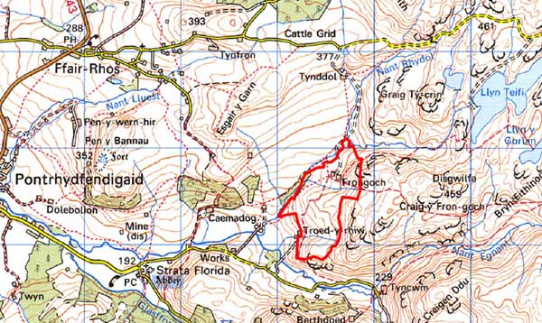
GRID REFERENCE: SN 764664
AREA IN HECTARES: 52.1
Historic Background
In the Medieval Period this area lay within Strata Florida Abbey’s Pennardd Grange. In common with other abbey lands it is likely that by the end of the Medieval Period, if not earlier, Penardd had been divided into farms, which were leased out on a commercial basis. Frongoch is likely to have originated in this manner. Upon the Dissolution the granges were granted to the Earl of Essex. Subsequently, in 1630, they were sold to the Crosswood estate. However, by the 18th century this area had been incorporated into the Nanteos estate. It is likely therefore that Frongoch formed part of the abbey demesne - land that was acquired by John Stedman in 1567 (Cadw 1992) and not by Crosswood - and passed into the Nanteos estate on the death of Richard Stedman in 1746. An estate map of 1819 (NLW Vol 45; 62) shows Frongoch as a holding that consisted of small fields intermixed with those of other farms. Some of these fields are strip-like. It seems likely therefore that this landscape evolved from a subdivided field system, perhaps upland shared pasture rather than arable land. By the tithe survey all evidence of this had gone (Gwnnws Tithe Map and Apportionment, 1847).
Description and essential historic landscape components
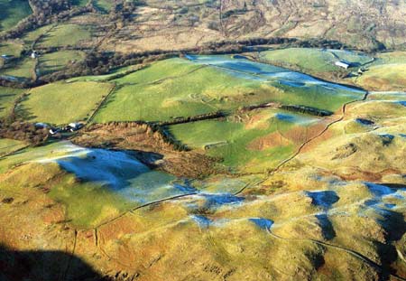
A small, isolated landscape area on high, gentle west and southwest-facing slopes above the upper reaches of the Afon Teifi lying between 220m and 350m. It is centred on the farm of Frongoch and consists of a block of improved grazing separated into small- to medium-sized fields. Old boundaries to the fields comprise earth banks. No hedges are now present and wire fences run along most of the banks. Frongoch is a typical regional 19th century Georgian vernacular farmhouse with a couple of ranges of stone outbuildings and very extensive modern outbuildings.
The recorded archaeology consists of a settlement of Medieval or post-Medieval date.
The boundaries of this area are well defined. To the northeast, east and south of this area lies a large tract of high, unenclosed moorland. Rough grazing land in large enclosures and open moorland lies to the northwest, and to the southwest the land falls rapidly away to the enclosed land of the valley floor.
Base map reproduced from the OS map with the permission
of Ordnance Survey on behalf of The Controller of Her Majesty's Stationery
Office, © Crown Copyright 2001.
All rights reserved. Unauthorised reproduction infringes Crown Copyright
and may lead to prosecution or civil proceedings. Licence Number: GD272221