Home > Historic Landscape Characterisation > Upland Ceredigion > |

 LLAWR-Y-CWM-BACH
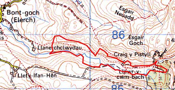
GRID REFERENCE: SN 702856
AREA IN HECTARES: 43.6
Historic Background
The history of this area has not been researched. Until two centuries ago much of the land was unenclosed and was therefore probably claimed by the Crown. By at least the late 18th century part of the area lay within the Court Grange estate, as an estate map (NLW Vol 38, 16) shows Llawr-y-cwm farm on the south side of the valley as an isolated holding of four fields set in a sea of unenclosed land or sheep-walk. The tithe map (Llanbadarnfawr 1845) shows Llawr-y-cwm, Llawr-y-cwm-bach and Ty-hen farms with small enclosures along the valley floor, and very large enclosures on the valley sides. There has been an abandonment of settlement since then, with just Llawr-y-cwm-bach surviving. Llawr-y-cwm-bach metal mine does not seem to have been of any significance until 1845 (Bick 1988, 32), though workings through the second half of the 19th century appear to have been considerable.
Description and essential historic landscape components
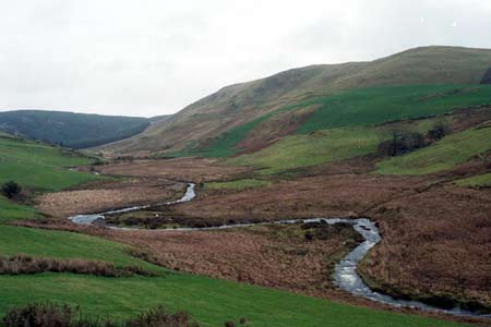
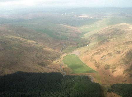
This area consists of the valley floor and lower valley sides of the upper Afon Leri, located at between 240m and 300m. To the north, south and east the valley sides rise steeply to over 400m. Only a single farm now survives; a stone-built structure with stone outbuildings. The deserted remains of another farm and long abandoned cottages testify to the formerly more populated nature of the area, and are obvious components of the historic landscape. Field patterning consists of small- to medium-sized irregular enclosures on the valley floor and lower slopes, with larger enclosures above. Boundaries are composed of earth or earth and stone banks - there are no hedges. However, this field patterning is now largely redundant and wire fences provide the few boundaries across a landscape of improved grazing. Though improved grazing dominates, there are rushy and peaty hollows on the valley floor and rougher grazing on some of the steeper slopes. Towards the head of the valley spoil heaps testify to the once active metal mining industry. Other remains comprise an engine house, ore slide, buddle circle and leat. Apart from trees close to the farm and mine, this is essentially a treeless landscape.
The recorded archaeology consists of the deserted settlements mentioned above and the remains of the metal mining industry.
This area is well defined to the north, south and east where unenclosed and semi-enclosed land rises steeply from the valley floor. To the west the boundary between this area and its neighbour is less clear and not so well defined.
Base map reproduced from the OS map with the permission
of Ordnance Survey on behalf of The Controller of Her Majesty's Stationery
Office, © Crown Copyright 2001.
All rights reserved. Unauthorised reproduction infringes Crown Copyright
and may lead to prosecution or civil proceedings. Licence Number: GD272221