Home > Historic Landscape Characterisation > Upland Ceredigion > |

 LLUEST
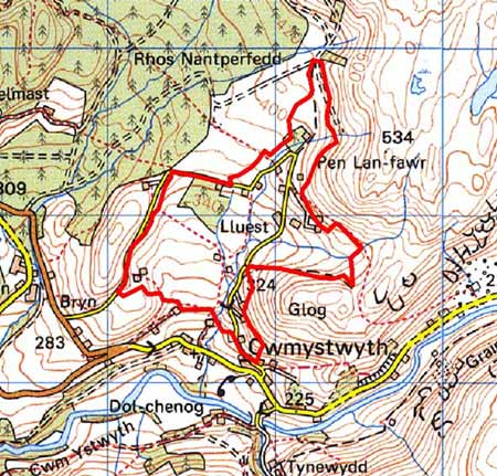
GRID REFERENCE: SN 787750
AREA IN HECTARES: 95.4
Historic Background
This area lay within Strata Florida Abbey’s Cwmystwyth Grange. Upon the Dissolution, its unenclosed character ensured that the Crown claimed it. In the late 18th and early 19th century squatters began to occupy portions of this unenclosed Crown land. Part of the land was subjected to an Enclosure Act of 1860 (Chapman 1992, 53). The map drawn up for the award (NLW Card CC Deposit 6) depicts the encroachments made upon Crown land by the squatters. Those that had been in occupancy for more than 20 years were granted freehold; those less than 20 years were given the option to purchase their holdings. It is clear that the squatters were partially dependant for their livelihood on employment in the metal mining industry. Decline in the industry had a concomitant affect on these settlements, and the 20th century has witnessed widespread desertion. However, in recent decades many of the houses have experienced an upturn in fortune, and have been renovated or rebuilt.
Description and essential historic landscape components
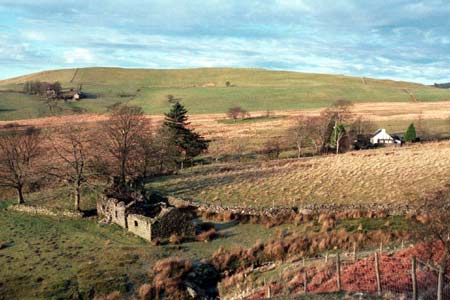
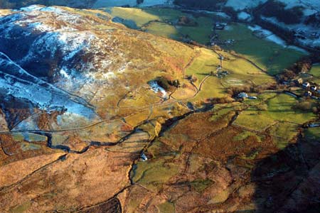
This area comprises the high open upland valley of the Nant Gorlan lying between 280m and 400m. Buildings of the dispersed settlement pattern comprise smallholdings, cottages and houses. Local stone is the traditional building material, which is usually cement rendered on houses, with slate (north Wales slate) used for roofs. Dwellings almost entirely date to the mid-to-late 19th century, are relatively small, of one or two storeys and in the typical Georgian vernacular style – gable end chimneys, central front door, and two windows either side of the door and one above – but generally vernacular traits are present, such as low eaves, small windows and one chimney larger than the other. Many houses have been extensively modernised or rebuilt. Several ruined houses are present. Where present stone-built outbuildings are generally confined to one or two small ranges, with some attached and in-line to the house. There are very few modern farm buildings, and where present they are quite small.
Annexed to the dwellings are small paddocks or fields, usually of improved grazing. Dry-stone walls provide the boundaries between fields, but earth banks and stony banks are also present. Many of these older boundaries are now redundant and wire fences have replaced them. There are several deserted cottages in this area, and the sites of several more are evident. Between settlements the landscape is one of unenclosed very rough grazing, with rushy and peaty land in hollows. Small conifer plantations have been established across the centre of the area, but apart from these and occasional trees close to dwellings, this is essentially a treeless landscape. There are minor remains of the metal mining industry - tips and levels - on the eastern side of this area.
Apart from extant and abandoned dwellings, and the remains of the metal mining industry, the only other significant archaeological site in this area is a possible Bronze Age ring barrow.
This is a distinctive area, though its boundaries are not sharp. To the north and east lies high unenclosed moorland, and to the south and west lower-lying enclosed farmland.
Base map reproduced from the OS map with the permission
of Ordnance Survey on behalf of The Controller of Her Majesty's Stationery
Office, © Crown Copyright 2001.
All rights reserved. Unauthorised reproduction infringes Crown Copyright
and may lead to prosecution or civil proceedings. Licence Number: GD272221