Home > Historic Landscape Characterisation > Upland Ceredigion > |

 LOWER RHEIDOL VALLEY
GRID REFERENCE: SN 672788
AREA IN HECTARES: 268.1
Historic Background
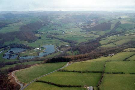
The early history of this area has not been researched. By the 18th century at least part of the area lay within the Nanteos estate. 1819 estate maps (NLW Vol 45, 16, 17, 18) show that a dispersed settlement pattern and system of small irregular fields had been established. It is likely that the settlement pattern is relatively ancient, dating to at least the later Medieval Period. It is not known how the field system evolved. The origin of the small loosely nucleated settlement of Aberffrwd was probably dependent on the metal mining industry. A chapel was constructed here in 1756, and a school room shortly after (Percival 1998, 518). Two post-Medieval mills lie within the area. Opencast gravel working was carried out in the 20th century, and the pits have now been restored and converted to fishing lakes.
Description and essential historic landscape components
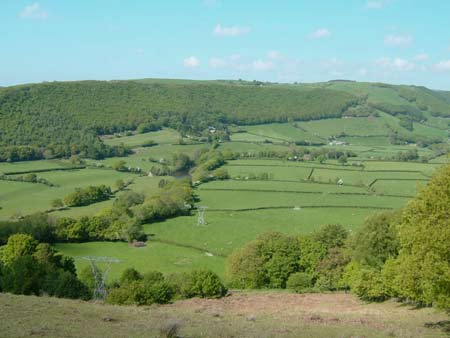
This area comprises the valley floor at approximately 50m and the un-wooded lower sides of the Rheidol up to 100m. The field pattern is one of small irregular enclosures divided by earth banks topped with hedges. Hedges are generally in good condition, although approximately 20% are overgrown or otherwise neglected, and wire augments most hedges. All land is enclosed. Improved grazing dominates, with very little rough ground. Metal mine remains are evident close to Aberffrwd. Former gravel workings at the western end of the area have been restored and are now used for recreational purposes.
The settlement pattern is of dispersed farms, with most dwellings located towards the foot of the valley sides. A small, loosely nucleated settlement at Aberffrwd consists of a chapel, school and mainly 19th century dwellings. Local stone is the traditional building material with slate (north Wales slate) used for roofs, although some late 19th century houses are brick-built. Walls are either cement rendered, painted or left bare on houses, and are always bare stone on traditional farm buildings. However, traces of whitewash are evident on some farm buildings, and careful examination shows that some are built of river cobbles rather than the more common quarried stone. Older farmhouses/houses almost entirely date to the mid-to-late 19th century, are relatively small, of two storeys and in the typical Georgian vernacular style, with gable end chimneys, central front door, and two windows either side of the door and one above. One substantial late 19th century gothic style stone-built house with brick details is present. There are a few modern houses, particularly close to the old gravel pits. Stone-built outbuildings are generally confined to one or two small ranges. Several farms are not now working and their outbuildings are not in use. Working farms generally have small ranges of modern steel and concrete agricultural buildings, although a couple of farms with very large modern agricultural buildings are present. A number of detached modern agricultural buildings are recorded.
The recorded archaeology of this area consists mostly of post-Medieval industrial remains, including the metal mine mentioned above, and two mills. Prehistoric finds provide some time-depth to the landscape.
This area is very well defined to the north and south by deciduous and coniferous forestry. To the east the Rheidol valley is characterised by industry, past and present, rather than the agriculture of this area, only to the west is the boundary blurred between this area and its neighbour.
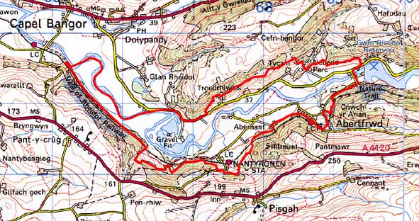
Base map reproduced from the OS map with the permission
of Ordnance Survey on behalf of The Controller of Her Majesty's Stationery
Office, © Crown Copyright 2001.
All rights reserved. Unauthorised reproduction infringes Crown Copyright
and may lead to prosecution or civil proceedings. Licence Number: GD272221