Home > Historic Landscape Characterisation > Upland Ceredigion > |

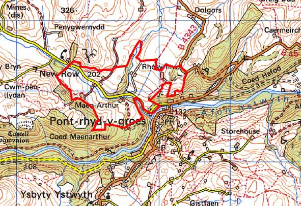
 MAEN ARTHUR
GRID REFERENCE: SN 734730
AREA IN HECTARES: 104.2
Historic Background
Maen Arthur was not part of a grange of Strata Florida Abbey and its early history is unknown. By the 16th century it was referred to as an ‘ancient demesne’ or a ‘township’ (Macve 1998, 62). In 1586, it was purchased by Morris ap Richard of Trawscoed. A folk-tale related by Morgan (1977, 34-35) tells that Morris tricked the ladies who owned Maen Arthur out of it. A lease of 1654 of Maen Arthur records that cattle and sheep were kept and crops raised. A corn mill and a tucking mill are recorded at Maen Arthur from 1566, and in 1608 in addition to the corn mill a smelting mill is noted (Macve 1998, 62-65). There is no mention of the corn mill after 1762; by 1760 the Crosswood estate had decided to close down smaller mills and concentrate milling at Wenallt. A 19th century woollen factory lies on the border of this area at Pontrhydygroes.
Tithe maps (Llanafan and Llanfihangle y Creiddyn) show a similar field and settlement pattern to today, though there has been some loss of settlement.
Description and essential historic landscape components
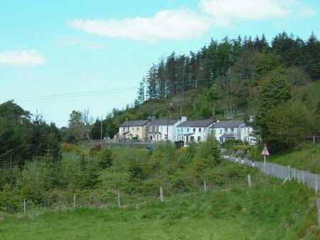
This small landscape area lies on the banks of the Nant Cell, a small, steeply descending, south and southeast-flowing stream. The banks of the lower course of the stream are heavily wooded, but at higher levels this area comprises gentle valley sides of improved pasture, though there are patches of rougher grazing and peat deposits in hollows. The valley bottom in the extreme southeast of the area lies at 130m; higher slopes achieve heights of 230m. The settlement pattern is one of scattered farms set in a field system of small, irregular enclosures. Boundaries are earth banks topped with hedges. Hedges are in fair to good condition, but are tending towards the overgrown and in some instances are neglected. Wire fences supplement most hedges. The remains of two small metal mines lie within this landscape area.
Local stone is the traditional building material with slate (north Wales slate) used for roofs. Farmhouses probably date to the mid 19th century, but are generally modernised. Farms have a couple of ranges of stone outbuilding and extensive modern agricultural buildings. A few modern houses are included in this area as well as New Row, a line of mid- to-late 19th century semi-detached vernacular worker cottages, most of which are modernised.
The recorded archaeology of the area is varied. Finds of Bronze Age date provide time-depth to the landscape, but most recorded sites are of post-Medieval date and include mills, metal mining remains and the sites of chapels.
The borders of this area are well defined. Forestry and woodland lie to the south and east, while higher ground comprising large enclosures lies to the west and north.
Base map reproduced from the OS map with the permission
of Ordnance Survey on behalf of The Controller of Her Majesty's Stationery
Office, © Crown Copyright 2001.
All rights reserved. Unauthorised reproduction infringes Crown Copyright
and may lead to prosecution or civil proceedings. Licence Number: GD272221