Home > Historic Landscape Characterisation > Upland Ceredigion > |

 MOELGOLOMEN
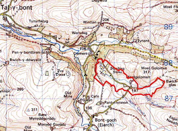
GRID REFERENCE: SN 694875
AREA IN HECTARES: 76.2
Historic Background
The history of this small historic landscape area has not been researched. It is likely that settlement in this valley is long established. The earliest large-scale map of the area, the tithe map of 1845 (Llanbadarnfawr parish), shows a landscape of small farms and cottages set in a field system of small, irregular enclosures. This map illustrates the high density of settlement reached during this period, a density that has since diminished. A small metal mine was worked here from 1850 for several decades, but does not seem to have been particularly successful (Bick 1988, 34).
Description and essential historic landscape components
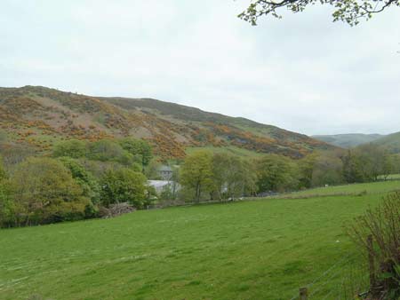
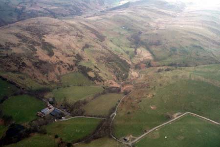
This is a small but nevertheless distinct and varied historic character area. It is centred on the farm of Meolgolomen – a mid-to-late 19th century vernacular Georgian house with stone outbuildings and substantial modern agricultural buildings. A second farm has a modernised house with fewer outbuildings. Several deserted and ruined farms and cottages testify to the once more populous nature of this area. The field pattern is one of small irregular enclosures, whose boundaries comprise earth or earth and stone banks topped with hedges. Hedges are in fair condition close to the farm, but are overgrown and neglected elsewhere. Wire fences supplement all boundaries. Some hedgerows possess distinctive trees, and these, together with small stands of deciduous woods and coniferous plantations, lend a wooded appearance to the landscape. Farmland is of improved grazing with rushy and peaty hollows, and rougher ground and bracken on some steep slopes. Spoil tips and other remains at the eastern end of the area mark the location of a small metal mine. Leats, presumably serving mines at lower levels in neighbouring areas cross this landscape.
The recorded archaeology consists of the remains of metal mines and other post-Medieval elements of the landscape. A time-depth component is provided by two Bronze Age standing stones and by finds of Bronze Age date.
It is difficult to define the exact boundary between this area and those to the south and west, as they share many similar characteristics, though overall they are different. There is no such problem to the north and east, where unenclosed upland bounds this area.
Base map reproduced from the OS map with the permission
of Ordnance Survey on behalf of The Controller of Her Majesty's Stationery
Office, © Crown Copyright 2001.
All rights reserved. Unauthorised reproduction infringes Crown Copyright
and may lead to prosecution or civil proceedings. Licence Number: GD272221