Home > Historic Landscape Characterisation > Upland Ceredigion > |

 MYNYDD MARCH
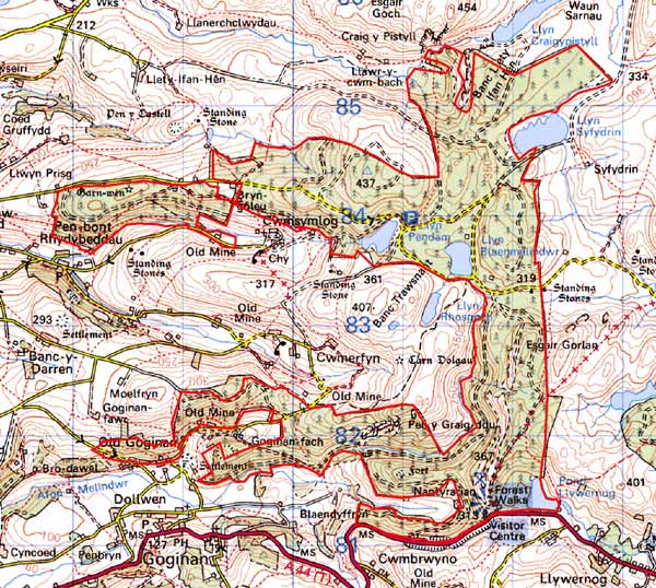
GRID REFERENCE: SN 719832
AREA IN HECTARES: 741.4
Historic Background
In the Medieval Period, the southern part of this area lay within the Nantyrarian Grange of Cwm-hir Abbey, while part of the northern extent lay within Strata Florida’s Y Dywarchen Grange (Williams 1990, 41, 57). Following the Dissolution the granges seem to have been divided between several incipient estates, with most land acquired by the Gogerddan estate. The upland, unenclosed character of much of this area however, probably ensured that the Crown claimed it, until appropriated by Gogerddan in the 18th or 19th century. Estate maps dating to the late 18th century (NLW Gogerddan 68, 70; Vol 37, 37, 57, 60, 64, 66) show this area as unenclosed moorland or sheep-walk, although two isolated cottages - Lluest Trafle - are shown to the north of Cwmsymlog and two further isolated cottages shown to the west. The status of these settlements is unclear; the lluest name may indicate an ancient but perhaps originally seasonal occupation, but all may well be 18th century squatter cottages. In the 19th century parts of the lower-lying western fringes of this area were subjected to enclosure and divided into very large fields, but the overall unenclosed character was probably maintained. Some old deciduous woodland was recorded on steep slopes above Nantyrarian in the 19th century, and metal mining, though mainly concentrated in the valleys below, occurred here. Level Newydd was a small operation worked in the mid 19th century, and facilities connected with Bwlch Cwmerfyn mine lie within this area (Bick 1983, 44). Reservoirs were also constructed to serve mines at lower levels. The whole area was acquired by the Forestry Commission and planted with conifers. The earliest plantings were within the older woodland blocks and on steep slopes in the northern part of the area. Later, during the 1960s, planting took place on higher ground.
Description and essential historic landscape components
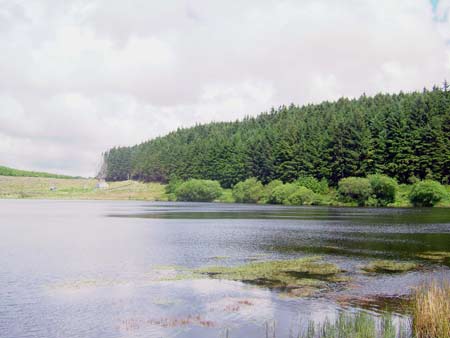
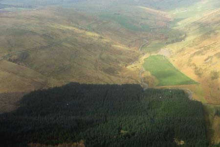
This area is entirely covered by forestry plantations. It comprises undulating, on occasions craggy, upland which achieves a maximum height of over 390m, but at its western end, on the lower sides of valleys, runs down to less than 250m. The average height is between 300 and 400m. Prior to afforestation almost all of this area comprised unenclosed moorland, but map sources indicate that several cottages were present, sometimes with one or two adjacent small fields. At least one cottage survives – a typical regional late 19th century two storey rendered stone structure. Tips and shafts, the remains of metal mining, occur in the southern part of this area, to the south of Cwmerfyn. Two reservoirs constructed to serve the metal mining industry - Llyn Pendam and Llyn Blaenmelindwr - are dramatic components of the historic landscape within this wooded environment. Further metal mining remains lie close to these reservoirs. However, it is the plantations, tracks, roads and other forestry features that are the most common and prominent historic landscape components in this area.
In addition to the large numbers of mining remains in the archaeological record, deserted settlements indicate a moderately populated area until the 19th century. Time depth to the landscape is provided by an Iron Age fort and several Bronze Age standing stones, including a stone pair.
This forested area is well defined. To the east, north, south and part of the western side lies high, unenclosed moorland, with some improved land bordering part of the eastern side. On much of the western boundary lies lower-lying enclosed and settled land.
Base map reproduced from the OS map with the permission
of Ordnance Survey on behalf of The Controller of Her Majesty's Stationery
Office, © Crown Copyright 2001.
All rights reserved. Unauthorised reproduction infringes Crown Copyright
and may lead to prosecution or civil proceedings. Licence Number: GD272221