Home > Historic Landscape Characterisation > Upland Ceredigion > |

 NANT-Y-MOCH
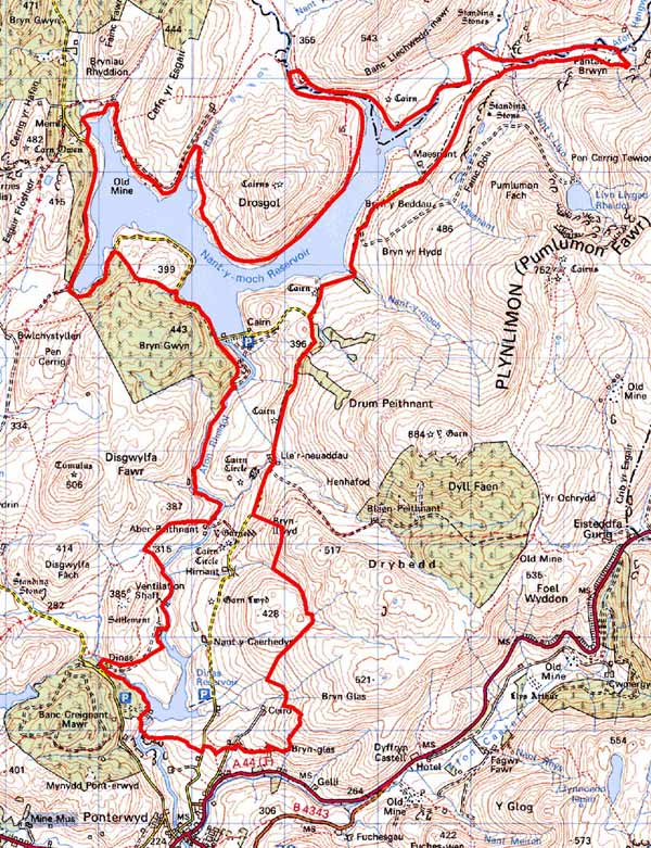
GRID REFERENCE: SN756855
AREA IN HECTARES: 952.2
Historic Background
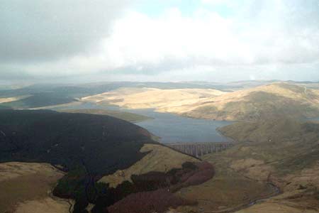
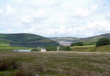
The early history of this area has not been researched, however, as it was unenclosed land the Crown would have claimed much of it. By the late 18th century, land on the lower slopes and the valley floor is recorded as farms on Gogerddan and Nanteos estate maps. The date of the foundation of these farms is unclear, they may be of some antiquity, or of more recent date; the result of encroachment on unenclosed land. It is also unclear how they came into the possession of the Gogerddan and Nanteos estates. The estate maps of the late 18th and early 19th century (NLW R.M. C21; NLW Vol 45, 24; NLW Vol 37, 37) show typical upland farms - Camddwr Mawr, Camddwr Bach, Maesnant, Nant Llyn, Nant Caerhedyn and Nant Hirnant. These are isolated farms with one or two small adjacent fields set in vast tracts of open sheep-walk. During the 19th century sheep-walk on the lower slopes was divided into large fields. In 1865, a Calvinistic Methodist church was established at Blaenrheidol to serve the community, but was relatively short-lived as in 1964 it was submerged beneath the waters of Nant-y-Moch reservoir. Nant-y-Moch reservoir forms part of the Rheidol hydroelectric scheme, and its waters and dam, together with those of Dinas reservoir lower down the valley, form a dramatic component to the landscape.
Description and essential historic landscape components
This area consists of part of the upper Rheidol valley. The river descends through this area in a series of cataracts from a high point of 400m at its northern end down to 240m at its southern end. The rivers flow has been interrupted by the construction of two dams for the Rheidol hydroelectric scheme in 1964. The upper and more massive of the two contains the extensive Nant-y-Moch reservoir, the lower - Dinas - retains a more modest body of water. Both reservoirs are dramatic and important elements of the historic landscape. Adjacent to Dinas are buildings and car parks of the hydroelectric scheme. This landscape of power generation is superimposed over an agricultural landscape of hill farms. Farms are widely dispersed and are traditionally stone-built with cement render under slate roofs. Typically farmhouses are two-storey, small and date to the mid-to-late 19th century. They are in the regional Georgian vernacular style - gable end chimneys, central front door, and two windows either side of the door and one above. One or two of these houses have been completely rebuilt or heavily modernised. One or two ranges of stone farm outbuilding, with some in-line and attached to the house, are present on most farms, as are medium-sized modern agricultural buildings. Deserted farms and cottages are also present. The field pattern comprises large enclosures divided by earth and stony banks with occasional dry-stone walls. At lower levels derelict hedges lie on some of the banks, but most boundaries are now redundant, and the enclosures are divided by wire fences. Rough grazing is the dominant land-use, with improved grazing close to farms and on some moderate- to steep-slopes. Most gently sloping or level land is under rushy, peaty-ground. It is essentially a treeless landscape.
The recorded archaeology in this area is rich and varied. Numerous remains of deserted settlements indicate a more populated landscape through to the 19th century. Minor agricultural features including clearance cairns and boundary walls or banks are often associated with these settlements. Remains of metal mines are also common, particularly on the northern boundary. Bronze Age barrows/cairns and many other possible sites - often occurring in groups -, possible standing stones and finds of prehistoric date indicate a settled landscape 3000-4000 years ago, but the only direct evidence for occupation are two burnt mounds or hearths.
Apart from the south where this area borders the lower lying and more settled land of Ponterwyd, this area is bounded by modern forestry or unenclosed upland. The boundary between this area and unenclosed upland is not clear, and is probably in a constant state of flux as the limits of improved grazing are pushed higher up the hillsides.
Base map reproduced from the OS map with the permission
of Ordnance Survey on behalf of The Controller of Her Majesty's Stationery
Office, © Crown Copyright 2001.
All rights reserved. Unauthorised reproduction infringes Crown Copyright
and may lead to prosecution or civil proceedings. Licence Number: GD272221