Home > Historic Landscape Characterisation > Upland Ceredigion > |

 NANTYRARIAN
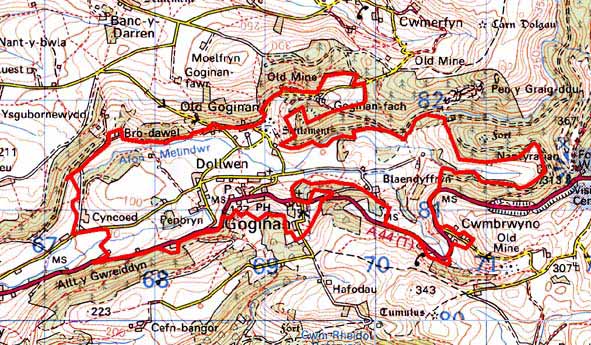
GRID REFERENCE: SN 693813
AREA IN HECTARES: 320.0
Historic Background
The eastern portion of this area, east of Goginan village, lay within the Nantyrarian Grange of Cwm-hir Abbey. This was an important pastoral holding; 300 sheep, 128 cows and 26 mares are recorded here in 1291 (Williams 1990, 40). Lewis Morris surveyed the extent of the ‘Lordship of Nantyrarian’, which was probably coterminous with the grange. Morris was mainly concerned with metal mining and the location of lead-silver ores, but his map of 1744 shows a landscape of dispersed farms. By the 18th century, the Gogerddan and Powis Castle estates owned most of the property in the area. Estate maps of the late 18th century (NLW Powis Castle 164; NLW Vol 37, 57-60) show Ty’n-y-pwll, Nantyrarian, Cwmbrwyno, Abernant-yr-arian and Blaendyffryn farms in a landscape of small, valley-floor enclosures - a landscape very similar to todays. It is likely that by the later Middle Ages, or perhaps earlier, Nantyrarian Grange had been divided into farms which were leased out and farmed separately. The farms recorded by Morris and shown on the estate maps therefore may be of some antiquity, as may their associated field systems. Lead mining has long been an important element in the economic fabric of the area. Roman artefacts reputedly from workings may testify to the antiquity of the Goginan mine (Bick 1983, 35-38; Hughes 1988). Goginan was certainly worked from the 1560s until the 20th century. Other mines in the area include West Goginan and Ty’n-y-Pwll. The richness and longevity of the Goginan mines has had a dramatic effect on the historic landscape. In addition to the mine workings, worker houses, chapels and other buildings at Old Goginan, Goginan and Cwmbrwyno attest to the wealth generated by the industry. The construction of a turnpike road through the area - now the A44 - further increased the commercial potential of the area, and led to a change in focus of settlement within the area from Old Goginan on the valley floor to Goginan on the new road, and determined the location of the mining community of Cwmbrwyno.
Description and essential historic landscape components
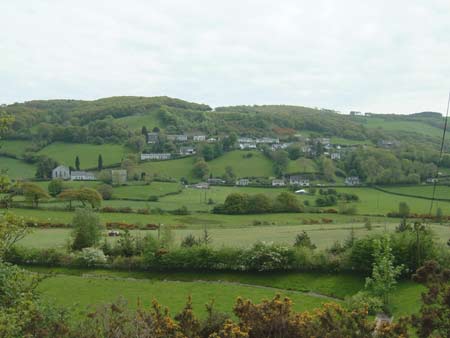
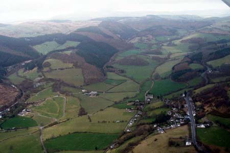
This complex area is centred on the flat-bottomed, rich valleys of the Arian, Melindwr and Brwyno. Heavily wooded valley sides rise steeply, achieving heights of 300m, from valley floors located at c. 100m. The wooded valley sides are not included in this area, but the lower slopes where they are free of trees, up to approximately 200m, are. Farmland is almost entirely of improved grazing, with very little rough ground. Small, irregular enclosures lie across the valley floor and up the lower slopes. The boundaries of this field system comprise earth banks topped with hedges. Hedges alongside roads are in good condition and are well maintained, but elsewhere they are in poor condition, are sometimes overgrown or becoming derelict, and are augmented by wire. At the east and west ends of the area are distinctive hedgerow trees, and these together with occasional small stands of broadleaves, and the heavily afforested valley sides lend a wooded appearance to certain locations.
The ancient settlement pattern of dispersed farms is overlain by 18th and 19th century mining communities and modern development. Buildings, both agricultural and industrial are traditionally stone-built (bare stone, cement rendered or painted stone) with north Wales slate roofs. Goginan is the largest of the industrial settlements, although it is still just a village, and consists of terraces of worker houses (purpose built single phase terraces as well as multi-build terraces) in the typical late 19th century Georgian vernacular tradition of the region. There are also detached and semi-detached worker houses in a similar style, larger Georgian or Georgian style houses - probably mine manager or owner houses -, a public house in the Georgian style and several 19th century chapels and a church, now disused. The whole village is dispersed along and down-slope of the turnpike road (the present main road). On the slopes below this older village core are late 20th and 21st century houses and bungalows. On the opposite valley side, on south-facing slopes, the housing is detached or semi-detached and larger than that found in Goginan, although of a similar style and date; perhaps houses for supervisors or managers. There are also some smaller worker houses here. Worker houses are also present at Cwmbrwyno as well as a late 19th century gothic villa. Farms are of a mixed size, but tend towards the small- and medium-size. Farmhouses are in the typical mid-to-late 19th century Georgian vernacular style, usually two storey, and of cement rendered stone. Stone built out buildings are of a similar date and usually consist of two or three small ranges. Some farms have the outbuildings attached and in-line to the house. Modern agricultural buildings are present on working farms, but are generally not large. Scattered across the landscape are modern houses and bungalows, with clustering close to Old Goginan and Goginan.
Spoil tips comprise the most obvious remains of the lead mining industry. Those of the Goginan mine have been subject to a programme of environmental improvements and little of interest now survives of these and any other components of the site apart from an inclined plane.
Most of the recorded archaeology of this area consists of remains of the metal mining industry and extant post-Medieval buildings such as chapels, dwellings and a school. However, finds of Neolithic date, two Bronze Age round barrows, a possible Bronze Age standing stone and an Iron Age hillfort provide time-depth to the landscape.
The boundaries of this area are well defined on all sides
apart from towards the eastern end where lower lying enclosed land around
Capel Bangor merges with it. On all other sides this area is bordered
by heavily wooded valley sides or by high moorland.
Base map reproduced from the OS map with the permission
of Ordnance Survey on behalf of The Controller of Her Majesty's Stationery
Office, © Crown Copyright 2001.
All rights reserved. Unauthorised reproduction infringes Crown Copyright
and may lead to prosecution or civil proceedings. Licence Number: GD272221