Home > Historic Landscape Characterisation > Upland Ceredigion > |

 PENGROGWYNION AND BRYNAFAN
GRID REFERENCE: SN 718729
AREA IN HECTARES: 122.4
Historic Background
The history of this area has not been researched. By the mid 18th century Pengrogwynion farm, which constitutes the majority of this area, was in the possession of the Gogerddan estate, though the Trawscoed estate held surrounding land. It is not certain how these estates acquired the land. A folk-tale related by Morgan (1977, 35) tells how the Vaughans of Crosswood lost Pengrogwynion to Gogerddan when gambling in a tavern on a race between two flies. Late 18th and early 19th century estate maps (NLW Crosswood Vol 1, 22; NLW Gogerddan 54 and 55) show small, irregular fields close to the farmstead of Pengrogwynion with larger enclosures and patches of unenclosed land further out - the greatest portion of the land was unenclosed. Cottages, sometimes within enclosures or paddocks, are shown scattered across the area of large enclosures and unenclosed land. This settlement pattern of dispersed cottages is of interest. It is almost certainly the result of late 18th or early 19th century squatting. The main core of the settlement at over 300m would have been situated on marginal land, and this, together with employment opportunities offered by the nearby Grogwynion and Gwaithgoch lead mines, made it an ideal location for squatters. Contemporary estate maps indicate that the land on which the squatters settled was unenclosed, but owned by, or at least claimed by, the Crosswood estate, and was not Crown common. By the tithe survey of 1845 (Llanafan tithe map and apportionment) the status of the squatters had been formalised and they were now tenants of the Crosswood estate. By 1845 the number of cottages had increased, though by this date their maximum extent had passed, for instance a former cottage is marked ‘Site of House’ on the map. Modern maps indicate that there has been considerable subdivision of the larger enclosures since the tithe survey. Grogwynion lead mine, located in the historic landscape area to the north had little direct influence on this area.
Description and essential historic landscape components
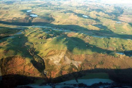
An undulating area with craggy outcrops above the north side of the Ystwyth valley, with a height range of 240m to 350m. Most of the land is given over to improved grazing, but there are tracts of rough grazing, rushes and peaty hollows, and it a treeless landscape. A distinctive element of the landscape is the dispersed settlement pattern consisting of cottages and houses and smallholdings. Older buildings are of local stone (cement rendered and painted stone) with slate roofs. At Brynafan there is a loose cluster of small mid-to-late 19th century single storey vernacular cottages, but most have been modernised and extended and their original form is not obvious. Smallholding dwellings are probably of a similar date, and of two storeys with strong vernacular traits, rather than Georgian elements, which are more common in this region for the period. One of these houses is listed. Stone built farm buildings are small, probably sufficient for a couple of cows and storage. Modern agriculture buildings, where present, are also small.
The field pattern is mixed, comprising small irregular fields and larger more regular enclosures. Boundaries are of earth banks, with hedges only present on the lower slopes at the eastern end of the area. These hedges are in poor condition and supplemented with wire fences. Elsewhere wire fences sit on top of the earth banks.
Castell Grogwynion, a fine example of an Iron Age hillfort is located at the eastern end of this character area. The only other recorded archaeology consists of a chapel/Sunday school, built in 1905.
The borders of this area are well defined on three sides
with a steep valley side and lead mining area to the south, and forestry
to the west and east. To the north the boundary is less clear.
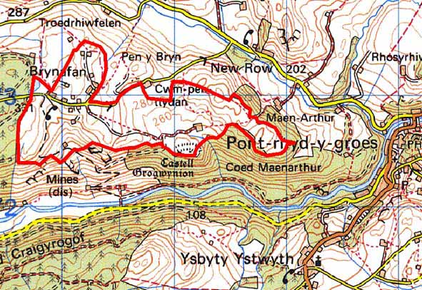
Base map reproduced from the OS map with the permission
of Ordnance Survey on behalf of The Controller of Her Majesty's Stationery
Office, © Crown Copyright 2001.
All rights reserved. Unauthorised reproduction infringes Crown Copyright
and may lead to prosecution or civil proceedings. Licence Number: GD272221