Home > Historic Landscape Characterisation > Upland Ceredigion > |

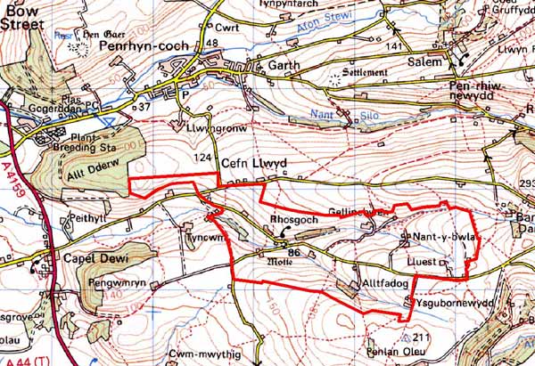
 RHOSGOCH
GRID REFERENCE: SN 654824
AREA IN HECTARES: 233.8
Historic Background
This historic landscape area lies on the edge of the current study area and has not been fully defined. No research on its history has been undertaken. The only estate map of the area (NLW Scott Archer 20) dates to 1788, and shows a landscape of scattered farms and a field system of small irregular enclosures. This pattern had not changed by the tithe survey. Indeed it is only in recent decades that major alterations to the landscape have occurred, with modern linear development close to Cefn Llwyd. Although there is no evidence to support the suggestion, it is possible that the settlement pattern of dispersed farmsteads, and the field system of small irregular enclosures date to at least the late Medieval Period.
Description and essential historic landscape components
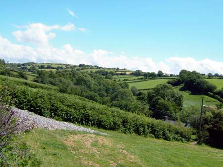
This area comprises the upper valley of the Afon Peithyll; an east-west flowing stream. The valley floor lies at about 90m; the rounded valley sides and slopes rise to over 200m. Stands of deciduous woodland, particularly on the lower valley sides and valley bottom, together with occasional distinctive hedgerow trees, lend a wooded aspect to the landscape. Improved grazing dominates with very little rough ground present. Field patterning consists of small irregular enclosures divided by earth banks topped with hedges. Hedges are in fair to good condition at lower levels, poorer on the higher slopes where some are becoming derelict, and all hedges are augmented with wire fences.
The settlement pattern is of dispersed farms. Stone with slate for roofs are the traditional building materials. The wall treatment is bare stone or cement render on houses and bare stone on traditional outbuildings. Farmhouses are small and in the regional late 19th century vernacular tradition – gable end chimneys, central front door, and two windows either side of the door and one above. At least one house has been substantially modernised. Stone-built outbuildings are generally confined to two or three small- to medium –sized ranges. There is at least one outbuilding of yellow brick. Working farms have substantial ranges of modern steel and concrete agricultural buildings. A 19th century chapel and chapel house are located in this area. Modern linear development comprising concrete and brick-built dwellings is currently under construction close to Cefn Llwyd.
Recorded archaeology consists mainly of post-Medieval sites. These include three mills, or the sites of three mills, extant cottages and farmhouses and metal mines. The only time depth to the landscape is provided by a small Medieval motte - Ystrad Peithyll. This small English castle was destroyed in 1113.
There is a clear boundary between this area and its neighbours
to the north, east and south, where ridges of 18th and 19th century enclosure
and few settlements are found. Historic landscape areas to the west have
yet to be defined.
Base map reproduced from the OS map with the permission
of Ordnance Survey on behalf of The Controller of Her Majesty's Stationery
Office, © Crown Copyright 2001.
All rights reserved. Unauthorised reproduction infringes Crown Copyright
and may lead to prosecution or civil proceedings. Licence Number: GD272221