Home > Historic Landscape Characterisation > Upland Ceredigion > |

 TANYFFORDD
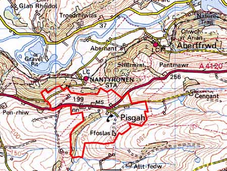
GRID REFERENCE: SN 676774
AREA IN HECTARES: 101.6
Historic Background
As with neighbouring areas, the early history of this area has not been researched, but by the 18th century it formed part of the Nanteos estate. Estate maps of 1819 (NLW Vol 45; 19, 32, 33, 40) show a landscape of dispersed farms, small, irregular enclosures close to farmsteads, larger enclosures further out and a small quantity of unenclosed land. By the tithe survey some of the very small fields had been amalgamated and the larger fields sub-divided, resulting in a landscape very similar to that of today. Since the tithe survey a small, nucleated settlement has formed at Pisgah.
Description and essential historic landscape components
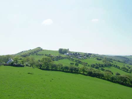
This small undulating area ranges in height from 180m to 240m and comprises mostly improved grazing with deciduous woodland on steep slopes. Small, irregular enclosures characterise the field pattern, and earth banks with hedges divide the fields. Hedges are generally in fair to good condition, but on higher ground they are becoming derelict and some have been replaced with wire.
The A4120 runs through the area; this was a former turnpike and the main road to the east from northern Ceredigion prior to the construction of a new turnpike - the present A44 - in 1829.
The settlement pattern is one of dispersed farms with a small linear settlement at Pisgah. Traditional houses are built of stone, which is either left bare, painted or cement rendered, and they have slate roofs. Older houses are small, mostly two storey, although at least one one-storey cottage is present, and date to the mid-to-late 19th century. They are in the typical Georgian vernacular style – gable end chimneys, central front door, and two windows either side of the door and one above. Most houses have strong vernacular traits rather than more polite Georgian elements. At Pisgah many of the older houses have been extended and modernised, and modern houses infill the gaps between older dwellings. Modern housing now comprises over 50% of this settlement. The few farms in this area have a couple of ranges of small, stone-built outbuildings, and small modern agricultural buildings.
The recorded archaeology does not provide time-depth to this landscape and only includes standing buildings - a chapel and cottage - a quarry, and a place-name.
This area is reasonably well defined. To the west and east lie areas of large enclosures now defined by wire fences. To the north is the heavily wooded valley side of the Rheidol and to the south the lower-lying, enclosed land of Llanfihangel-y-Creuddyn.
Base map reproduced from the OS map with the permission
of Ordnance Survey on behalf of The Controller of Her Majesty's Stationery
Office, © Crown Copyright 2001.
All rights reserved. Unauthorised reproduction infringes Crown Copyright
and may lead to prosecution or civil proceedings. Licence Number: GD272221