Home > Historic Landscape Characterisation > Upland Ceredigion > |

 THE HILL
GRID REFERENCE: SN 642831
AREA IN HECTARES: 99.5
Historic Background
The early history of this small area has not been researched, but by the 18th century the majority of it was under the control of the Gogerddan estate. The regular enclosure pattern seen today appears to have developed in several different ways. An estate map of 1788 (NLW Scott Archer 20) shows part of the area to the south of Pen-y-berth under regular enclosures, much as today, but land to the north of Gellinebwen under intermixed, strip-like fields; the latter suggesting recent enclosure of a sub-divided field system. Another estate map of 1788 (NLW R.M. 108) shows the area south of Cwm-bwa as unenclosed but marked out for division into large fields. A further, earlier map of 1787 (NLW R.M. C22), demonstrates that part of the hill to the south of Penrhyn-coch had been divided into regular-shaped fields. Mine workings are shown on some of the above maps. By the 1840s the whole area had taken on its present-day appearance, apart from a small liner settlement at Cefn Llwyd, which developed during the 19th century.
Description and essential historic landscape components
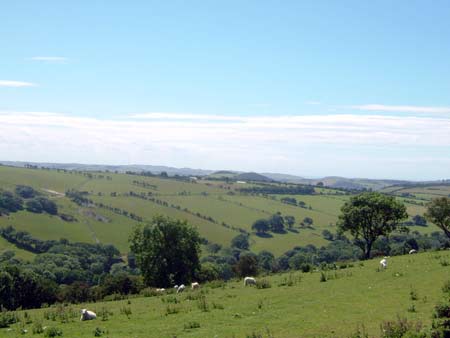
The western end of a rounded, east - west aligned ridge, ranging in height from 100m on its flanks to 180m at its eastern end. The ridge continues to climb to the east. The whole is given over to improved pasture, and is under a regular field system of small- to medium-sized fields. Field boundaries are of earth banks topped with hedges. Roadside hedges are in good condition and well maintained, elsewhere they are in fair condition, but beginning to become overgrown.
Settlement consists of a linear development at Cefn Llwyd. Older houses here are dispersed along one side of a lane and comprise small, stone built (mainly cement rendered) one, one-and-a-half and two storey late 19th century cottages. Most have strong vernacular traits, although several have been modernised and extended. Generally they do not have outbuildings, indicating a non-agricultural origin for them. They may be squatter settlements. Late 20th and early 21st century houses and bungalows have filled any gaps between older houses.
The only recorded archaeology in this area comprises a metal mine and associated leat.
This area is not particularly well defined. To the east higher formerly unenclosed land merges with this area. To the south and north lower lying and probably more ancient enclosed land forms no clear boundary with this area.
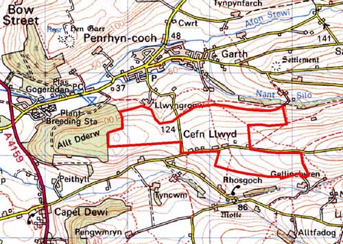
Base map reproduced from the OS map with the permission
of Ordnance Survey on behalf of The Controller of Her Majesty's Stationery
Office, © Crown Copyright 2001.
All rights reserved. Unauthorised reproduction infringes Crown Copyright
and may lead to prosecution or civil proceedings. Licence Number: GD272221