Home > Historic Landscape Characterisation > Upland Ceredigion > |

 YSBYTY CYNFYN
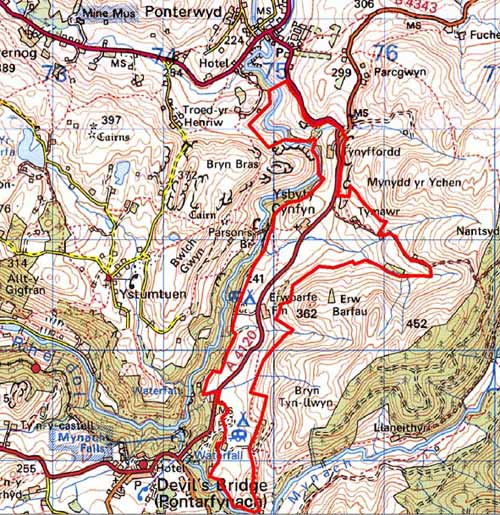
GRID REFERENCE: SN 749784
AREA IN HECTARES: 185.4
Historic Background
The early history of this area is unclear. Unlike much of the surrounding land it was not part of one of Strata Florida Abbey’s granges. The pattern of dispersed farms is probably of at least Medieval date. The majority of the area came into the possession of the Nanteos estate, and early 19th century estate maps (NLW Vol 45, 24-28) present the landscape much as it is today, with dispersed farms, small, irregular enclosures and larger enclosures on higher ground. There has been some retreat of settlement, with a farm to the east of Ty Mawr now gone, and at Erwbarfe scattered and intermixed holdings are shown; perhaps indicating the presence of a former sub-divided field system out of which the modern landscape evolved. The small church at Ysbyty Cynfyn was a chapel-of-ease and may have been a possession of the Knights Hospitaller, or may have been associated with Strata Florida Abbey. The church was rebuilt in 1827 on the site of the Medieval building (Ludlow 1998). The site of the church is of interest; several standing stones built into the churchyard wall may be of prehistoric date, though Briggs (1979) has challenged this suggestion. A visit to the church and the Parson’s Bridge waterfalls to the east in a neighbouring area was an essential item on the itinerary of late 18th and 19th century tourists to north Ceredigion.
Description and essential historic landscape components
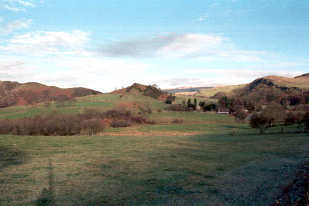
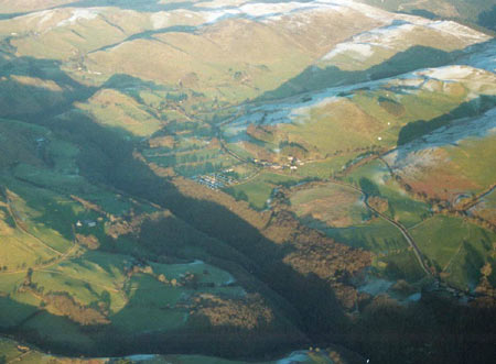
This area lies on a terrace on the east bank of the Afon Rheidol at 220m - 300m. Although mostly composed of smooth ground, it contains a craggy hill close to Ysbyty Cynfyn Church. To the west the land falls away sharply into the Rheidol valley, and to the east the land rises steeply. Improved pasture is dominant, though pockets of rougher ground are present in hollows. The field pattern is one of small, irregular enclosures, and these are divided by earth banks topped with hedges. Apart from those running along roads, which are in good condition, most hedges are overgrown and some are becoming derelict, and all are augmented by wire. Close to the church field boundaries consist of dry-stone walls. These walls are in fair condition. There are small stands of broadleaf woodland. This area lies on a major north-south route-way, now the B4343. Though no doubt an ancient road, it was converted to a turnpike in 1770 (Lewis 1955, 43-45).
The settlement pattern is of dispersed farmsteads. Traditional buildings are of stone with slate roofs. Older farmhouses are mid-to-late 19th century in date and are in the typical regional Georgian vernacular style, with gable end chimneys, a central front door, and two windows either side of the door and one above. At least one house has late 19th century gothic traits. However, many houses have recently been extensively modernised and extended or replaced. Stone farm outbuildings consist of two to three small ranges and working farms have small modern agricultural buildings. Ysbyty Cynfyn church and a small caravan park are located in this area.
The recorded archaeology of the area mostly consists of post-Medieval settlements. The presence of several deserted sites indicates a more densely populated landscape in the historic past. Metal mining remains are also evident. Bronze Age finds and a Bronze Age standing stone at Ysbyty Cynfyn Church provide time-depth to the landscape.
This area is well defined to the west and south, where it borders both woodland on the steep valley side of the Rheidol and unenclosed high ground, and to the east where it meets unenclosed land or large enclosures rising steeply to high moorland. To the north definition is less clear where this area merges with enclosed land around Ponterwyd.
Base map reproduced from the OS map with the permission
of Ordnance Survey on behalf of The Controller of Her Majesty's Stationery
Office, © Crown Copyright 2001.
All rights reserved. Unauthorised reproduction infringes Crown Copyright
and may lead to prosecution or civil proceedings. Licence Number: GD272221