Home > Historic Landscape Characterisation > Upland Ceredigion > |

 YSBYTY YSTWYTH & PONT-RHYD-Y-GROES
GRID REFERENCE: SN 741717
AREA IN HECTARES: 237.8
Historic Background
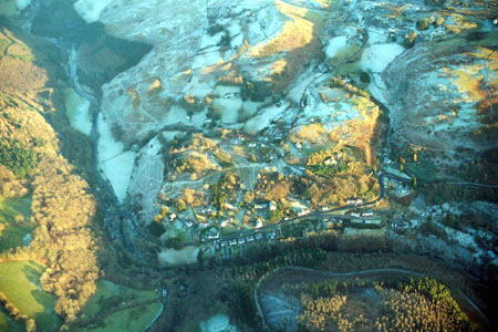
The history of this area in the Medieval Period is uncertain. The dedication of the church to St John the Baptist has been taken as an indication that is was in the possession of the Knights Hospitaller, but it is perhaps more likely that it was a hospice belonging to Strata Florida Abbey, perhaps in one of the abbey’s granges (Ludlow 1998). As this area lies on an important north - south route - from Machynlleth to Tregaron and beyond - the suggestion that a hospice was located here to tend the sick and cater for travellers and pilgrims is not unreasonable. The present church is 19th century. The later history of this area is not clear. An 18th century estate map (NLW CrosswoodVol 1, 66) shows common land within the village of Ysbyty Ystwyth, much of which had been (recently?) encroached upon by squatters who had erected cottages. It is suspected that the dense scatter of cottages across the craggy landscape to the east of the village was established by similar means and is of the same date, though there is no map evidence to support this. The later tithe map (Sputty Ystwyth Tithe Map and Apportionment, 1848) demonstrates that the settlements had been created by then. The metal mining industry in the area clearly promoted an increase in population and hence the rapid spread of dwellings across the area in the 18th and 19th century, and the development of Pont-rhyd-y-groes as a settlement. The largest and most ancient mine in the area is Logaulas, which functioned from at least the mid 18th century (Bick 1974, 22-25), but the scatter of mining remains across the landscape testifies to the extent of this once important industry. Pont-rhyd-y-groes continued to develop in the 20th century with the construction of a small housing estate.
Description and essential historic landscape components
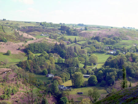
A craggy hill-crest and craggy north-facing valley side of the Ystwyth, lying to the north and east of Ysbyty Ystwyth and ranging in height from 140m to 360m. Included in this area is the small loosely nucleated village of Ysbyty Ystwyth, the straggling linear 19th century mining village of Pont-rhyd-y-groes, and numerous dispersed small cottages, houses and smallholdings. Local stone is the traditional building material; this is left bare, cement rendered or painted (whitewashed in some instances). Slate is the universal roofing material.
Ysbyty Ystwyth village is centred on the listed former parish church (now the parish room) of St John the Baptist, and the more recent church and chapels, one of which has been recently demolished. Several houses have strong vernacular traits and may date to the late 18th or early 19th century, but most are later 19th century, in the typical regional Georgian vernacular tradition and probably built for or by workers in the lead mining industry. However, farmsteads with stone-built outbuildings within and on the outskirts of the village demonstrate the agricultural origins of the settlement. There is a small estate of late 20th century houses in the village. Pont-rhyd-y-groes has a much more industrial character than Ysbyty Ystwyth. Listed buildings include a forming mining school, a mining count house and the former post office, all of mid 19th century date. Houses are mid-to-late 19th century in the regional Georgian vernacular tradition – typical worker houses for the period – although some earlier strongly vernacular cottages are also present. There is some mid-to-late 20th century housing here also. A fairly dense scatter of dispersed settlement lies on the higher, steep and rocky ground above the two villages. This is probably a squatter settlement, where people working in lead mines needed to find somewhere convenient to live. Here the houses and cottages are typically small two storey structures dating to the mid-to-late 19th century. Most are in the regional Georgian vernacular tradition, often with strong vernacular traits, but some (probably built towards the end of the century) lean more towards the Georgian style. Many have been modernised and extended. There are a few smallholdings in this area. Stone outbuildings of these are small and often attached in-line to the house. Modern agricultural buildings, where present on farms, are very small.
The area of the dispersed settlement lies on steep rocky
slopes covered with small fields, unenclosed land and woodland, intermixed
with which are the remains of lead mines. Garden trees of the houses and
cottages provide a strong woodland, almost parkland, aspect to parts of
the landscape. Fields are small and irregular, and formed by earth banks,
stone-faced banks or dry-stone walls. Hedges are not present and these
boundaries are supplemented with wire fences. Many of the small enclosures
contain improved grazing. Surrounding the enclosures is rough grazing
and moorland with peaty deposits in hollows. There are stands of deciduous
woodland and conifer plantations on the lower slopes. Buildings and spoil
heaps are the most obvious feature of the old lead mines dispersed amongst
the rocky outcrops, though shafts and other features are present.
Apart from Ysbyty Church and chapel, the recorded archaeology of this
area consists of abandoned dwellings and the remains of the metal mining
industry.
The borders of this landscape are well defined with conifer
plantations to the northwest, a landscape of large fields and rough grazing
to the northeast, east and southeast, and small enclosures to the south
and southwest.
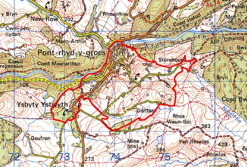
Base map reproduced from the OS map with the permission
of Ordnance Survey on behalf of The Controller of Her Majesty's Stationery
Office, © Crown Copyright 2001.
All rights reserved. Unauthorised reproduction infringes Crown Copyright
and may lead to prosecution or civil proceedings. Licence Number: GD272221