Home > Historic Landscape Characterisation > Upland Ceredigion > |

 YSTRAD FFLUR
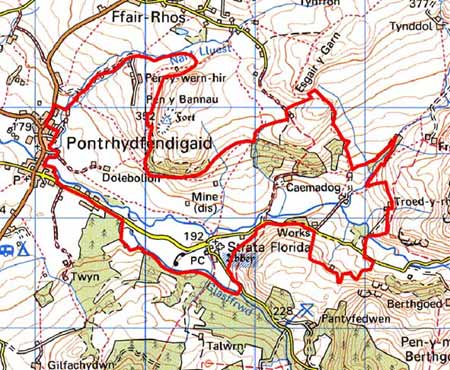
GRID REFERENCE: SN 746664
AREA IN HECTARES: 334.8
Historic Background
Strata Florida Abbey, which is located in this area, was founded in 1164. The foundation is attributed to Robert Fitz Stephen, but Lord Rhys ap Gruffydd took over the foundation, and it is to him that the first building in 1184 is attributed (Radford; Cadw 1992). The Abbey became a centre of Welsh culture and influence, and attracted many land grants, which later formed the abbey granges. Land within this landscape area lay within Pennardd Grange and Mefynydd Grange, perhaps as part of the abbey demesne. It is likely that by the end of the Medieval Period, if not earlier, abbey granges and demesne were divided into farms that were leased out on a commercial basis. This may have been the origin of the settlement pattern we see today. The granges were granted to the Earl of Essex on the Dissolution, who subsequently sold them to the Crosswood estate in 1630. John Stedman acquired Abbey demesne in 1567. He built Abbey Farm mansion adjacent to the abbey. The present house dates mainly to the late 17th century, and has largely remained unchanged since the 1740s (Smith 1998, 270). However, Richard Stedman died intestate in 1746 and the estate passed to the Powells of Nanteos. Nanteos had considerable holdings here in the 19th century. A church to serve the local community was constructed on the north side of the abbey ruins in the 17th century. The later history of the area is unresearched, however, historic maps including tithe maps (Caron Tithe Map and Apportionment, 1845; Gwnnws Tithe Map and Apportionment, 1847) and late 18th century estate maps (NLW Crosswood Vol 1, 66; NLW 45; 59, 62, 63, 71, 72), demonstrate that this area had achieved much of its present character (field systems, settlement pattern, lead mines) by then. Abbey Consols metal mine was most active in the mid to late 19th century.
Description and essential historic landscape components
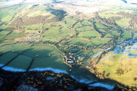
This area consists of the valley floor of the Teifi to the east of Pontrhydfendigiad and the lower slopes of the valley side. It ranges in height from 180m on the valley floor to almost 300m at its northern end, where it climbs the valley side to include Pen-y-wern hir Farm. It is a landscape of small, irregular enclosures and scattered farms. Boundaries to the enclosures consist of earth banks with occasional stone-faced banks. Hedges on top of these banks are in fair to good condition, though away from the valley floor they are becoming derelict. Most hedges are supplemented with wire fences. Occasionally a hedge supports distinctive hedgerow trees. Strata Florida Abbey has a concentration of dry-stone wall boundaries around it. There are some small stands of deciduous woodland. Improved grazing is the dominant land-use, with some pockets of rougher grazing on the valley floor.
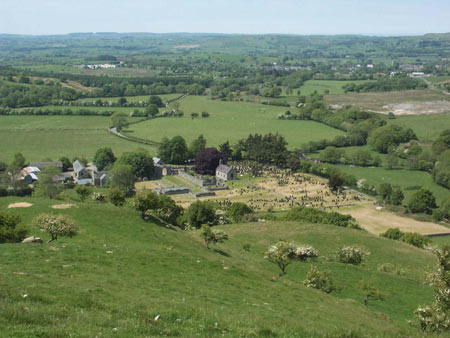
The ruins of Strata Florida Abbey, the post-Medieval Church and Great Abbey Farm house and associated outbuildings provide a dramatic focus to this landscape. They are all built of local stone, which was the traditional building material of the region until the early 20th century. On domestic buildings stone is left bare, cement rendered or painted, and is always left bare on farm outbuildings. Apart from the 18th century gentry house of Great Abbey Farm, one of the largest farmhouses in upland Ceredigion, houses date to the mid-to-late 19th century and are in the typical regional Georgian vernacular style, with gable end chimneys, a central front door, and two windows either side of the door and one above. Great Abbey Farm has very substantial ranges – barn, cow house, stables, cart houses, etc – arranged formally around a yard as befits a house of its status, but most farms have two or three ranges of smaller outbuildings arranged informally with the house. Working farms have substantial modern agricultural structures. A few modern houses and a water treatment works lie in this area. The stone buildings and spoil heaps of old lead mines provide a distinctive landscape component to this area.
The recorded archaeology of this area is clearly focused on the abbey and its immediate environs. Greater time depth to the landscape is provided by a Roman coin hoard, a Dark Age inscribed stone, and reference to a Medieval mill site.
To the north unenclosed land and large enclosures provide
a sharp border to this landscape area. There is a less clear border with
enclosed land to the south; rather there is a zone of change between the
two areas. To the west lies the village of Pontrhydfendigaid.
Base map reproduced from the OS map with the permission
of Ordnance Survey on behalf of The Controller of Her Majesty's Stationery
Office, © Crown Copyright 2001.
All rights reserved. Unauthorised reproduction infringes Crown Copyright
and may lead to prosecution or civil proceedings. Licence Number: GD272221