
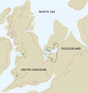
Map of Doggerland in the North Sea (after Bryony Coles) |
|||||||||
 |
|
||||||||
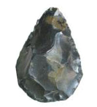 |
A small Paleolithic flint hand axe
- one of many prehistoric artefacts discovered during dredging in the Doggerland area |
The sandbank called Dogger Bank lies within the North Sea, some 100km from the modern coast of Britain. It comprises a submarine plateau covering approximately 17,600km² that rises about 45m above the seabed. Peat deposits and the bones of animals including mammoth, woolly rhinoceros and hyena from differing pre-historic periods have been regularly trawled from this surface from the 19th century right up to the present day. It was Clement Reid who first postulated that this wealth of tangible evidence from Dogger Bank was part of a much bigger picture, forming the northern edge of a huge plain that once covered the whole of the southern North Sea. For most of the 20th century this inundated area was referred to as a ‘land-bridge’ between mainland Europe and Britain, a means to an end rather than of any real intrinsic value in itself. This is perhaps understandable considering its inaccessibility and it was not until 1998 that a synthesis of the available data by Professor Bryony Coles, at the University of Exeter, helped to reignite archaeological interest in the North Sea. She named this prehistoric landscape that once reached, without a break, from England to Denmark after the bank first identified by Reid – ‘Doggerland’ and it was this submerged environment that The University of Birmingham studied in 2007, in its pioneering project to use existing seismic data collected by commercial companies to map the ancient landscape of the sea bed. Following the success of this project a partnership was formed with Dyfed Archaeological Trust and the RCAHMW to gather evidence for submerged landscapes in the study areas of the Liverpool Bay and the Bristol Channel as illustrated in the map. |