
 |
In the footsteps of our ancestors.
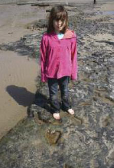
Lydstep Beach, Pembrokeshire, 2010. Eight-year old Catrin Murphy stands near the preserved
footprints created by a similar aged child some 6000 years ago. |
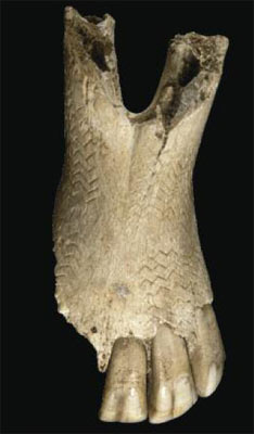 |
A decorated horse jaw from Kendrick’s
Cave, Llandudno, Conwy, dated to the later Palaeolithic, about 13,500 years old. The carefully
incised blocks of zig-zag decoration that cover the underside of the jaw were drawn with
a flint tool. This is the earliest example of decorative art in Wales and also an exceptional
find of Ice Age art rarely found across the whole of Europe. It was found in association
with a rare group of nine decorated cattle and red deer teeth and the human bones of three
adults and one child. |
This website is the result of a partnership between Dyfed Archaeological Trust, the Royal Commission on the Ancient and Historical Monuments of Wales (RCAHMW) and The University of Birmingham, whose aim was to summarise recent research into the prehistoric landscapes beneath the Bristol Channel and Liverpool Bay. The University of Birmingham used the data collated through seismic reflection surveys, carried out by commercial companies searching for gas and oil reserves or planning mineral extraction, to identify and record the submerged landscapes that survive below these areas. These seismic surveys can detect earlier coastlines, higher ground, river valleys and flood plains, and in so doing provide valuable information about potential locations of archaeological sites. The information was gathered within a computer mapping system and interpreted to produce maps showing broad landscape changes. These will be used to help with the future management of the survey areas and protect them from the potential impact of dredging or offshore development. After the last great Ice Age, global warming raised sea levels to such an extent that vast areas of lower lying land between Britain, Ireland and Continental Europe became flooded and the British Isles, as we now know them, were eventually created. For thousands of years these now lost lands formed the living landscape of our ancestors. Indeed, these areas were the heartland for Mesolithic communities, providing fertile land with rich, diverse resources, until flooding forced them back onto the higher lands we live on today. This study of the Bristol Channel and Liverpool Bay follows on from The University of Birmingham’s pioneering work in 2007 on the submerged landscapes of the southern North Sea, now referred to as ‘Doggerland’. This revealed a submerged Mesolithic landscape in unprecedented detail, significantly changing the way that prehistory is perceived and understood by archaeologists. Already, in recent work on data from the North Sea, there is an indication that some areas may have remained habitable much longer than initially thought, perhaps even into the early Neolithic period.
|