|

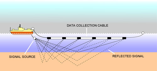
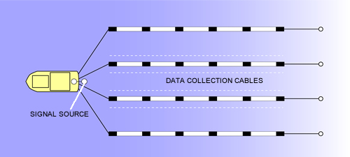
How the data is obtained The vast submarine landscapes of the Bristol Channel and Liverpool Bay cover many hundreds of square kilometres. The only technology able to penetrate the overlying silts and provide information at a landscape scale is seismic reflection survey. This involves sending soundwaves into the subsurface and then recording the echoes that are reflected back, depending on changes in the sediments below. The time taken to record a reflection can be converted into an approximate depth. This information, recorded as a continuous trace, can be illustrated as a cross section through the seabed. Such information has many commercial uses. Energy companies explore the seabed for oil and gas reserves. Aggregate companies use the data to locate sands and gravels suitable for extraction. Engineers use shallow seismic surveys when laying pipes, constructing drilling rigs or building wind farms, to better understand the nature of the sea bed. The data is collected in either two-dimensional (2D) or three-dimensional (3D) surveys. 2D data is collected through a single cable and displays a vertical slice through the seabed. 3D surveys utilise multiple, closely spaced cables to provide data that can be viewed in section or in plan. Archaeologically 3D data is most useful for exploring large submerged landscapes but used alongside 2D data a better picture of the submerged landscape can be constructed. |
|