
CILGERRAN
Click here for a copy of the full report
SUMMARY
In 1292 just 22 taxpayers are recorded in the small settlement that had developed organically from the early twelfth century outside Cilgerran Castle. However, in the late thirteenth/early fourteenth century a more formal settlement was created – burgage plots were laid out flanking a long, triangular marketplace. This formalisation probably coincided with the granting of a weekly market and two annual fairs. No town charter is known. The later medieval and early modern history of the town is entirely unknown. Apart from a small-scale watching brief there have been no archaeological investigations in Cilgerran.
KEY FACTS
Status: Weekly market and two annual fairs.
Size: 1292 22 taxpayers.
Archaeology: No significant archaeological interventions.
LOCATION
Cilgerran in Pembrokeshire lies on the south side of the River Teifi gorge (SN 195 430). The river is tidal to Cilgerran. The town and port of Cardigan lies 3km downstream and Newcastle Emlyn 10km upstream. Main roads now bypass the town, but formerly it would have lain on the main east-west route along the Teifi valley and on a north/south route linking Cardigan to the north and south Pembrokeshire to the south.
HISTORY
The dedication of the parish church to St Llawddog and the presence of an early medieval monument in the churchyard is strong evidence for a pre-Anglo-Norman religious foundation at Cilgerran. The present church, lying to the west of the village and castle, has medieval elements but was largely rebuilt in the mid-nineteenth century.
In 1108, during the Anglo-Norman invasion of southwest Wales, Gerald of Windsor built a castle at ‘Cenarth Bychan’, probably what we now know as Cilgerran. In common with other castles in the region control of Cilgerran Castle alternated between English and Welsh rulers during the twelfth and thirteenth centuries. The extant masonry castle dates mainly to the thirteenth and fourteenth centuries.
During the twelfth century a settlement developed outside the castle gates. This is referred to as a town in 1204. A weekly market and two annual fairs were held, and the town was governed by a portreeve, aldermen and burgesses. It was a town by prescription as no town charter is known. Despite being on a tidal river, there is no evidence it ever functioned as a port. In 1292 just 22 taxpayers are recorded. The later medieval and early modern history of Cilgerran is unknown, but development must have been impeded by the growing importance of Cardigan just 3km downstream. Although John Speed lists it as one of the principal market towns in Pembrokeshire in the early seventeenth century, Cilgerran’s main function was to serve a large agricultural hinterland. However, in addition to the largely agricultural produce traded at the weekly market and annual fairs fishing and quarrying would have provided additional income for the town’s people. In the thirteenth century there were complaints that boats carrying timber and stone to Cardigan Castle were impeded by Cilgerran’s fisheries and it was ordered that they should be removed. They were rebuilt in 1314. In about 1600 George Owen described the fish trap on the Teifi as the ‘chiefest weir of all Wales’. Burgesses had the right to quarry stone in the Teifi gorge.
MORPHOLOGY
Cilgerran occupies fairly level ground at about 40m above sea level on the south side of the Teifi gorge. The River Teifi is tidal up to Cilgerran. The castle sits on a promontory formed by the gorge to the north and east and the steep valley of the Afon Pysgog to the west.

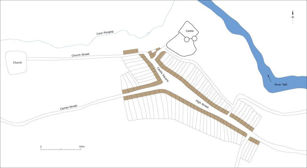
Map showing Cilgerran as it may have been at its maximum extent in the medieval period, c.1320.
The town consists of one main street, High Street, which bifurcates to the south of the castle becoming Castle Square and Cemes Street. Close to the castle and on the north end of Castle Square development seems to have occurred organically, with house plots showing no coherent plan being different sizes and shapes; this is the small settlement that grew organically outside the castle in the twelfth century. This haphazard development contrasts sharply with the regular, long, narrow house plots flanking High Street, Cemes Steet and the south end of Castle Square; these are burgages almost certainly planned and laid out as a unit and centred on a long triangular marketplace at the junction of the three streets. There is no evidence indicating that the settlement was ever defended. The 1844 tithe map shows 60-70 regular house plots, but many of these at c.7m wide are narrower than a traditional burgage plot and are evidence of sub-division having taken place, either during a period of population growth in the medieval period, or more probably more recently. It is uncertain when the marketplace and burgage plots were laid out, but as the 22 taxpayers recorded in 1292 could have been easily accommodated in the houses outside the castle it is most likely to have been in the late thirteenth/early fourteenth century, probably at the same time that Cilgerran was granted its weekly market and annual fairs.
Some writers have interpreted house plots further west along Cemes Street, further east along High Street and along Church Street as later medieval expansion. There may have been limited expansion in these areas in the medieval period, but Thomas Budgen’s map of 1810 in the British Library and the 1844 tithe map show these areas largely devoid of buildings and therefore development can be assigned to the later nineteenth century and twentieth century, probably associated with the rapidly expanding quarrying industry.
Most nineteenth century development, however, occurred to the east of the historic core of the town and in the Pysgog valley. It is only in the second half of the twentieth century and later that a significant number of new houses were built on the fringes of the town.
