
NEWPORT
Click here for a copy of the full report
SUMMARY
William Fitzmartin founded Newport in the late twelfth century, laying out a grid pattern of streets; a pattern that is still evident. During the thirteenth century the focus of the town moved from the northern end to the southern end close to the church and castle, resulting in the desertion of that part of the town close to the estuary. Archaeological excavation in the deserted northern part of the town revealed a pattern of burgages and dwellings associated with the town’s foundation. Overall the town seems to have undergone depopulation from the thirteenth century; evaluation excavation on undeveloped land in the southern part of the town identified and to some extent characterised this depopulation. Well-preserved late medieval pottery kilns discovered in 1921 demonstrate that important archaeological remains may be found in just about any location in the town.
KEY FACTS
Status: 1241 town charter.
Size: 1434, 233 burgages in the hands of 76 burgesses.
Archaeology: Excavations have demonstrated that deposits dating to the medieval period survive in the town.
LOCATION
Newport lies on a gentle north-facing coastal plain on the south side of the Nevern estuary in north Pembrokeshire (SN 058 393), 1.2 km from the sea. To the south of the town the land rises steeply to the rocky summit of Carningli at 346m. The A487 coastal trunk road runs east-west through the town.
HISTORY
William Fitzmartin founded Newport c.1197. The Fitzmartins had taken control of north Pembrokeshire in the early twelfth century, establishing a castle at Nevern, a few kilometres upstream of Newport. Nevern Castle changed hands several times during the twelfth century, with the Welsh under Rhys ap Gruffudd in the ascendancy for much of the latter part of the century. When the Fitzmartin’s regained control towards the end of the century, they abandoned Nevern in favour of establishing a new town and castle at Newport. The privileges granted by William Fitzmartin to the town in 1197 were confirmed in a charter by his son, Nicholas, in c.1241. The thirteenth century was as tempestuous as the previous century; in 1215 Llywelyn ap Iorwerth destroyed Newport Castle and in 1257 it was again razed to the ground, this time by Llywelyn ap Gruffudd.

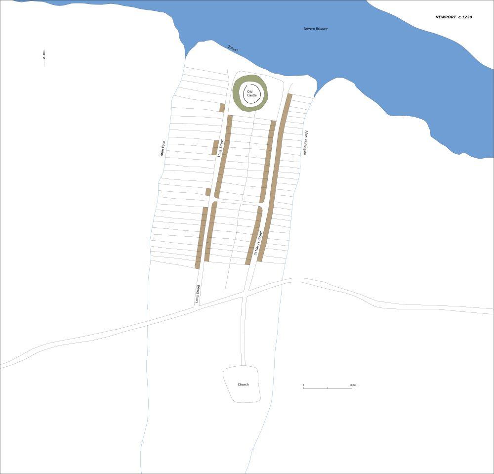
Newport as it may have been c.1220.
William Fitzmartin’s original castle was probably the ringwork, now known as Old Castle, on the shore of the estuary. Two long streets, Long Street and St Mary’s Street, were laid out running south from this castle. It is likely that the castle was relocated to its present commanding position at the south end of the town following the attack of 1215 or that of 1257. The focus of the town moved from the estuary and Old Castle to the south, close to the new castle with a grid pattern of streets being laid out. All the appurtenances of a medieval borough – the church, market cross and shire hall – were situated in the southern part of the town.
A survey of 1434 records 233 burgage plots in the hands of 76 burgesses. The survey records that by 1434 the town had expanded with plots having been laid out along West Street, East Street and Bridge Street. However, with just 76 burgess recorded it is likely that some of the burgages had fallen vacant. Certainly, an archaeological excavation on Long Street in 1991 confirmed that plots in the northern part of the town had been abandoned early in the thirteenth century and never reoccupied.
A rental of 1594 records further depopulation, with just 44 of 211 burgage plots occupied, all clustered in the southern part of the town. Consolidation of plots into small fields had taken place in the northern part of the town close to Old Castle. Clearly the town was in an advanced state of decay and did not start to recover until the late eighteenth century when Richard Fenton noted: ‘the chasms in its depopulated streets are filling up fast with buildings’.
The Parrog to the west of the town, close to the mouth of the estuary, is a small quay and had been since at least the eighteenth century; its earlier status is uncertain. It is likely that the original ‘port’ of Newport was by Old Castle, but as the estuary silted it shifted to the Parrog; this could have occurred in the medieval period.
MORPHOLOGY
Newport has the classic traits of a planted, planned medieval borough, much of which is readable on modern maps and in the town’s morphology. Long Street and St Mary’s Street run parallel from the estuary to the south for 550m, bounded on the west by the stream Afon Felin and to the east by Afon Ysgolheigion. The streets and the streams package what is probably the first phase of the town into a neat rectangle. Long narrow burgages lie on both sides of these streets: at the southern end late eighteenth/nineteenth century stone-built houses and commercial premises occupy the plots, with a few later buildings; at the northern end the plots are vacant or have been amalgamated into small fields. A late twentieth century primary school occupies several plots towards the northern end of Long Street.

Newport as it may have been c.1320.
A second phase of the town is represented by the grid pattern of streets at the southern end of the town. West Street, East Street, Goat Street and Bridge Street are probably the result of further phases of expansion. Results of an archaeological evaluation in 2011 indicate that burgages on Goat Street were laid out in the late fourteenth/early fifteenth century. Most of the burgages in the southern portion of the town are occupied by eighteenth/nineteenth century stone-built houses with some later buildings. There are few vacant plots.
There is no evidence in the morphology that the town was provided with defences. However, the excavator of a 2011 evaluation suggests that a double ditch pre-dating burgages on Goat Street could have functioned as a defensive feature associated with an early phase of the town.
Newport Castle, a substantial earthwork with masonry dating mainly to the fourteenth century, stands on a high point at the south end of the town. A mid-nineteenth century house, still occupied, was built into the gatehouse.
St Mary’s Church is assumed to have been founded at the same time as the town. The present building is largely medieval; it was restored several times during the nineteenth century. It stands in a churchyard in the south part of town below the castle.
There are some modern houses on single plots in the core of the town, but recent housing is largely confined to the fringes of the town outside the medieval core recorded in the 1434 survey.
Former sub-division of fields on the west side of Long Street, northern end, is visible on LiDAR imagery. These are former burgages recorded in 1434. No such sub-divisions are visible on the east side of Long Street or the east side of St Mary’s Street, northern ends. A sports field occupies the east side of Long Street – it is likely that landscaping of this has taken place. Agriculture over several centuries has probably erased the superficial evidence for burgages on the east side of St Mary’s street.
Newport as it may have been c.1320.
