|

280 EGLWYSWRW 
GRID REFERENCE: SN124368
AREA IN HECTARES: 3053
Historic Background
A large area of modern Pembrokeshire to the north of Mynydd Preseli,
within the medieval Cantref Cemaes, Uwch Clydach commote. Cemaes was brought
under Anglo-Norman control in c.1100 by the Fitzmartins who retained it,
as the Barony of Cemaes, until 1326, when they were succeeded by the Audleys.
The Barony was conterminous with the later Hundred of Cemais, which was
created in 1536, but many feudal rights and obligations persisted, some
until as late as 1922. This character area lies within Nevern, Meline,
Eglwyswrw, Eglwyswen (Whitchurch) and Llanfair Nant Gwyn parishes. Nevern
parish was a borough of the barony, while Meline and Eglwyswen - within
which Llanfair Nant Gwyn formerly lay - were held immediately of the Lords
of Cemaes. Eglwyswrw was held, from the 13th century onwards, as a demesne
manor or sublordship of the Lordship of Cemaes, with its own manorial
court. It contains three early earthwork castles. In the 16th century,
the militias of both Cemais and Cilgerran mustered on the site of a building
in the village, still known as the 'Armoury'. However, the settlement
appears to have earlier origins. The church may be on a pre-Conquest site,
while a study of deserted rural settlement sites by Sambrook has identified
seven potential settlement foci within the sublordship of Eglwyswrw, that,
perhaps correspond to Jones' model of an early 'multiple estate'. Welsh
systems of tenure appear to have persisted throughout the area, with the
subsequent development of a number of small landholdings. Each of these
was associated with a gentry house of varying status, but by the 16th
century the landholdings had mainly become amalgamated under the Owen
family of Henllys. Among the most important was Glanduad which may have
been inhabited since the early 14th-century. Hendre is mentioned in a
deed of 1407, while a messuage, 14 acres, a mill and a meadow at Clyn
Meredith are recorded in 1418. The original buildings at Penybenglog were
in ruins by the early 17th-century when the owner enlarged the demesne,
while Argoed is described by George Owen of Henllys as similarly 'a house
of long continuance' in 1603, when Henllan Owen is also described as a
'mansion house'. Evidence for the houses of the rural poor is provided
by a description of the village of Felindre Farchog as composed of earth-built
cottages. There is some common land, but it is associated with village
rights, as at Eglwysrwrw, rather than relict. It is apparent that the
entire area was settled, and probably enclosed with the present system
of regular fields, by the early post-medieval period. The character area
has been crossed by the main Haverfordwest-Cardigan route since the medieval
period, which was later turnpiked and is now the B4329. A coaching inn
- the Serjeants Arms - has stood in Eglwyswrw since the mid 18th-century.
Here, during the 19th and 20th centuries, the Cemaes Petty Sessions were
held. The Fishguard-Cardigan route (A487) is of similar age to the B4329
and was a factor in the development of Felindre Farchog, which boasted
both a woollen mill and a tannery, and was largely rebuilt in the 'estate'
style in the 19th century. Although industry was never a major factor
in the development of this landscape, there was some small-scale lime
production while the area was one of the main centres of woollen production
in Pembrokeshire, with at least 6 recognisable 16th century fulling mill
sites, and several factories that continued production into the 20th century
including Pontyglasier. However, they appear to have had little effect
on the settlement pattern which remained chiefly dispersed.
Base map reproduced from the OS map with the permission
of Ordnance Survey on behalf of The Controller of Her Majesty's Stationery
Office, © Crown Copyright 2001.
All rights reserved. Unauthorised reproduction infringes Crown Copyright
and may lead to prosecution or civil proceedings. Licence Number: GD272221
Description and essential historic landscape components
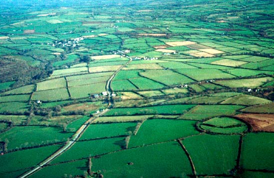
Eglwyswrw historic landscape character area consists of rolling hilly
ground lying approximately between 20m and 180m on the northern side of
Mynydd Preseli. There is an increase in height across the area from west
to east, the western end being just a few kilometres from Newport Bay.
Apart from on steep-sided valleys and on the small common at Eglwyswrw,
all the land is divided into medium-sized fields. These vary in shape
from the irregular through to the strongly rectilinear such as those that
exist south of Penygroes Chapel. These differences presumably represent
different periods of enclosure, or enclosure by individuals as opposed
to estates, but in no-way do they prejudice the integrity of the area.
Boundary banks are made of earth or stone and earth, with a few stone-faced
banks also present. Most banks are topped with hedges. Hedges are generally
well maintained, but in certain locations they are becoming neglected
and overgrown. Deciduous woodland lies on some of the steeper valley sides
and in small copses irregularly scattered across the area. Trees in the
hedgerows also add to the wooded aspect of parts of this area. However,
woodland is not as prominent as in some neighbouring areas, and is not
a defining characteristic of the historic landscape. Agricultural land-use
is predominantly pasture, most of which is improved, with small pockets
of rougher rushy ground. About 10% of the land is under arable cultivation.
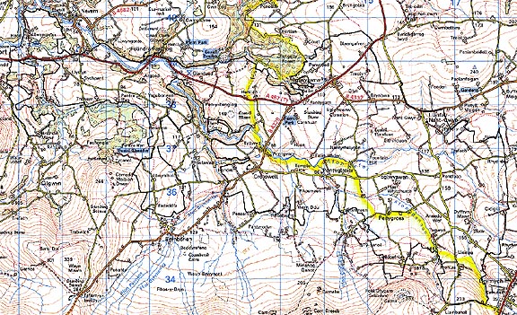
Apart from the two villages of Eglwyswrw and Felindre Farchog and the
lesser hamlets of Ffynnongroes and Pontyglasier, the settlement pattern
is of dispersed farms, houses and cottages. Dwellings are of a variety
of styles and dates, but the main type is 19th century, stone-built (cement
rendered and bare stone), slate roofed, two storey and three bays, with
examples in both the vernacular and more polite Georgian tradition. Other
19th century dwellings include stone-built one and one-and-a-half storey
cottages and houses in the vernacular tradition, substantial stone-built
houses possibly of 18th century date, and a whole range of 20th century
dwellings from brick houses through to concrete-built bungalows. There
are 38 listed buildings within the character area, four of which are rebuilt
medieval churches. Seven, including the 'Armoury' and the Serjeants Inn,
are in Eglwyswrw village, and are Grade II listed except the church which
is Grade - listed. Eight listed buildings (also Grade II) are in Felindre
Farchog. The remainder are located in the holdings of Llwyngwair (five
listed buildings), Pentre Ifan (three listed buildings) and Trewern (four
listed buildings). Other houses include Glanduad, 'a typical old Welsh
gentry house with a simne fawr' (stone chimney), and the 18th century
Penybenglog House. There are chapels at Penygroes and Pontyglasier. Pont
Gynon bridge was mentioned by George Owen in c.1600. Older farm out-buildings
consist of one or two ranges of stone-built structures, and, on occasions
brick-built structures. These older buildings are often in a semi-formal
arrangement with the house. More recent agricultural buildings include
20th century corrugated-iron barns and other buildings, and late 20th
century steel, concrete and asbestos structures. On the larger farms the
latter type can be substantial. Eglwyswrw, the chief village of the area,
has developed around the medieval church site, and comprises, as well
as dwellings, a school and public houses. Felindre Farchog is centred
around a chapel, as is Pontyglasier. Other religious buildings such as
the churches at Meline and Llanfair Nant Gwyn and the chapel at Penygroes
have not attracted settlements. The main transport element of the landscape
is the A487(T) which runs from west to east through the area and on which
the villages of Felindre Farchog and Eglywswrw are situated. Minor roads
- the B4332 and the B4329 - branch from this A-road. Lanes and tracks
are narrow and winding and for local-use only. All roads, lanes and tracks
are bounded by boundary banks.
Recorded archaeology in such a large area is rich and diverse. Prehistoric sites comprise two neolithic findspots, a neolithic or bronze age megalithic structure, three bronze age findspots, one definite and three possible bronze age standing stones and two possible round barrows, a large, scheduled iron age hillfort and four possible hillforts, one of which may be a medieval motte. There is a possible dark age llys site. From the medieval period are three scheduled earthwork castles, including Eglwyswrw, the four medieval churches, two medieval chapel sites, a number of holy wells and a possible cemetery site. There are several medieval and post-medieval mill sites. Pont Baldwyn on the A487 may be medieval, and Pont Clydach bridge was also mentioned by George Owen in c.1600. Other post-medieval sites are represented by quarries, a limekiln and a world war two pillbox.
This area is well defined to the south and southwest where it borders areas consisting of smaller farms and more irregular field systems. To the north and east historic landscape character areas have yet to be defined, but generally here the landscape is composed of larger, more regular enclosures and larger farms, and has a more open aspect.
Sources: Charles 1948; Charles 1992; Eglwyswrw tithe map and apportionment, 1841; Howells 1977; Jones 1996; Lewis 1972; Llanfair Nant Gwyn tithe map and apportionment, 1838; Ludlow 1998b, Meline tithe map and apportionment, 1841; Nevern tithe map and apportionment, 1843; Pembrokeshire Record Office HDX/760/3; Rees 1932; Sambrook 1997; Sambrook 2000; Whitchurch tithe map and apportionment, 1841