Home > Historic Landscape Characterisation > Carmarthen Bay Estuary Area > |

 SIR JOHN'S HILL
GRID REFERENCE: SN 304098
AREA IN HECTARES: 22.22
Historic Background
Although this area lies within the demesne of the Lordship of Laugharne, held under manorial tenure, its economic value has probably always been low due to the fact that most of it is represented by cliffs. Historic maps record it as wooded, as it is today. However, there is a documented medieval settlement at Cyn Gaddael at the far western end of the area. Several abandoned stone-built cottages, as well as an abandoned building known as Salt House and the present Salt House Farm, are probably evidence for a squatter settlement of 18th- or 19th-century date. The abandoned buildings were occupied until 1947. These dwellings are either located on the steep wooded slope above the cliffs, or at the foot of the cliffs on the edge of former salt marsh. A scenic walk - New Walk - was built across this area in the 19th century. The name Sir John's Hill is reputed to refer to Sir John Perrot, Lord of Laugharne in the late 16th-century, who was notorious within the area for his acquisitiveness, and is the title and subject of a poem by Dylan Thomas.
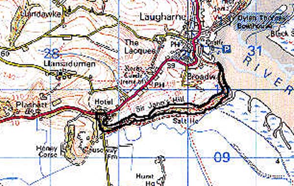
Base map reproduced from the OS map with the permission of Ordnance Survey on behalf of The Controller of Her Majesty's Stationery Office, © Crown Copyright 2001. All rights reserved. Unauthorised reproduction infringes Crown Copyright and may lead to prosecution or civil proceedings. Licence Number: GD272221
Description and essential historic landscape components
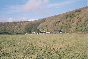
This area comprises a former Old Red Sandstone sea-cliff which rises from the saltmarsh and reclaimed marsh to over 70 metres. Nearly all the area is either vertical cliff or very steep slopes and is cloaked in ?ancient deciduous woodland. Towards the crest of this area, where the land begins to level out, one or two abandoned stone-built cottages are masked by trees. A scenic walk leads through this area from Laugharne.
Apart from the documented medieval settlement at Cyn Gaddael there is no other recorded archaeology within the area.
Apart from Salt House Farm, a late 19th-century house in the vernacular style, the only buildings are the stone-built ruins of 19th century houses and cottages in woodland.
This relict cliff line provides a clear boundary between the reclaimed marsh to the north and rolling farmland to the south, and is a very distinct historic landscape area.