Home > Historic Landscape Characterisation > Carmarthen Bay Estuary Area > |

 KIDWELLY AND LLANSAINT STRIP FIELDS

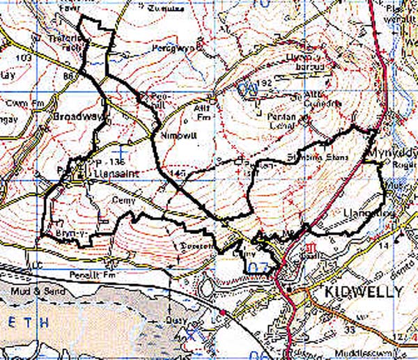
GRID REFERENCE: SN 389085
AREA IN HECTARES: 345.60
Historic Background
An area lying within both the Medieval borough limits of Kidwelly to the east, and St Ishmael to the west which was held as a foreignry of Kidwelly Lordship (Rees 1953, 175-212). It has a good documented Medieval and Post-Medieval history. The area was granted to Bishop Roger of Salisbury in 1106 (Avent 1991, 167), which heralded its reorganisation along manorial lines. It passed between Anglo-Norman and Welsh hands during the 12th- and early 13th-century, but more settled conditions prevailed in the later 13th- and 14th-century under the tenure of the Chaworths and, from 1327, the Duchy of Lancaster. Within St Ishmael foreignry to the west is the church of All Saints at Llansaint, which lies at the centre of a nucleation now generally agreed to be the site of the 'Halkyn' or 'Hawkin' shown on early maps (James 1991, 144-5; Rees 1953, 174). The nearby field names 'Park Whitland' and 'Park y Prior' may commemorate former monastic land. Part of the eastern half of this area, which lay within the borough of Kidwelly, was called 'Shilland Field' (sharelands?) during the early Post-Medieval period and was divided into common pasture above 90 m and open field strips below. A nearby area, 'Burghylle', may have belonged to Kidwelly Priory (Barnie and James, 1977, 45). Strips belonging to the lord of the manor (Coed yr Arglwydd), and a local family called Barret, are recorded in tenement names of 1609 (Rees 1953, 207); the former name suggests the presence of woodland that was felled in the Medieval period. In 1630 the lordship of Kidwelly was sold to the Carbery earls who held it until 1804 when it passed to the Cawdor estate (Jones 1983, 18); subsequent development has been small-scale.
Base map reproduced from the OS map with the permission
of Ordnance Survey on behalf of The Controller of Her Majesty's Stationery
Office, © Crown Copyright 2001.
All rights reserved. Unauthorised reproduction infringes Crown Copyright
and may lead to prosecution or civil proceedings. Licence Number: GD272221
 Description and essential historic landscape components
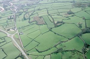
An area lying between 25 m and 150 m, of a general southerly aspect. The manorial nature of tenure within the area during the Medieval period has given rise to a landscape characterised by its relict field strip system, the former strips of which were still apparent in 1840 (Kidwelly and St Ishmael tithe maps). There is little woodland, all of it secondary. There is the usual scatter of farmsteads and cottage sites. Within the foreignry of St Ishmael to the west, a nucleation around Llansaint Church - which occupies a distinct, central location within the village - lies at the focus of a number of roads within a discrete area of former field strips. The main Kidwelly-Ferryside road follows the line of a ?Medieval routeway called the 'Ferry Way', which led from Kidwelly to the Llansteffan Ferry over the Tywi estuary (Rees 1932). A spur from this route is one of the routes that converges on Llansaint and was known as the 'Portway'. This half of the area is now all improved pasture with long, medium-sized enclosures divided by earth banks with low hedges, predominantly well-maintained. The eastern half of the area, which lay within the borough of Kidwelly, features numerous strip lynchets below 90 m, above which was common pasture (Barnie and James, 1977, 45) which may have been seasonal. The landscape here also features an overgrown hollow-way, 'The Summerway', recorded in 1396. This area would seem to have been embanked and hedged by the 16th century and there are a number of relict boundaries and boundary stones (Barnie and James, 1977, 42). However, the direction of a turnpike road through the area between 1763 and 1811, ie. the present A484 (M S C Evans 1988, 66), affected a reorganisation of some of the boundaries; the earlier route followed a similar course and its boundaries are still present. This eastern half is basically an area of improved pasture but there is some bracken on steep slopes. The long, medium-sized enclosures are divided by earth banks with hedges, some of which are becoming overgrown and derelict with distinctive trees, but are well-maintained along the roadsides. In both areas the present settlement pattern is mainly one of dispersed farms, and there has been little modern development within the nucleation of Llansaint.
Recorded archaeology, in addition to the features mentioned above, includes elements from underlying landscapes such as two (possibly three) standing stones and two possible round barrows, from the Bronze Age, and a possible Bronze Age henge or Iron Age hillfort. The Medieval All Saints Church, Llansaint, with a landmark tower, is Grade B listed. The area also features a number of natural springs and wells, some of which are mentioned in late Medieval accounts and the possible site of a chapel dedicated to St Thomas near Kidwelly (Rees, 1932). Later archaeology is mainly represented by buildings.
Farmhouses are generally 19th century, stone-built and slate-roofed, two-storey, three-bay, rendered and in the vernacular tradition. Most farms have two or more ranges of stone-built, 19th century outbuildings as well as modern agricultural buildings. Llansaint village is characterised by a cluster of 19th century stone-built houses around the church surrounded by a loose girdle of farmsteads and modern residential development. There is a former smithy in Llansaint, and two pounds.
This is a fairly distinct historic landscape area which contrasts with the pattern of more regular enclosures to the south and east and the large, very regular enclosures to the north and west.