|

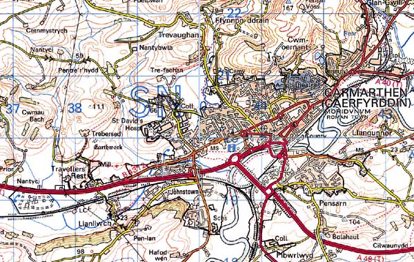
181 CARMARTHEN 
GRID REFERENCE: SN 411198
AREA IN HECTARES: 733. 10
Historic Background
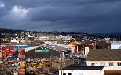
The built-up area of the town of Carmarthen, a Roman civitas capital, Medieval borough and county town in which there has been considerable survival of historic landscape features. The Roman town of Moridunum had been established by the early 2nd century as an eastern suburb of a fort from 75 AD (James 1992, 32). A Dark Age presence is represented further east by the clas church of St Teulyddog, and possibly by the parish church of St Peter which partly overlies the Roman west gate. Carmarthen's post-Conquest history (this account of which is based on James 1980, and Lodwick and Lodwick 1972) begins with the establishment of a castle in 1093, not on the present site but at Rhydygors to the south of the landscape area. This was abandoned in favour of the present castle site in 1109, which was doubtless chosen for strategic reasons overlooking a bridging point possibly used by the Romans, but far enough from the clas and St Peters Church - which together were subsequently termed 'Old Carmarthen' - to not be regarded as an interference. A royal foundation, the castle developed as the focus for a small borough - New Carmarthen - which received a charter under Henry II, and masonry defences in the 1230s. A substantial suburb developed along the route west of the town (Lammas Street) and between the walled town and St Peters Church, along King/Spilman Streets. In 1275 there were 181 burgesses but the elevation of Carmarthen to a county town in 1282 doubtless provided an impetus for increased settlement. The former clas church of St Teulyddog had been reorganised as an Augustinian priory in 1125, and a Franciscan friary was founded to the west of the town between 1272 and 1282. Carmarthen had been subject to a number of attacks during the 12th century, and was besieged by both Glyndwr in 1407 and during the civil war. However, domestic development was never seriously impeded and it remained the most important town in Wales, and one of the largest, until the Industrial Revolution. The demesne manor of the borough of Carmarthen lay at Llanllwch, 4 km west of the town, with a nucleus around the mill and medieval church. Although the manor was administrative rather than a territorial unit, and lay mainly beyond this character area where it is commemorated in the name Manor Farm, significant areas of former ridge and furrow have been noted around the church itself. From the 14th century onwards the demesne was farmed out to customary tenants for rent. Carmarthen became the centre of a number of industries in the 18th century, many of them taking advantage of monastic watercourses such as the ironworks established by Robert Morgan on the priory site in 1748, and the paper mill and woollen factory that were supplied by the friary leat, while Johnstown developed as a settlement west of the town. Carmarthen was integrated with the rail network in 1852. However, since the later 19th-century its development has been chiefly as an agricultural and regional administrative centre, for among other things education and healthcare.
Base map reproduced from the OS map with the permission
of Ordnance Survey on behalf of The Controller of Her Majesty's Stationery
Office, © Crown Copyright 2001.
All rights reserved. Unauthorised reproduction infringes Crown Copyright
and may lead to prosecution or civil proceedings. Licence Number: GD272221
Description and essential historic landscape components
The historic town spreads along the north bank of the River Tywi from its core at the castle overlooking the bridge, although development has now spread along both banks. A substantial part of the eastern half of the historic town covers an area once occupied by the Roman town of Moridunum, which has had a substantial impact on the present topography and street-plan. Evidence of this is visible in a rectangular area, still largely undeveloped, that follows the line of the late 2nd-century defences either side of the axial Priory Street (James 1992, 32). The castle is a motte-and-bailey, and in a functional continuity the bailey was occupied from the 1780s until the 1920s by a gaol, originally designed by John Nash, and from 1938 by County Hall. The castle developed as the focus for a borough represented by the present Guildhall Square, Nott Square, Quay Street and Bridge Street, which received defences in the 1230s. The suburb around King Street and Spilman Street was walled in the early 15th-century and the civil war defences have influenced the street-plan in the western part of the historic town. The friary and priory which formed such a feature of Carmarthen's Medieval topography have now gone. The site of the former is now occupied by a Tesco superstore while the latter is playing fields. However, redevelopment within the core of the historic town has been minimal, and most property boundaries reflect medieval burgage plots. The axial Priory and Lammas Streets were, until recently, arterial routes. Carmarthen is characterised by a number of good quality former town houses that are mainly concentrated in the centre of the town, while most 18th- and 19th-century building is located at its periphery. The cottages and terracing of Priory Street were regarded as of poor quality by contemporary observers. Industry has had comparatively little impact on the morphology and environment of the town, which has been mainly influenced by retail, education and healthcare development. A theological college was established in 1848, an art college in 1854 and a technical college in 1927, and three secondary schools were established in the 19th- and 20th-century. A psychiatric hospital was established in 1865 and a large regional general hospital was established on a virgin site to the north of the town in the 1960s. Substantial council housing was built in the 1950s-60s at Park Hall and at Tregynwr, to the south of the town. Ribbon-development of small retail outlets occurred at Pensarn, along the route south of the town, during the later 20th century and expanded with the relocation here of the main Royal Mail sorting office in the 1980s. The establishment of the southern bypass in the mid 1980s led to the development of large, out-of-town retail outlets between the bypass and the technical college. One of these stores now occupies the site of Rhydygors House, a former gentry house. The completion of the eastern bypass in 1999 will presumably have a similar impact upon the east of the town, and upon Area 186.
Recorded archaeology comprises features from the Roman - Modern periods. Excavation has revealed much of the Roman street-plan and buildings, details of the Roman fort, as well as the Roman amphitheatre to the east of the town. The castle was a motte-and-bailey, the motte of which still survives crowned with 13th century (and later) masonry. Little, however, survives of the town walls and the only other Medieval building is St Peters Church, but the civil war earthwork defences survive in part. Both the Medieval friary and priory sites have been excavated.
There are a large number of listed buildings - c.190 in this landscape area - which are mainly town houses reflecting Carmarthen's county town status. Also included are John Nash's guildhall, and the market, both from the 1770s, the Medieval castle and parish church, the Medieval church at Llanllwch, later churches and chapels, and St Davids Hospital. The County Hall, from 1938, was designed in the style of a French chateau by Sir Percy Thomas. The present bridge is also from the 1930s and occupies the site of the Medieval bridge.
This built up area is distinct from the surrounding rural areas to the south and west. Character areas to the north and east have yet to be defined.