|

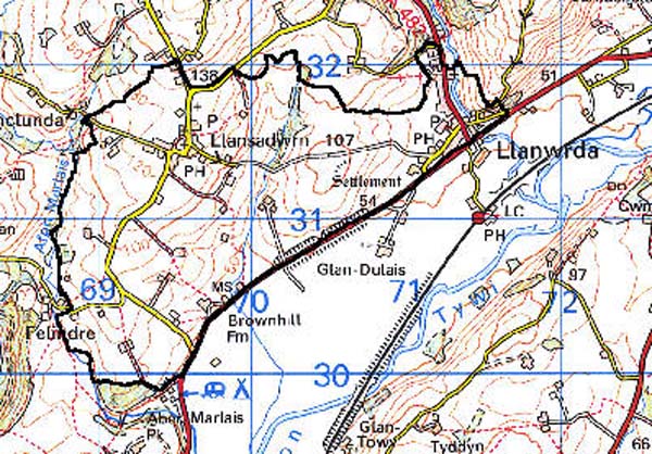
210 LLANSADWRN - LLANWRDA 
GRID REFERENCE: SN 701310
AREA IN HECTARES: 330.60
Historic Background
An area lying on the northwest side of the Tywi Valley. During the historic period the area has always been divided by an administrative boundary; the western half lay within Maenor Llansadwrn of the commote (and later hundred) of Maenordeilo, the late Medieval parish of Llansadwrn, while the eastern half lay within Gwestfa Llanwrda of the commote of Malláen, the late Medieval parish of Llanwrda and the later hundred of Caio (Rees 1932). Both commotes were held of the independent Welsh lordship of Cantref Mawr until the establishment of the county of Carmarthen in 1284. There is evidence of early settlement; an Iron Age hillfort lies within the area while the present churches of Llansadwrn and Llanwrda may both have possible pre-Conquest origins. The latter church lies close to the Roman road from Carmarthen to Llandovery, now represented by the A40(T), which forms the long southeast edge of this character area, while both have churchyards that were formerly circular (the former yard being very large). However, neither became a parish church until the late (or even Post-) Medieval period, prior to which they were both appendent to the large parish of Cynwyl Gaeo, itself probably a pre-Conquest unit, and in turn subordinate to Talley Abbey from c.1200 onwards (Ludlow 1998). There is no evidence for accompanying Medieval settlement; a maerdy place-name southeast of Llansadwrn village, derived from a reeve or maer, may be associated with the neighbouring, Medieval Abermarlais estate (Sambrook and Page 1995, 17) rather than a settlement around the church. Maenor Llansadwrn was regarded as possessing minor lordship status by the early 16th century when, along with the Abermarlais estate (Area 209) it was in the possession of the great Tudor magnate Sir Rhys ap Thomas (Sambrook and Page 1995, 21). His grandson and heir Sir Rhys ap Gruffydd was executed by Henry VIII for treason and 'the manor, lordship, hamlet and town of Llansadwrn' fell to the crown. The term town in this context presumably refers to a township or tref rather than a built-up area, and there are no records of any liberties associated with borough foundations. Neuadd Fawr, a large 17th century house just outside Llanwrda, is likely to have been a single development but may be the site of the Medieval llys of Gwestfa Llanwrda. Both nucleations are in fact likely to have origins in the 18th century and the Ordnance Survey Old Series 1" maps of the early 19th-century show them with only scattered development. Llanwrda received impetus for growth when the Roman road line was turnpiked in 1763-71 (Lewis, 1971, 43), when it shifted away from the church towards the road. Both villages received Post Offices in the late 19th century, and Llanwrda in particular has been subject to 20th century development. Fields are mainly fairly large and regular which may suggest Post-Medieval enclosure.
Base map reproduced from the OS map with the permission
of Ordnance Survey on behalf of The Controller of Her Majesty's Stationery
Office, © Crown Copyright 2001.
All rights reserved. Unauthorised reproduction infringes Crown Copyright
and may lead to prosecution or civil proceedings. Licence Number: GD272221
Description and essential historic landscape components
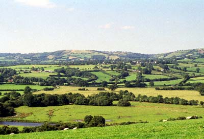
Llansadwrn - Llanwrda character area lies on the northern side of the Tywi valley, and includes: the very northern edge of the flood plain at about 45m, rising hills up to a maximum of 140m and the lower part of the Dulais valley in which Llanwrda village is situated. Essentially this area consists of two loosely nucleated villages - Llansadwrn and Llanwrda - dispersed farms and improved pasture enclosed into small irregular fields. Field boundaries are earth banks topped with hedges. Hedges are generally well managed, though some are becoming overgrown, and at higher levels some are derelict. There are distinctive hedgerow trees in some of the hedges. Most hedges are supplemented with wire fences. Small stands of deciduous woodland are mostly confined to steep slopes on minor valley sides. Llansadwrn is unusual, compared with other villages of the Tywi valley, in that it is situated on a rounded hill-crest rather than on a valley bottom. It consists of a loose girdle of houses around the Medieval church. The stone-built houses and cottages of the village seem mostly to be of 19th century date. The scattering of more recent housing, in a variety of styles, does not detract from the essentially 19th century character of the village. Llanwrda is a valley bottom village that has developed at the junction of two turnpike roads, the present A40(T) and the A482, with early- and mid-19th century housing in a variety of styles along the A482, with later 19th-century housing along the A40(T). The latter road has now been bypassed. Small modern housing estates have been established on the fringes of the village core. Dispersed farmhouses are mainly 19th century in date, and in the vernacular tradition, with outbuildings of modest size, sometimes compacted into one range. Most farms have an assemblage of modern agricultural buildings. The A40(T) passes along the southern boundary of this area, along the Tywi valley route corridor but, apart from Llanwrda village, linear development has not occurred along this road.
There is little recorded archaeology but time-depth is provided by the Iron Age hillfort and the Roman road. There is also a ffos place-name (possible boundary ditch) and a possible holy well site.
There are few distinctive buildings. Neuadd Fawr, Llanwrda, is a Grade II listed house, probably 17th century in origin with a massive chimney breast and later alterations. Llansadwrn Church is a Grade B listed landmark church, but neither church has a tower. Both villages feature chapels, schools, public houses and Post Office buildings, while Llanwrda also features an almshouse and a bridge. Farmhouses are mainly 19th century in date, stone-built, two-storey, and generally in the vernacular tradition. Stone outbuildings associated with the farms are of modest size. There is the usual scatter of Post-Medieval cottage sites.
This is not an easy area to define as neighbouring character areas share many of its historic landscape components. To the south the Tywi valley character area forms a reasonably distinct boundary, but to the west and east there is a zone of change rather than a hard-edged border. Areas to the north have yet to be defined, but here the landscape here is generally characterised by a more dense distribution of small farms, very small fields and woodland.