|

226 GARN-WEN 
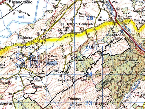
GRID REFERENCE: SN 700240 AREA IN HECTARES: 218.60
Historic Background
A small character area on the southeast side of the Tywi Valley between
Llandeilo and Llangadog, dominated by the large Iron Age hillfort of Carn
Goch (Area 222) which rises just beyond the northern edge of Area 226
and was probably the centre of a large territory taking in most of the
area south of the Tywi. During the historic period the area lay within
Cwmwd Perfedd - specifically Maenor Vabon - of Cantref Bychan, which was
invaded by the Anglo-Normans under Richard Fitz Pons who established a
caput at Llandovery in 1110-16 (Rees n.d.). It was acquired soon after
by the Clifford lords of Brecon as the Lordship of Llandovery. However,
there were many episodes of Welsh rule and the area retained native tenurial
customs until the end of the Medieval period when it was incorporated
into modern Carmarthenshire. The medium-sized irregular enclosures in
this area contrast with the larger, regular enclosures to the southeast
- which are 19th century enclosure of former common - and are probably
earlier, though possibly Post-Medieval. The area contains just three farmsteads,
all of Post-Medieval date. There has been little recent development but
there are pockets of later 20th century conifer plantation.
Base map reproduced from the OS map with the permission
of Ordnance Survey on behalf of The Controller of Her Majesty's Stationery
Office, © Crown Copyright 2001.
All rights reserved. Unauthorised reproduction infringes Crown Copyright
and may lead to prosecution or civil proceedings. Licence Number: GD272221
Description and essential historic landscape components
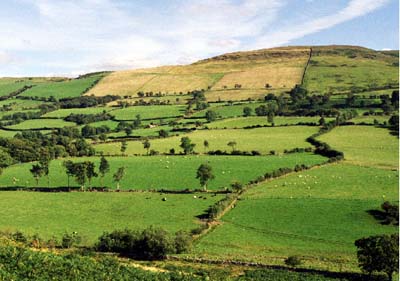
Garn-wen character area is relatively small but quite complex as
it lies between lower-lying farmland and a high unenclosed ridge. It has
an 'upland farm' character feel to it. It lies on northwest-facing slopes
between 190 m and 200 m. All the land has been enclosed, but fields at
higher elevations are now breaking down. Three farms, Gurnos, Garn-wen
and Tan-y-lan, lie within the area. The fields, though tending towards
the irregular, have a definite northwest-southeast trend to their axes,
perhaps indicating a single major episode of enclosure. Field boundaries
exhibit a variety of types; dry-stone walls, earth banks and stony banks.
The latter two are topped with hedges, which are in various stages of
decay; at higher levels they have virtually gone, at lower levels they
tend to be overgrown with distinctive hedgerow trees. Dry-stone walls
are mostly derelict. Wire fences provide stock-proof barriers. Most land
is improved pasture, but a medium-sized conifer plantation has been established
over some former fields. Farmhouses are stone-built, probably 19th century,
and have a substantial range of 19th century stone-built farm buildings
associated with them, as well as very extensive modern agricultural buildings.
Only one archaeological site - a palaeolithic findspot - has been recorded, but is important and provides great time-depth.
There are no distinctive buildings.
Garn-wen is a well defined character area. To the northwest lies either the unenclosed moorland of Carn Goch or lower-lying farmland, while on other sides is a high ridge of unenclosed land, or conifer plantations.