|

227 CYNGHORDY 
GRID REFERENCE: SN 783395
AREA IN HECTARES: 1322.00
Historic Background
A large area situated between the Afon Brân and the headwaters of the
River Tywi, once part of Hirfryn commote of Cantref Bychan which was invaded
by the Anglo-Normans under Richard Fitz Pons who established a caput at
Llandovery in 1110-16 (Rees n.d.). It was acquired soon after by the Clifford
lords of Brecon as the Lordship of Llandovery but retained native tenurial
customs until the end of the Medieval period when it was incorporated
within modern Carmarthenshire. Much of the area may have been unenclosed
during the Medieval period - Rees' 1932 map of 14th century South Wales
labels it 'Cefngelevarth Forest' (Rees 1932) - but the village of Cynghordy
may derive its name from a monastic foundation (undated), and/or a chapel,
'Capel Cynfab', while the nearby place name Maes Mynach suggests the presence
of land-holdings belonging to such a foundation (Sambrook and Page 1995,
18). The present pattern of fields suggests that the southern half of
the area was enclosed during the late Medieval or early Post-Medieval
period; the regular enclosures in the northern half may be later but the
present landscape was in place by the early 19th-century. Cynghordy Hall
may have 16th century origins (Jones 1987, 53) but Rees suggests that
the Medieval manorial centre of the area lay at 'Abergevel' to the south
(Rees 1932), and while he does mark a possible mill at Cynghordy, there
is no evidence that the present village is an early settlement alongside
a former church/monastery. It appears instead to have developed separately
alongside the Roman Road between Llandovery (Alabum) and the mid Wales
forts at Beulah and Castell Collen (James 1982, 7) - now represented by
the A483(T) just east of Area 227 - which became an important droving
route in the Post-Medieval period. The presence of a nonconformist chapel
and inn may be due to this association. The area is crossed by the railway
from Llandovery to Llanwrtyd Wells, which had been established by 1871
to form part of the London and North Western Railway (LNWR) Central Wales
and Carmarthen Junction Line, is still operational and forms part of the
'Heart of Wales' line. However, despite having the 'essential' requirements
of a chapel, post office and school, as well as a mill and industry represented
by a brickworks, a new parish church (Llanfair ar-y-bryn) constructed
in the late 19th-century, a vicarage, an inn and a railway station, nucleation
did not occur at Cynghordy - perhaps they were so dispersed that there
was no single focus around which a village could develop (Sambrook and
Page 1995, 24) and indeed, the most significant development has been the
construction of a 20th century council estate.
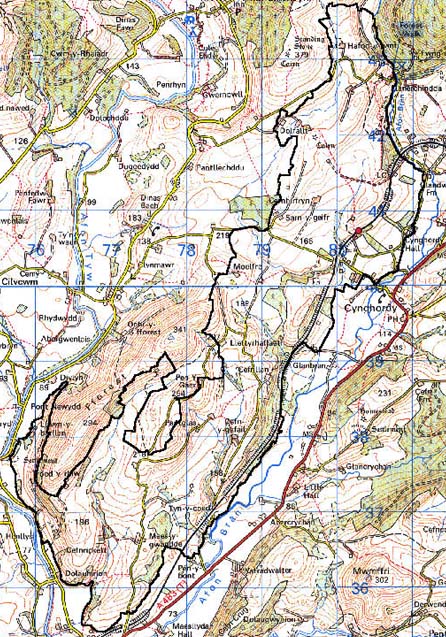
Base map reproduced from the OS map with the permission
of Ordnance Survey on behalf of The Controller of Her Majesty's Stationery
Office, © Crown Copyright 2001.
All rights reserved. Unauthorised reproduction infringes Crown Copyright
and may lead to prosecution or civil proceedings. Licence Number: GD272221
Description and essential historic landscape components
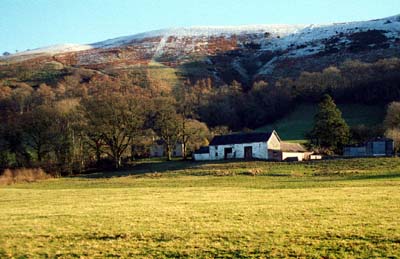
Cynghordy is a large character area which lies between 80m and 250m
on southeast-facing slopes on the western side of the Brân valley north
of Llandovery. It is essentially an area of small, irregular fields, dispersed
farms and scattered woodland. Boundaries are formed from earth banks topped
with hedges. Hedges are in a variety of conditions; at higher elevations
they are becoming derelict and/or overgrown, at lower levels, and alongside
tracks and lanes, they are in better condition and generally well maintained.
Most hedges are supplemented with wire fences. Many hedges contain distinctive
trees. These trees together with the numerous small stands of deciduous
woodland - mostly confined to steeper slopes - and many conifer plantations,
lend a wooded appearance to much of the landscape. Farmland is given over
to pasture, which is mainly improved, but there is rougher and rushy ground
in wet hollows and at higher levels. The settlement pattern is of dispersed
farms; Cynghordy is the only aggregate settlement and this consists of
a loose cluster of 19th century houses, chapels, a school and a street
of 20th century housing. Farmhouses are almost entirely late 18th- and
19th-century, stone-built, two-storeys and of three bays, though larger
and smaller examples are present. Most are in the vernacular tradition,
but there examples in the more 'polite' Georgian style. Nineteenth century
outbuildings to the farms tend to be of one or two ranges, though larger
farms have a greater range of buildings in a semi-formal arrangement with
the house. Most farms have a large range of modern agricultural buildings.
Though the Brân valley is an important routeway linking Carmarthenshire
to mid-Wales, most of the actual routes, from a Roman road to the modern
road, pass up the eastern side of the valley. The exception to this is
the mid-Wales railway which passes through this area, with a station at
Cynghordy, gaining in height from south to north. Its impressive stone-built
viaduct which just lies within the north side of the area, is a major
feature in the landscape.
Recorded archaeology is rich and diverse, comprising two definite and two possible Bronze Age round barrows, a possible Iron Age hillfort, a possible Medieval holy well and chapel and/or monastery site, and a number of separate findspots from the Neolithic, Bronze Age, Roman (possible) and Post-Medieval periods.
There are a few distinctive buildings. Parts of Cynghordy Hall, which is Grade II listed, date to the 18th century (Jones 1987, 53). The viaduct carrying the LNWR line is from c.1871 and Grade II listed. In addition there are the post office, railway station, brickworks, St Mary's Church and vicarage, school, chapels, and mills, none of which are listed.
Character areas to the east and north of Cynghordy have yet to be defined. To the west a high ridge provides a reasonably good boundary to this area, but to the south, there is a zone of change rather than a hard-edged border.