|

268 MAENCLOCHOG 
GRID REFERENCE: SN082279
AREA IN HECTARES: 221.1
Historic Background
A small area of modern Pembrokeshire, on the southern edge of Mynydd
Preseli, within the medieval Cantref Cemaes. Cemaes was brought under
Anglo-Norman control in c.1100 by the Fitzmartins who retained it, as
the Barony of Cemaes, until 1326 when they were succeeded by the Audleys.
The Barony was conterminous with the later Hundred of Cemais, which was
created in 1536, but many feudal rights and obligations persisted, some
until as late as 1922. The Maenclochog character area belonged to the
mesne lordship or manor of Maenclochog, held from the Barony of Cemaes
by the Roche lords of Llangwm in the 13th- and 14th-century, when it was
assessed at one knight's fee, but unlike most of the manor, this character
area - which comprises the settlement at Maenclochog itself - was held
under Anglo-Norman manorial tenure. The medieval history of the manor
is known only in outline. It had been obtained by the Roche lords of Llangwm
by the mid 13th-century, along with knight's fees at Monington and Llanychaer,
and their tenure continued into the 14th century. In a later Extent, from
1594, the manor of Maenclochog was, like others in Cemaes, held on an
annual lease from the Barony, this one being assessed at 3s 8d. A castle
had been founded by 1215 when it is mentioned in the Chronicles as having
been destroyed in a Welsh raid. It was 'destroyed' again in 1257 while
a reference in an Inquisition of 1376 may imply that it was still in use.
The location of the castle has yet to be demonstrably proved, but the
rocky knoll with its accompanying enclosure at the southern end of the
village is a strong candidate. North of the site is a large, square green
containing the church, which leads into an axial main street - now the
B4313 - which is lined by tofts. All are classic features of Anglo-Norman
planted settlement in Pembrokeshire and Maenclochog forms part of a chain
of such plantations along the southern foothills of Mynydd Preseli (cf.
New Moat, Henry's Moat, Hayscastle etc.). However, there is no evidence
that Maenclochog ever achieved, or aspired to borough status. The church
has been entirely rebuilt but it was a medieval foundation, with a 'Mary'
dedication which may imply that it is has post-Conquest origins. The vicarage,
with its chapelries of Llandeilo Llwydarth and Llangolman, were granted
to St Dogmael's Abbey by David de la Roche in c.1320. The long, narrow
fields that surround the village are characteristic of the enclosure of
medieval field-strips, probably divided along Anglo-Norman manorial lines,
but the later history of the village has, in contrast, been predominantly
Welsh, and pastoral. It was also comparatively poor, no holding being
assessed for more than two hearths in 1670. By the 19th century, it was
a drovers' centre and a large annual cattle fair was being held on the
green. A map of 1773 shows the green with 15 dwellings around it, while
the remainder of the landscape was much as today. The area was crossed
by the Maenclochog Railway which was opened in 1876 to serve the quarries
at Rosebush in Mynydd Bach character area. It was later extended to Fishguard,
but closed in 1949.

Base map reproduced from the OS map with the permission
of Ordnance Survey on behalf of The Controller of Her Majesty's Stationery
Office, © Crown Copyright 2001.
All rights reserved. Unauthorised reproduction infringes Crown Copyright
and may lead to prosecution or civil proceedings. Licence Number: GD272221
Description and essential historic landscape components
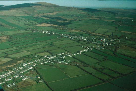
Maenclochog historic landscape character area lies on gentle south-facing,
southern slopes of Mynydd Preseli between 200m and 260m. It is centred
on Maenclochog village. Agricultural land comprises a system of long narrow
fields; this is clearly an open field system which has been enclosed.
The enclosed strips are best preserved to the east and north of the village.
Field boundaries consist of earth banks and stony banks topped with hedges.
Apart from alongside roads and tracks, hedges are not generally well maintained.
Many have gaps in them and others are overgrown. Other than a small 20th
century coniferous plantation and trees in some of the overgrown hedges,
woods do not form a characteristic element of this landscape. Maenclochog
retains the character of a working agricultural village with farms, a
church, chapels, garage, village hall, public houses, workshops, houses
and shops. The village is planned around a rectangular green on which
the parish church is located. Houses and other buildings are located around
the outside edge of this green. Dwellings are in a variety of styles and
materials. The older examples date to the early- to mid- 19th-century,
with both detached farmhouses, other detached houses and terraces present.
All are stone-built (cement rendered and bare stone) and most are two
storey with three bays. Examples in the vernacular and polite Georgian
tradition are present. Mid 20th-century construction includes houses,
bungalows and cottages, including a good single storey timber-framed corrugated-iron
example. Later 20th-century linear development is present alongside the
roads to the north, west and east. There is a small, 21st century housing
estate on the northern fringes of the village. Dispersed settlement outside
the village comprises farms, the houses of which are generally 19th century
in the vernacular tradition. Farm buildings of the village- and dispersed-farms
are a mixture consisting of: one or two ranges of 19th century stone-built
structures; mid 20th-century corrugated tin barns and other buildings;
and late 20th-century steel, concrete and brick structures. The only listed
building is St Mary's Church, which was entirely rebuilt in c.1790, in
the same location as its predecessor but retaining none of the earlier
fabric. Other buildings include the early 19th-century Hen Gapel in the
centre of the village, and Tabernacle, built as an independent chapel
in the mid 19th-century after a dispute between the congregation at Hen
Gapel. Transport elements of the historic landscape comprise the B4313
which runs north-south through the village, minor roads and lanes, and
an abandoned railway line.
There is a wealth of prehistoric archaeology within this small area, including a neolithic/bronze age ritual complex at Eithbed, with a number of chambered tombs and possible standing stones, another group of two standing stones and two more isolated standing stones. The context of the 'bell-stones' mentioned by Fenton - two stones said to ring like a bell when struck - is unknown and they are now gone. There is an iron age hillfort and a smaller defended enclosure.
The Early Christian Monuments in St Mary's Church are from Llandeilo Llwydarth, but there is a holy well site. The location of the castle has yet to be demonstrably proved, but the rocky knoll with its accompanying enclosure at the southern end of the village is a strong candidate. Maenclochog is a distinctive historic landscape character area. It contrasts with Mynydd Bach Parliamentary enclosure to the east and with the undefined areas of larger, more regularly enclosed land to the south and west.
Sources: Dyfed Archaeological Trust 1997; Fenton 1811; Gale 1992; Green 1924; Howells 1977; Jones 1952; King 1988; Ludlow 1998; Maenclochog tithe map and apportionment, 1841; National Library of Wales, Picton Castle 1; Owen 1897