|

296 ST DAVID'S AIRFIELD 
GRID REFERENCE: SM789257
AREA IN HECTARES: 161.1
Historic Background
An area of modern Pembrokeshire, until recently occupied by an airfield,
on the south side of St David's Peninsula. It lay within the medieval
Cantref Pebidiog, or 'Dewisland', which was held directly by the Bishops
of St David's, having represented the core of the bishopric from 1082
when it was granted (or confirmed) by Rhys ap Tewdwr, king of pre-Conquest
Dyfed, to Bishop Sulien. From 1115, when Bernard was appointed Bishop
of St David's, Anglo-Norman systems of feudal government and ecclesiastical
administration were introduced into Pebidiog, which was conterminous with
the later Hundred of Dewsland created in 1536. This character area belonged
to the 'manor' of Crughely, but Welsh tenurial systems appear to have
persisted, though variously adapted, and many feudal rights and obligations
continued even into the early 20th-century. The character area contained
the vills, and later farmsteads of Llechell and Treflodan but also contained,
until 1943, part of the large unenclosed belt of informal waste or 'moor'
(Waun) that now forms the Waun Caerfarchell character area and was divided
between at least five medieval/post-medieval vills, each of which had
rights to a portion. No physical distinction between these can now be
defined, but the attribution survives in their names Waun Vachelich, Waun
Llandruidion, Waun Llechell, Waun Treflodan and Waun Caerfarchell. The
vill of Vachelich appears in the Black Book of St David's of 1326, but
Caerfarchell, Llandruidion and Treflodan do not and may be 14th- or 15th-century
in origin, while Llechell is not mentioned until the mid 16th-century,
which may suggest a post-medieval date for its origin, or at least the
division of the common. The airfield was established over the area in
1943 for RAF Coastal Command and was still at operational readiness, but
not in use, in 1993. In the late 1990s the buildings were largely demolished
and the land was restored to grass. The area is the venue for the 2001
National Eisteddfod.
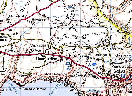
Base map reproduced from the OS map with the permission
of Ordnance Survey on behalf of The Controller of Her Majesty's Stationery
Office, © Crown Copyright 2001.
All rights reserved. Unauthorised reproduction infringes Crown Copyright
and may lead to prosecution or civil proceedings. Licence Number: GD272221
Description and essential historic landscape components
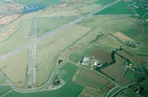
This relatively small historic landscape area lies on a plateau at approximately
70m to 75m. A second world war airfield was established here. All the
airfield buildings are now demolished and much of the land restored to
pasture, but stretches of the concrete runways and service roads survive.
No attempt has been made to restore the field pattern which existed prior
to the airfield. Some long field banks constructed from bulldozed rubble
run across the area, and there are mounds of rubble from demolished buildings.
However, this is an open landscape of restored pasture divided by wire
fences. There are no settlements. Occasional buildings dating to the second
world war survive outside the southern limits of this area. There are
no standing buildings within the area.
Recorded archaeology is limited to a possible bronze age standing stone site, an iron age findspot and the vill/farmstead sites of Llechell and Treflodan.
St David's airfield historic landscape character area is distinctive and contrasts sharply with the pattern of old established farms and fields which lie to the west, south and east, and with unenclosed common to the north.
Sources: Charles 1992; James 1981; Thomas 1997; Whitechurch (St David's) tithe map and apportionment, 1840-41; Willis-Bund 1902