Home > Historic Landscape Characterisation > Drefach-Felindre > |

 SARON - RHOS
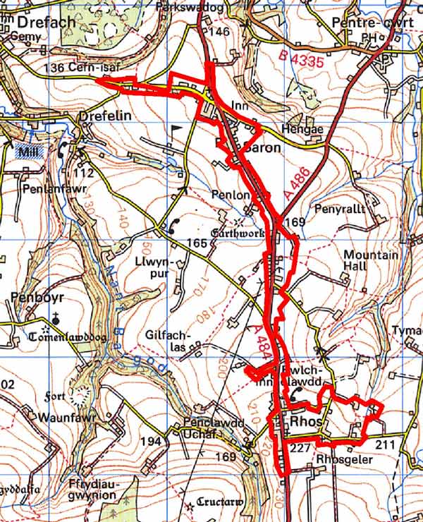
GRID REFERENCE: SN379367
AREA IN HECTARES: 82
Historic Background
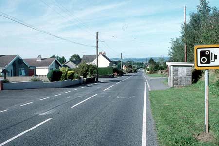
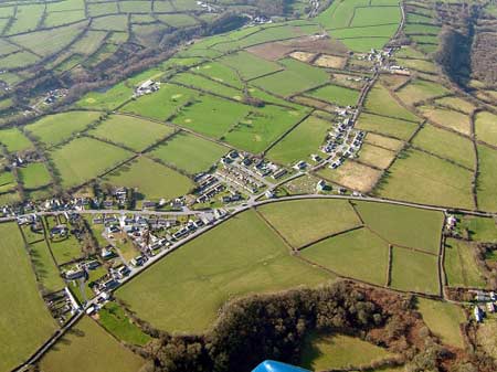
A small area within modern Carmarthenshire, comprising a narrow corridor either side of the present A484, which runs north-south through the surrounding character area of Llangeler. The road has been subject to 20th century ribbon development, between the two 19th century settlements of Saron and Rhos. The area lies within the medieval Cantref Emlyn, in Emlyn Uwch-Cych commote. Cantref Emlyn had been partly brought under Anglo-Norman control in c.1100 when Emlyn Is-Cych commote, to the west, was reconstituted as the Lordship of Cilgerran. Numerous castles were established in Uwch-Cych - none of which have any recorded history - but the commote was back under Welsh control by the 1130s, and remained such throughout the 12th and early 13th centuries. It was appropriated by the Anglo-Norman Marshal Earls of Pembroke in 1223, but was granted to Maredudd ap Rhys, with whose family it remained until finally annexed by the English crown in 1283. In 1536, it eventually formed part of the Hundred of Elvet in Carmarthenshire, , when Is-Cych joined Pembrokeshire. Uwch-Cych was granted to royal favourite Sir Rhys ap Thomas in the late 15th century, reverted to the crown in 1525, and was granted in 1546 to Sir Thomas Jones of Haroldston, Pembrokeshire. It remained in this family for several generations, eventually passing by marriage to the Vaughans’ Golden Grove Estate, which in the 19th century still owned almost all the land on the southern side of the Teifi from Pentre-cwrt in the east to Cenarth in the west. The medieval Welsh tenurial pattern - with neither vills nor knight’s fees - has been largely responsible for the dispersed settlement within the region. Indeed, this character area represents one of the most built-up areas within Uwch-Cych, but the development is all of a very late date. In 1839, four buildings were recorded at Saron, close to the A484, which was a newly constructed as turnpike in the late 18th century. The buildings include Saron Chapel, established in 1792, which was clearly a primary feature and from which the settlement derives its name. The buildings are in a landscape of fields and dispersed farms, which follow the axis of the road and appear to be contemporary, late 18th century enclosure The landscape at Rhos is different. Here at the higher end of the character area close to open moorland a pattern of scattered cottages set in small irregular fields is seen. These were probably established as squatter settlements or tai unnos on the fringes of common land in the late 18th century or early 19th century. Settlement expanded gradually throughout the 19th century, and by the beginning of the 20th century a small church, an independent chapel and a Sunday school were established at Rhos, along with further dwellings at both Rhos and Saron. These settlements were then still very small. The last three decades of the 20th century have seen a rapid expansion of the settlements which has resulted in an almost continuous linear development of houses and bungalows along the old turnpike road/A484.
Description and essential historic landscape components
This is a roadside linear character area very much dominated by late 20th century housing, but with some older elements. It fringes the A484 road on gentle north-facing slopes between 160m above sea level at Saron and up to 230m above sea level at Rhos. At Rhos there is a fairly tight distribution of late 19th century stone built, two storey cottages and houses. Some have small agricultural buildings attached or close to them indicating their agricultural origin. Stone is the traditional building material, with Teifi valley slate – laid as uncoursed rubble – more common at lower levels close to the Teifi, and locally-sourced stone more common at higher levels towards the southern end. Of the character area. Two small late 19th century chapels and a Sunday school are also located here. Modern housing, particularly bungalows, infills much of the space between the older house along the main road. Saron was originally focused on the main road where some of the older buildings including stone-built and cement rendered terraces of two storey worker cottages and a substantial late 19th century chapel can be found. A 20th century school is also located here. However, modern housing alongside the main road and on side lanes now dominates the settlement, forming virtually unbroken development on the A484 from Saron to Rhos. Although this area is chiefly non-agricultural, some agricultural historic landscape components are included including: Lleiniau, a late 18th century house with in-line outbuildings and an early 20th century house; farmhouses dating to the mid to late 19th century in the typical southwest Wales style – stone-built, two storey and three-bay with a central front door and five symmetrically arranged windows - associated with one or two ranges of stone outbuildings, and fields with hedges on earth banks. There is no recorded archaeology.
Saron – Rhos is defined by modern development. Modern housing, particularly in clusters or linear developments is rare in the neighbouring historic landscape character areas.
Sources: Craster, O E, 1957, Cilgerran Castle, London; Jones, D E, 1899, Hanes Plwyfi Llangeler a Phenboyr, Llandysul; Llangeler parish tithe map 1839; Lewis, S, 1833, A Topographical Dictionary of Wales 1 & 2, London; Lloyd, J E, 1935, A History of Carmarthenshire, Volume I, Cardiff; Rees, W, 1932, ‘Map of South Wales and the Border in the XIVth century’; Rees, W, 1951, An Historical Atlas of Wales, London; Regional Historic Environment Record housed with Dyfed Archaeological Trust
Base map reproduced from the OS map with the permission
of Ordnance Survey on behalf of The Controller of Her Majesty's Stationery
Office, © Crown Copyright 2001.
All rights reserved. Unauthorised reproduction infringes Crown Copyright
and may lead to prosecution or civil proceedings. Licence Number: GD272221