Home > Historic Landscape Characterisation > Milford Haven Area > |

MILFORD HAVEN 
GRID REFERENCE: SM 904063
AREA IN HECTARES: 492
Historic Background
This is an urban area. Until recently this area lay mainly within the
parishes of Steynton and Hubberston. It occupied the medieval Manor of
Pill, part of the larger Manor of Pill and Roch which was created between
1100 and 1130. Its relationship with the Lordship of Haverford, within
which it lay, was always a matter of dispute. Pill was a large and important
manor, encompassing the modern town of Milford Haven. The Tironian Pill
Priory was founded, at the head of Hubberston Pill (pill is a local term
for a tidal inlet), by the lord of Pill and Roch in the late 12th century.
Both Hubberston church and the former St Catherine’s chapel, beneath
modern Milford Haven, were dependencies. At the dissolution the area was
acquired, with the priory, by the Barlows of Slebech, in whose hands it
remained until 1758 when Catherine Barlow married Sir William Hamilton,
founder of the ‘proprietary town’ of Milford Haven in 1790.
Documentary sources prior to this date clearly indicate an increase in
economic activity in and around the Milford Haven waterway from the 16th
century. The strategic military importance of the Milford Haven waterway
had been recognised as early as 1538 when Thomas Cromwell recommended
that forts should be constructed for its defence. Naval ships were frequent
visitors to the Haven’s sheltered waters, as a painting by J R Attwood
of 1776 in the National Museum of Wales showing the British fleet at anchor
in Hubberston Road testifies. The absence of a major settlement to supply
not just these naval ships but also coastal and long-distance traders
was of serious concern by the mid 18th-century. The nearest customs house
was at Pembroke and there were no piers, quays or hotels close to deep-water
anchorages. The lack of hotels was a particular problem for the passengers
of the packet service that was running on a regular basis between Hubberston
and Waterford in Ireland. Up to the late 18th-century Hubberston was a
village where fishing was probably its major economic activity. Smaller
settlements developed around other sheltered creeks, such as Castle Pill
and Neyland Pill. With this level of naval and economic activity it is
hardly surprising that from 1764 William Hamilton was formulating development
plans. In 1790 an Act of Parliament granted him permission to: ‘make
and provide Quays, Docks, Piers and other erections and establish Market
with proper Roads and Avenues’. In 1796, the Navy Board located
a dockyard near the entrance of Hubberston Pill; seven ships were built
here before it was relocated to Pembroke Dock. Two small forts built to
protect the dockyards continued in use into the early years of the 19th
century. Jean Louise Barrallier, the man responsible for the ship building-programme,
probably designed the grid pattern of Milford Haven town. In 1792, a small
community of Nantucket whalers were persuaded to settle in the new town,
and for a short time, until a collapse of the price of sperm whale oil
in 1819, a successful whaling industry operated. No evidence of the dockyards
or of the whaling industry survives. Several plans were proposed for the
construction of quays, piers and all weather docks in the first half of
the 19th century, but nothing was done. The transference of the Irish
steam packet service from Milford Haven to Hobbs Point on the opposite
side of the waterway depressed the struggling town, as did the construction
of a railway to Neyland in 1856, although a spur line was opened to Milford
Haven in 1863. In an attempt of kick start the town to life the Milford
Improvement Bill of 1857 led to the construction of a pier and two wooden
bridges: Black Bridge and Hakin Bridge, both now replaced by modern structures.
Small shipbuilding yards operated in Hubberston Pill and on the site of
the earlier naval dockyards in the mid-to-late 19th century, 13 ships
being built between 1867-74. In 1872, the cast iron pier of Newton Noyes
was opened, linked by a railway. In 1934, the Admiralty acquired the pier
as part of their mine depot at Blackbridge. Finally, after many false
starts, Milford Haven Docks were opened in 1888, with dry-dock facilities
in Castle Pill. The docks were intended for the transatlantic passenger
trade, but only one liner ever called, and this was too large to use the
docks. Instead a successful fishing fleet developed. Sheds designed for
the transatlantic trade were converted to a fish market in 1890, and these
were extended in the 1930s. Ice factories were constructed in 1890 and
1901. A mackerel quay and market were built in the early 1900s. All these
structures have now gone. By 1922 there were five herring smoking houses
in and around the docks. One of these survives. The fishing industry survived
World War 2, but went into severe decline in the later 1950s. There are
now no locally-owned fishing boats operating out of Milford Haven. The
majority of the old dockside buildings have been demolished and the docks
converted to a marina. During the 19th century and 20th century, the increase
in population in conjunction with greater economic activity contributed
to the spred of housing and other development across what had been fields
and farms on the outskirts of the town. For instance early 19th century
maps show a regular pattern of fields to the east of Hubberston Pill with
the small settlement at Hubberston called the ‘Town of Hakin’.
Large-scale housing development now lies across these former fields. Similar
patterns of housing and infrastructure developments lie to the north and
east of the town centre. To the east of Castle Pill little development,
apart from the massive mine depot at Blackbridge, took place until the
late 20th century when houses were constructed on former parkland at Castle
Hall.
Base map reproduced from the OS map with the permission
of Ordnance Survey on behalf of The Controller of Her Majesty's Stationery
Office, © Crown Copyright 2001.
All rights reserved. Unauthorised reproduction infringes Crown Copyright
and may lead to prosecution or civil proceedings. Licence Number: GD272221
Description and essential historic landscape components
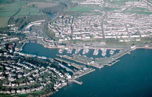
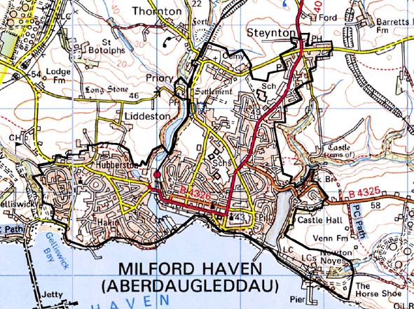
The town of Milford Haven lies on the north bank of the Milford Haven
waterway. The historic late 18th century and 19th century core of the
town which is based on a grid pattern is located between Hubberston Pill
and Castle Pill and inland for no more than 500m. However, the town expanded
during the second half of the 20th century and now includes the older
settlements of Priory (Pill Priory), Hubberston and Steynton. The latter
is centred on a medieval church, but the village character of the settlement
is now lost under extensive housing development. At Hubberston a loose
collection of late 18th century and 19th century houses (including Georgian
houses) and commercial buildings and quays and jetties testify to the
pre Milford Haven town importance of the settlement. Priory, with the
remains of the Tironian church, a pub and 19th century stone built cottages
retains a rural village atmosphere despite its proximity to the town.
Stone, generally cement rendered, and slate for roofs are the chief building
materials of the older buildings. These include three storey domestic
and commercial properties, mainly in the Georgian style, set along the
northern side of the main road through the town and overlooking the harbour
and waterway. Other 19th century houses in the historic core are more
modest, generally two storey. The traditional commercial centre of the
town was extensively rebuilt in the mid-to-late 20th century, although
it retains the earlier grid pattern. A shopping complex built over the
in-filled Hubberston Pill, close to the railway station, has supplemented
it. The imposing structure of the Torch Theatre, a late 20th century building,
dominates the western end of the town. A large part of the docks has been
converted to a marina. Many of the late 19th and early 20th century buildings
associated with the original docks have been demolished, although a few
survive particularly at the western end, which still retains its commercial
function. A museum is housed in one of these older buildings and other
tourist facilities are located within the docks. Later 19th century and
early 20th century housing – mostly stone built terrace houses –
and other developments lie to the north of the town’s core. Extensive
later 20th century housing estates to the west at Hakin are prominent
components of the landscape. Infrastructure development such as schools,
a leisure centre and industrial estates accompany the 20th century population
expansion. It is only in recent years that housing development has spilled
across farmland to the eastern side of Castle Pill. Here some of the larger
buildings of the now closed Blackbridge mine depot have been converted
for leisure uses. Milford Haven has 122 listed buildings. Most of these
are accounted for in the domestic and commercial properties described
above, but also included is the massive mid 19th century structure of
Fort Hubbeston and minor industrial remains such as limekilns. Close to
Fort Hubbeston is the headquarters and jetty of the Milford Haven Port
Authority.
Milford Haven is a well-defined historic landscape character area and contrasts with neighbouring farmland.
Sources: Ludlow 2002; McKay n.d.; Rees 1957; Hubberston Tithe Map 1840;
Stainton Tithe Map 1843; PRO D/RKL/1194/13: PRO D/RKL/1194/9