
CARDIGAN
(Click here for a copy of the full report)
SUMMARY
In the early twelfth century the Anglo-Normans established a castle at Cardigan outside the gates of which a settlement, later a town, rapidly developed. The Welsh attacked the castle and town on numerous occasions, most famously in 1136. However, the town thrived and 110 burgesses lived within the walled town of Cardigan in 1268. The town declined in the late thirteenth century and did not recover until the post-medieval period. Stratified archaeological deposits from the medieval period and later have been recorded in several small-scale archaeological investigations in the town, but there have been no substantial excavations.
KEY FACTS
Status: Borough. 1284 town charter. Weekly market and annual fair.
Size: 1268 130 burgages.
Archaeology: Medieval deposits have been recorded in several small-scale interventions.
LOCATION
Cardigan lies on the southern boundary of Ceredigion on the lowest bridging point of the River Teifi, approximately 3km from the open sea (SN 178 461). Good communication routes are provided to the north into the coastal areas of Ceredigion, to the south to Haverfordwest and Fishguard and along the Teifi valley to the east
HISTORY
In 1093 Roger of Montgomery invaded Ceredigion and established a castle on the Teifi estuary. The exact location of his castle is uncertain but many writers have identified the earthworks at Old Castle Farm 1km downstream of Cardigan with Roger’s castle. While this is possible, it is equally possible that Roger’s castle was on the site of the current Cardigan Castle. His castle was abandoned following his death in 1094. In about 1110 Gilbert fitz Richard reconquered Ceredigion and built a castle at Cardigan. Within a few years a settlement developed and a church founded – the beginnings of Cardigan town. The Welsh, disposed of their lands, fought back and attacked the castle and town on several occasions. The attack of 1136 was particularly bloody, with men, women and children of the town slaughtered. The castle did not fall. Contemporary records reveal the presence of a bridge at this date. In 1165 Rhys ap Gruffudd captured Cardigan making it a Welsh community. This was rare as the Welsh were not urban dwellers. In the later twelfth century and early thirteenth century Cardigan oscillated between Welsh and English control until 1241 when it came under direct English royal control.
Gilbert fitz Richard founded a Benedictine Priory with the associated church of St Mary at Cardigan in about 1115 on land to the east of the castle. It was dissolved in 1538. Cardigan was provided with a second church, Holy Trinity, the location of which has been much debated as nothing of it now survives, with many authorities placing it outside the town. However, a convincing case can be made for it to be located on the marketplace within the town. A hospital, known as Maudlyns Hospice, was recorded on St Mary’s Street; it was abolished in 1536.
Edward I granted a town charter to Cardigan in 1284 which reiterated the right to hold a market and fair. Cardigan’s grant of murage, that is the right to protect the town with walls, dates to 1281. However, the town was certainly defended by this date and so this grant would have been to extend existing defences or translate pre-existing earth and timber defences to stone. Edward’s intention was that these two grants would encourage immigrants to the town and spur growth.
Our knowledge of the extent of Cardigan comes from two surveys, 1268 and 1301. The 1302 survey being the most detailed. In 1268 130 burgages were recorded with 15 of them lying outside East (or Wolf) Gate, between the gate and the priory; three outside Bridge Gate and four in Fenny Street, a low lying area to the east outside town defences. Burgesses numbered about 110, with several individuals having acquired several burgages: Walter Blakeney had five and a half and John the Welshman had four and a half.
By 1301 about the same number of burgages and burgesses were recorded as in 1268, but some changes in the layout of the town had taken place with ten fewer burgages within the town walls. Several burgesses held more than one burgage, with Walter Blakeney, later Constable of Cardigan Castle, holding a block of nine on High Street paying 8d extra for ‘pro duobus capitibus domus sue’ which probably translates as a house with two turrets. Some parts of the town contained vacant plots as a few years earlier, in 1298-1300, sixty-eight burgages were recorded empty.
In common with other towns the plague of 1348-9 would have had a devastating impact on the town. Cardigan slowly declined. During the fifteenth century the number of burgages available for rent had decreased or were recorded as vacant and decayed.
John Speed’s 1610 map shows about 110-120 houses within the walled town. None are shown on Chancery Lane/Souters Street and several on the west side of High Street at the northern end are shown ruinous. Over a hundred houses lie along several streets between the East Gate and St Mary’s Church, and about ten houses lie outside the North Gate. Overall Speed’s map shows a well-populated town, albeit with some pockets of vacant plots; this is difficult to reconcile with a later seventeenth century account which reports Cardigan ‘enhabited the number of fyti and five households and as many and more decaye and late habitations’.
MORPHOLOGY
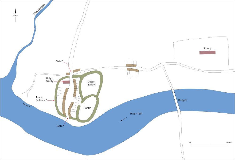
Cardigan Castle dominates the south end of the town, although much of what is visible from the outside is the result of nineteenth century rebuilding. Despite archaeological investigations during recent restoration works there are many unresolved issues with the castle – the main gate is assumed to be on the northwest side; what was the status of the open area between the Castle and St Mary’s Street? Could the earliest settlement which developed soon after 1110 have been here?

Map showing Cardigan as it may have been in 1136.
We know that when the Welsh attacked in 1136 the castle was firmly established, a town had developed, there was a bridge over the Teifi (perhaps upstream of its present location) and the priory was probably in existence as was Holy Trinity Church. It is also likely that the town was defended. Building plots to the west and northwest of the castle are irregular and small, the result of unplanned, organic development in the early twelfth century, and contrast with the more regular burgage plots to the north along High Street and to the west along Quay Street – these were planned and laid out later in the twelfth century or during the thirteenth century.

Map showing Cardigan as it may have been in c.1320. Note some of absence of houses in some of the burgages.
Analysis of the 1268 and 1301 surveys provides a clearer picture of the topography of the town. By this time the town wall and gates had been in place for several decades. These were to some extent dictated by topography; they survive particularly well to the east where they are designated a scheduled monument and elsewhere their course has been fossilised in property boundaries and can be traced with a high degree of confidence. The location of the town gates has been established, although nothing now survives of them above ground. It is not always possible to reconcile the number of burgages recorded in medieval surveys with the topography. Holy Trinity Church probably lay close to the High Cross and marketplace – there are reports of burials being found in this area. Apart from burgages on St Mary’s Street towards the priory and few more outside Bridge Gate and in Fenny Street the whole of the population of Cardigan lived in houses within the town walls. Given that the town suffered depopulation from the 1340s it is likely that areas within the town walls remained deserted throughout the later medieval period. However, at least by the early seventeenth century possibly earlier, houses had been constructed outside the walled town to the east, towards the priory/St Mary’s Church. Since then the town has expanded to the west, north and east and across the river to the south.
