
CARMARTHEN
A full report for Carmarthen has not been produced
SUMMARY
The Romans founded a town at Carmarthen in the second century AD. This was deserted by the early fifth century, but by the late medieval period a small urban settlement later known as ‘Old Carmarthen’ had come into existence. This was eclipsed by ‘New Carmarthen’, an early twelfth century Anglo-Norman town. The town prospered, a friary and priory were founded, and the town was provided with defences. Throughout the medieval period Carmarthen was the largest and most important town and port in Wales.
KEY FACTS
Status: Charter, weekly market, two annual fairs.
Size: 281 burgesses in 1300 (plus 87 burgesses de vento). Carmarthen was the largest and most important town in Wales during the medieval period.
Archaeology: Large-scale excavations at the castle, priory and friary revealed rich, complex archaeological deposits. Small-scale excavations elsewhere have not produced the same quality of evidence.
LOCATION
Carmarthen is located on the north bank of the River Towy, at the lowest bridging and highest tidal point (SN 413 200). The Towy valley provides a good communication route to the northeast into mid-Wales.
HISTORY
Carmarthen has the most complex history of anywhere in southwest Wales, entirely fitting for one of only two Roman towns in the country and the largest and most important town in Wales in the medieval period. The complexity is compounded by there having been two medieval towns: Old Carmarthen and New Carmarthen. It is also the town that has been most extensively archaeologically investigated in the region.
Carmarthen is the only place in southwest Wales that can claim to have a Welsh, that is pre-Anglo-Norman, settlement approaching a town – later known as Old Carmarthen – but its exact location, size and character is unknown. The few historical sources for Old Carmarthen record a market (this was disputed by the burgess of New Carmarthen, as were other rights; land disputes between Old and New Carmarthen rumbled on into the sixteenth century). One hundred shillings in rent payable recorded in the late twelfth/early fourteenth century could equate to 100 burgages, a sizable settlement for the time. The religious house dedicated to St Teulyddog, probably located immediately to the east of the former Roman town, was closely connected with this settlement.
Henry I established a castle at Carmarthen in c.1106 as a centre of English Royal power and government in southwest Wales. Henry chose a bluff overlooking the River Towy for his castle, several hundred metres to the southwest of the old Roman town of Moridunum and of the Welsh settlement that became known as Old Carmarthen.

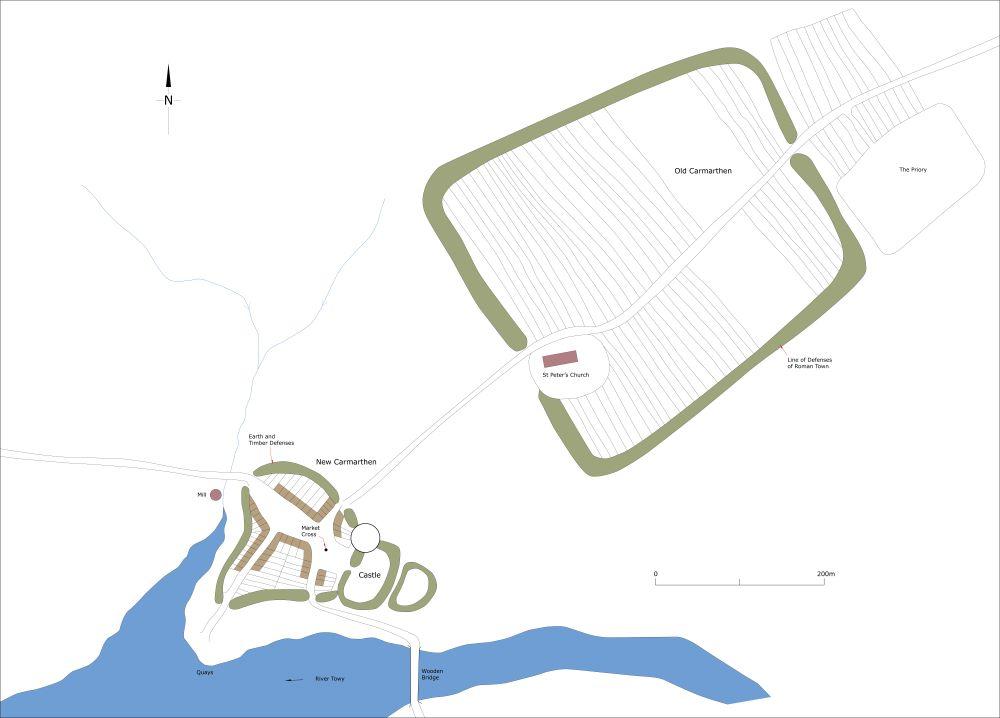
Map showing Old and New Carmarthen as they may have been in c.1150.
Immigrants would have been invited to settle in what became New Carmarthen soon after the foundation of the castle. This nascent town developed outside the gates of the castle and is first mentioned in 1116 when the Welsh attacked and burnt it and the castle. The following century was one of repeated Welsh attacks on the town and castle, 1137, 1146, 1159, 1196 and 1214. In the last one, the town’s inhabitants torched the town themselves in preference to it falling into Welsh hands.

Map showing New Carmarthen as it may have been in 1268.
Despite these setbacks Carmarthen flourished, largely due to rights and privileges conferred on the townspeople by Henry II, later confirmed by King John, and by a charter of 1256-7. The town had a weekly market and two annual fairs, one on 1st August. A bridge over the Towy had been built by 1220 and in 1233 the town was granted the right to erect a town wall – this was almost certainly a replacement of earth and timber defences that must have been built to protect the town in its first years of existence. Carmarthen developed into an important port, declining towards the end of the medieval period due to silting of the river leading to larger ships having to unload at Green Castle several kilometres downstream of the town. Four mills served the town.
The spiritual life of the townspeople was not neglected. There is evidence that St Peter’s Church, located on the east gateway of the old Roman town, was in existence prior to the eleventh century and served the needs of the inhabitants of Old Carmarthen. It continued to fulfil this purpose and needs of all the inhabitants of New Carmarthen until the founding of St Mary’s in the centre of the new town in the mid-thirteenth century. About 1125, the Augustinians founded a priory dedicated to St Teulyddog and St John the Baptist on the site of the pre-Anglo-Norman religious house, replacing the Benedictines who had occupied the site for a few years, and in about 1284 the Franciscans founded a Friary to the west of the walled town of New Carmarthen. Two chapels, one dedicated to St Barbara and the other to St Catherine are also recorded, the latter located close to the present St Catherine’s Street.
The size of New Carmarthen in the first century and a half of its existence is difficult to assess but it was almost certainly contained within the confines of its defences, a document of 1233 conferred the right to build them in stone. A survey of 1268 provides a snapshot of the town. This records 118¾ burgages within the walled town, which was entered by four gates. Outside the walls, 21 burgages were recorded on Lammas Street, 12 on Bridge Street, 11 on Quay Street and six on King Street. In addition, there were 39 burgesses de vento and 14 chensers – individuals in these two groups paid rent to enjoy burghal privileges but did not reside in the town. The town expanded rapidly in the latter part of the thirteenth century and early fourteenth century: 181 burgesses were recorded in 1275 and 281 (plus 87 burgesses de vento) in 1300. The population of medieval New Carmarthen peaked in the 1330s early 1340s when annual revenues of over £40 were rendered and then dramatically declined as the plague swept across Europe. In 1349 revenues fell to £12 8s 3d, then rose to £33 over the next decade. The town was attacked and properties destroyed during Glyn Dŵr rising in the first decade of the fifteenth century, prompting the townspeople in 1415 to apply for a grant to extend the town walls to include burgages on King Street and Spilman Street.
By the mid-sixteenth century the Priory and the Friary had been dissolved, the castle’s government role was over and overall Carmarthen was a very different place from the twelfth-century English alien enclave in a hostile Welsh landscape. With increasing industrialisation in southeast Wales Carmarthen lost its status as Wales’s largest and most important town; it nevertheless continued to expand and prosper.
MORPHOLOGY
The exact location and character of Old Carmarthen is not known. Documentary evidence is scant; there is no archaeological evidence for Old Carmarthen. However, the dwellings of Old Carmarthen are most likely to have been on either side of Priory Street in the old Roman town of Moridunum, and also close to the Priory.
Much more is known about New Carmarthen. The rather haphazard street plan is an indication that it was not laid out to a design, but rather developed organically soon after the foundation of the castle in c.1106. It had a very large marketplace, in fact almost two marketplaces, now Nott Square and Guildhall Square; it is possible that the Nott Square marketplace developed first immediately outside the castle gates and the larger one – Guildhall Square – was added a little later. St Mary’s Church was built in Guildhall Square in the mid-thirteenth century and other buildings began to infill both Guildhall Square and Nott Square later in the medieval period. Vestiges of St Mary’s survive in the basements of shops. Burgages would have been laid out around the marketplaces and alongside Bridge Street and Quay Street. Town defences of earth and timber would have been provided in the first years of the new town in order protect the townspeople in what would have been a hostile environment. The town wall, built soon after 1233 would have followed the line of the earlier earth and timber defences. It is clear from the 1268 survey that New Carmarthen was almost entirely confined within the walled town.
New Carmarthen experienced rapid expansion in the latter part of the thirteenth and the early part of the fourteenth century. By the 1340s new burgages had been laid out along King Street and Spilman Street, with cross lanes linking both streets. The regular shape of the burgages and the grid-pattern of these streets is evidence of planned expansion. New burgages were also laid out on Lammas Street. This again was a planned settlement, with the ‘cigar-shape’ plan of the street suitable for holding markets and fairs (one of Carmarthen’s fairs was on 1st August, Lammas Day). No doubt this part of the town was boosted by the Franciscans founding their Friary on the south side of Lammas Street in c.1284.
The line of the extended town walls of 1415 is clearly detectable in the modern town. Essentially the walls took in the burgages laid out along King Street and Spilman Street, leaving those along Lammas Street undefended. The decrease in revenues from a high point in the 1330s/1340s represents a fall in population and thus there would have been many vacant burgages in the town. Over time, these would gradually have been reoccupied and new houses constructed, and by 1500 the population and extent of the town would have been similar to that in the 1330s/1340s.
The medieval buildings of Carmarthen have not fared well: nothing survives of the town walls and town gates, all above ground evidence for the Friary has long gone, the medieval bridge was demolished in 1936, St Mary’s Church has gone, and apart from the gatehouse, the remains of which survive in a nineteenth-century house, nothing above ground remains of the Priory. The fine gatehouse and some towers survive of the castle, but most of it was swept away during construction of later buildings. Only St Peter’s Church stands as physical testimony to the wealth and former importance of the town.

Map showing Carmarthen as it may have been in c.1450.
