
DRYSLWYN
Click here for a copy of the full report
SUMMARY
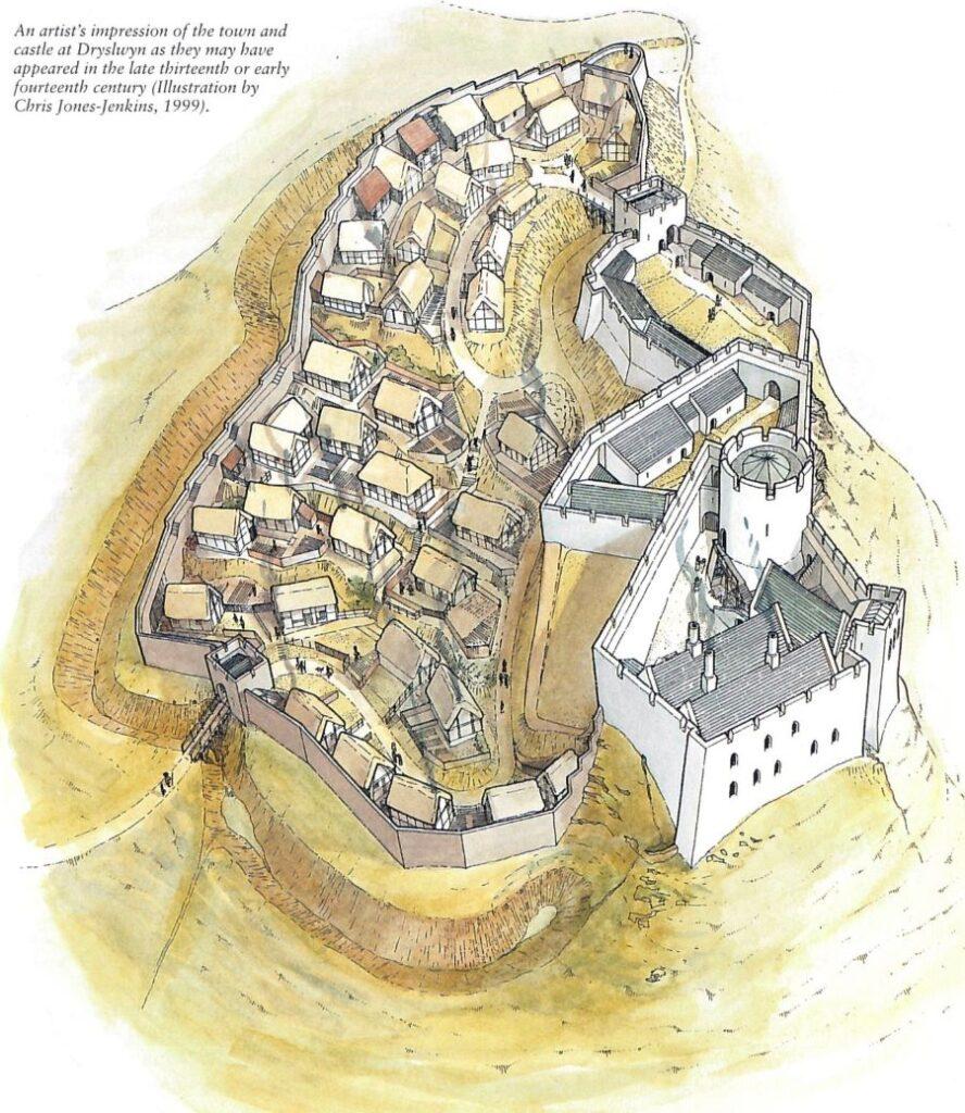
A small, defended, hilltop Welsh town developed outside the gates of Dryslwyn Castle in the thirteenth century. At the end of that century it was transformed into an ‘English’ borough following Edward I’s conquest of Wales. At its peak it consisted of 50-55 houses and was defended by a town wall. It declined during the later fourteenth century and seems to have been largely abandoned by the mid-fifteenth century. Substantial earthworks of house platforms and of the defensive circuit survive on the hilltop. Excavations have highlighted the high archaeological potential of Dryslwyn.
KEY FACTS
Status: Borough. 1391 charter confirmed earlier rights
Size: 1303-04 town of 50-55 houses.
Archaeology: Town gate, section of defence circuit and a house site excavated.
LOCATION
Dryslwyn Castle and town occupy a prominent hill that rises 50m from the floodplain of the Towy Valley in Carmarthenshire (SN 5546 2041). The town of Carmarthen lies 14km downstream and Llandeilo 8km upstream. Dryslwyn sits at a nexus of routeways, with the Towy valley providing an excellent east/west corridor and the Afon Dulas and Afon Cothi valleys giving access to the rolling hill country to the north. A minor valley provides a gateway to the south.
HISTORY
Rhys Grug founded Dryslwyn Castle for his son Maredudd ap Rhys in the late 1220s. A small settlement developed outside the castle gates and in 1281 Edward I granted Maredudd the right to hold an annual four-day fair, an important development in the proto-Welsh town. Defended Welsh towns of the period are rare, but Dryslwyn was such an example as documents in 1287 record payments for cleaning out the town ditch. Following a siege in 1287 Edward I confiscated the castle from Maredudd and set about strengthening it. Edward also greatly expanded the town creating 37 burgage plots and promoting immigration. Of the new burgesses only four were Welsh. Accounts of 1301/04 and 1303/04 record the 37 burgages within the town and 16½ in the vill below the castle. The town now consisted of 50-55 houses, and an estimated population of 250-275. It has been suggested that those inside the town defences were ‘English’ burgesses and those outside lacked the same rights and privileges and were probably Welsh.
Although the presence of burgesses and an annual fair implies borough status there is no known town charter for this early period of the town, and it is not until 1391 that lost charters of 1324 and 1355 were confirmed.
Accounts of 1356/7 specifically mention the town walls and also that some people lived outside the walls on Bridge Street. A bridge over the Towy had replaced the original ford by this date with the 14 burgages outside the walls presumably on the slope leading down to the floodplain. Overall, the town seems to have contracted slightly by 1356/7. The return of the plague to west Wales in 1361 and 1369 probably caused further depopulation and the 1391 reconfirmation of privileges was probably an attempt to rekindle the town. The charter was again confirmed in 1444, but by then it is probable that by then the town was virtually deserted.
MORPHOLOGY
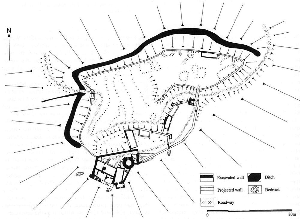
The town and castle occupy the summit and upper slopes of the grass-covered Dryslwyn Hill. Substantial earthworks mark the locations of the medieval houses and the town defences.
Earlier authorities placed the town at the foot of the hill; this has been shown to be incorrect.
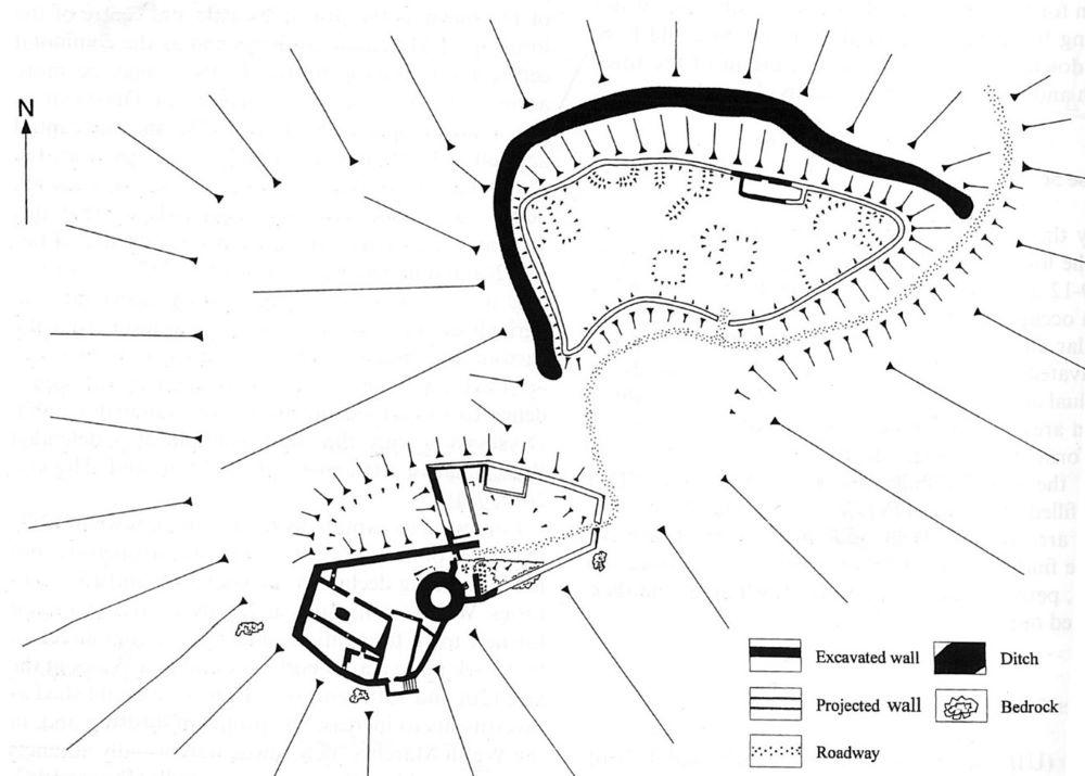
The Welsh town in the third quarter of the thirteenth century (from Caple C 2007, Excavations at Dryslwyn Castle 1980-95, fig. 8.6). Reproduced with kind permission from C. Caple.

The English borough in the early fourteenth century (from Caple C 2007, Excavations at Dryslwyn Castle 1980-95, fig. 8.8). Reproduced with kind permission from C. Caple.
