
LAUGHARNE
Click here for a copy of the full report
SUMMARY
A castle was founded at Laugharne in the early twelfth century and a settlement soon developed outside the castle gates, but it was not until 1247 that Guy de Brian granted Laugharne a town charter, and not until 1465 that a licence was granted to provide the town with walls – this was almost certainly permission to convert earth and timber defences to stone. The area of the walled town was very small and it is likely that by the later medieval period the greater part of the town lay outside the defences. The town declined from at least the end of the sixteenth century and did not start to recover until the end of eighteenth century. Archaeological investigations have demonstrated that significant medieval and later archaeological deposits are likely to survive in many locations in the town.
KEY FACTS
Status: 1247 town charter, weekly market and annual fair.
Size: Unknown – in 1592 161½ burgages were recorded.
Archaeology: Excavations have revealed archaeological deposits dating from twelfth/thirteenth centuries.
LOCATION
Laugharne lies on the west bank of the River Tâf at its confluence with the small River Coran (SN 302 108), Carmarthenshire. Immediately downstream of Laugharne the Tâf merges with the Towy and Gwendraeth rivers forming an extensive estuary. At high tides water laps around the foot of Laugharne castle and town; at low tide the estuary is a wide expanse of sand and mud with the Tâf a narrow channel. The towns of Carmarthen, Kidwelly and St Clears also lie on the tidal Towy/ Tâf/Gwendraeth estuaries.
HISTORY
Excavations in the castle found evidence of Roman occupation (AD second – fourth centuries) and perhaps defensive works taking place immediately before the earliest documentary reference to the castle in AD 1116. As with other castles in southwest Wales, Laugharne alternated between Welsh control and English control. However, in 1247, Guy de Brian took control of the castle and it remained in the hands of de Brian family until the late fourteenth century. The first castle of timber and earth was replaced in stone at the end of the twelfth century, but it was the de Brian’s who transformed the castle into a major stronghold.
In the sixteenth century John Perrot converted the redundant medieval fortress into a Tudor mansion. The work was left uncompleted on his death in 1592. Apart from a siege in 1644 during the Civil War the castle was left to fall into quiet decay until 1973 when the State took it into guardianship and started a programme of restoration.
It is assumed that during the twelfth century a settlement developed organically outside the castle gates. In 1247 Guy de Brian granted Laugharne a town charter with annual fair and weekly market. Ten years later Rhys Fychan burnt the town. A new charter was granted in 1278-82; probably in an attempt reinvigorate a failing town in the aftermath of its burning. The size of the town in the medieval period is not recorded.
In 1465, a licence was granted to wall the town. It seems likely that this licence was for permission to convert earth and timber defences to stone.
A survey of 1592 recorded 161½ burgages in the town.
The town seems to have declined from the end of the sixteenth century, as in 1751 Laugharne Corporation records stated ‘ye whole street from the Gate above the Market House to the Cross the Church of be Ruinous.’ However, the 1840 tithe map shows approximately the same number of burgages as were recorded in the 1592 survey.
In the late eighteenth century Laugharne became a popular place to retire to for those who could not afford Bath and other English spa towns. This resulted in the construction of numerous fine two- and three-storey Georgian houses. However, from the late-nineteenth century the town went into steady decline, experiencing only modest growth until to the mid-twentieth century when a small housing estate was built on the southern edge of the town.
St Martin’s parish church, lying to the north of the core of the town, is a substantial medieval building with limited evidence of it being a pre-Norman foundation.
MORPHOLOGY

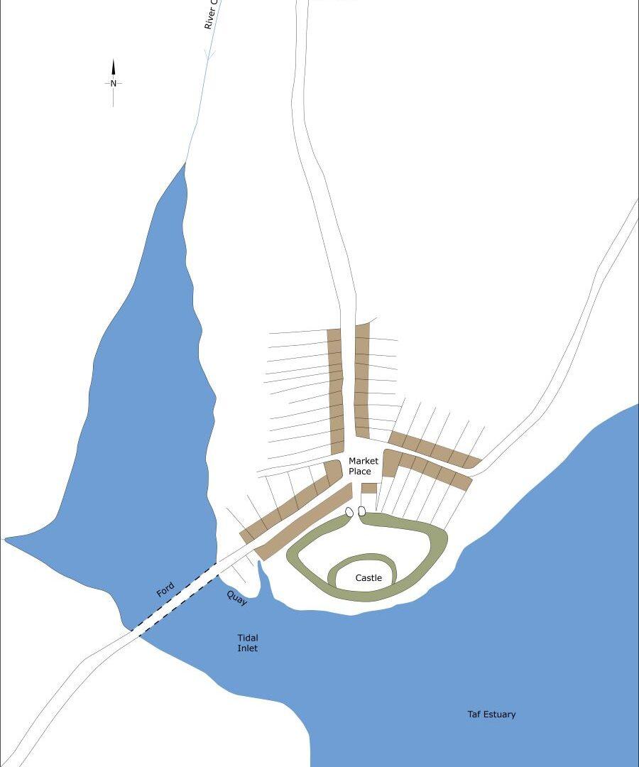
Conjectural plan of Laugharne as it may have been in c.1150.
The castle lies at the heart of the town. The main street, Market Street, leads directly north from the castle. Wogan Street and Duncan Street lead off Market Street to the west and Market Lane to the east. These streets, with the marketplace at the junction of Market Street and Market Lane now occupied by the Town Hall/Market Hall, form the core of the medieval town. Analysis of the 1592 survey demonstrates that there were just 25 burgages within the town defences (32½ if one includes the 7½ that John Perrot acquired for a garden adjacent to the castle – these lay on the south side of Market Lane. Apart from some amalgamation and division the layout of medieval burgages can be traced on the 1840 tithe map and more recent maps.

Conjectural plan of Laugharne as it may have been in c.1320.
The defensive circuit enclosed a small area. One town gate stood at the north end of Market Street, one at the bottom of either Wogan Street or Duncan Street and one probably close to the end of Victoria Street. Some authorities have suggested that the defences enclosed a larger area; this is probably not correct, but massive stone blocks uncovered during the construction of houses at Moir Gardens in the early 1980s could have formed part of a never fully realised extended defensive circuit.
It is highly likely that in the medieval period burgages were laid out along King Street, which continues the line of Market Street to the north. The 1592 survey records 34½ burgages on the west side of King Street and 18 on the east side; allowing for amalgamation of some and division of others these are readily traceable on modern maps.
Until the nineteenth century the parish church of St Martin’s stood in an isolated location to the north of the town. It is only since then that ribbon development has connected the two.
The Grist at the bottom of Wogan Street is traditionally the site of Christ Church on account of human remains turning up, but the name could equally refer to a grist (corn) mill. The Grist was almost certainly a tidal inlet in the medieval period, perhaps the location of wharfs and jetties.
Island House, a structure possibly containing early modern elements, stands behind a high stone wall on the edge of The Grist at the bottom of Wogan Street. Excavations have revealed deeply stratified medieval deposits going back to at least the thirteenth century in the garden of Island House, possibly associated with the port. There are nineteenth century accounts of Roman remains found here. Opposite it was the mill, the structure of which survives but much modified.
Gosport Street winds up the hillside to the south of The Grist. The 1592 survey records 84 burgages on the south side of The Grist and on Gosport Street. The c.1840 tithe map provides a reasonably accurate depiction on these plots.
